Thursday, May 29, 2014

Threat for Locally Heavy Rain Continues

By Jay Grymes & Steve Caparotta


WAFB Storm Team QuickCast:

- FLASH FLOOD WATCH remains in effect until 7 PM Friday
- a welcomed dry-out for most of the WAFB viewing area today
- still the potential for 1” to 3” of additional rain between this afternoon and Saturday


Overall, it's been a much quieter day around the area, although there have been some pockets of 1" to 2" of rainfall. There was also a persistent band of heavy rains from near Lafayette to St. Landry Parish that dumped 4" to 6" of rain earlier in the day, but only a scattering of showers is seen on radar as of 6 PM Thursday.

As mentioned above, there are still opportunities over the next 48-72 hours for significant additional rain, but for now, at least, we are not concerned about widespread flooding rains like we saw on Wednesday. Still, with the juicy unstable air mass in place, we’re maintaining a “rain likely” forecast for Friday and Saturday. The same upper-level low to our north that we’ve tracked the past couple of days is still in play and remains the primary trigger for our wet-weather forecast. However, as we’ve noted these past 24 hours, mid/upper-level inflow of drier air from the west continues to slow the rate of new-storm development over much of our area. 

However, the ‘dry’ air isn’t going to completely stop the rains and that’s we say keep the umbrella handy into the weekend. 

As far as area river gages through this afternoon, only the Tangipahoa at Robert appears headed towards flood stage according to the NWS Lower Mississippi River Forecast Center. Fortunately for those communities, neighborhoods and cul-de-sacs impacted by our local rivers, rains north of I-12 (and east of the Mississippi River) have generally remained under 4” for the event. True, most of the local rivers continue to rise, prompting the closure of a number of waterways around the region and there are numerous roads still closed across the viewing area. But thus far, high water has been relatively manageable for most WAFB communities and neighborhoods. That is “MOST” communities ...

Of course, that is not the case for everyone, with some WAFB communities reporting never-before-seen water levels and flood woes.


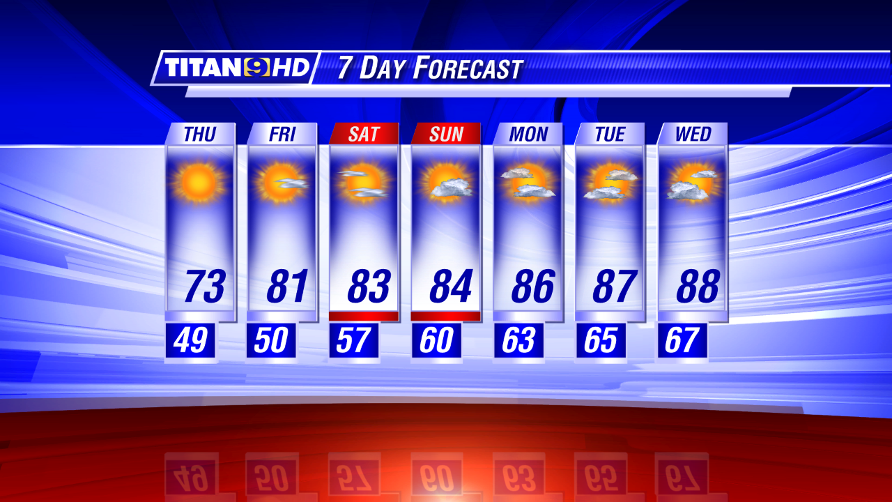
Thankfully, our forecast shows a slow downward trend in “rain chances” as work through the weekend and into early week. Mornings will remain muggy with sunrise temperatures near 70°. As the daily rain chances fall, we can expect the afternoon highs to climb. By the middle of next week, with only isolated afternoon showers in the forecast, expect highs to again approach the 90° mark.

Wednesday, May 28, 2014

Threat of Heavy Rain Continues

By Jay Grymes & Steve Caparotta

WAFB Storm Team QuickCast:

- a rough and exceptionally wet first half of the day
- more rain on the way tonight and into Thursday, stays wet into Friday  
What a way to start the day: widespread rains of 4” to 6” with localized totals of 10” to 12” … Flash Flood Watches and Warnings … confirmed tornado damage in St. John the Baptist Parish …and a Tornado Watch extending from the morning into the late afternoon.

What’s next?
Simple: we’re not done with the wet weather.  The upper-low we’ve mentioned the past couple of days continues to spin -- and remain almost stationary - - to our north and northwest.  As long as it remains intact and in the region, we’ve got the potential for more rounds of storms.  As a matter of fact, models are hinting that we could see another round of activity begin to develop late overnight and into early Thursday morning.  We don’t anticipate anything as wild as what we experienced earlier today but we can’t entirely rule that out either.
There are three ingredients working together that should make for continued wet weather.  First, we begin with our warm-and-moist Gulf air mass at the surface: the steady inflow of Gulf air is a primary fuel for storms.  Then we return to the upper-low: it is generating a steady mid-level flow across our area from the south-southwest while creating vertical shear (increasing wind speeds with altitude) at the same time.  The vertical shear generates lift (of our warm, moist surface air) as well as provides some potential for tornadic development like we saw earlier this morning in St. John the Baptist Parish.  In addition, the upper-low has a cool core which further enhances the vertical transport (lift) of the warm, moist Gulf air.  Rapidly-rising unstable (warm, moist) air means a better chance for strong to severe t-storms.  Add to that the fact that the pocket of cool-air aloft (associated with the upper low) also means a better opportunity for active lightning.
With the upper-low not going anywhere quickly we’re keeping elevated rain chances in the forecast for the next few days: 70% to 80% for Thursday, 60% to 70% for Friday, and 50% to 60% for Saturday.  We don’t expect another round of 5” to 10” rains, but many neighborhoods should be preparing for at least a couple more inches of rain between now and the weekend.  That will not only be a problem for communities along our local rivers but also means standing water problems for places far from traditional river flooding concerns.
By the weekend, we expect the upper low to weaken and that should reduce the rain chances headed into next week.  As a result, our forecasts for Monday into the mid-week call for only limited rain chances - - something typical of early June.

So here we are, with “tropical like” rains without a tropical system.  Let’s just hope that this is not a dress rehearsal by Mother Nature for the upcoming Hurricane Season!
And our sincerest sympathies to those that sustained flood damage today.

Tuesday, May 27, 2014

Run of Wet Days Ahead!

By Jay Grymes & Steve Caparotta


WAFB Storm Team QuickCast:

- Flash Flood Watch in effect for areas west of the Atchafalaya
- rains continue through the week and into the weekend
- totals of 3” to 6” possible by week’s end with locally-higher amounts

Over the past 24 hours, the National Weather Service has come around to our way of thinking with regard to this week’s weather. Prior to today, the NWS was posting slightly lower rain chances each day this week and into the weekend. But now their forecasts are as “wet” -- if not “wetter” -- than we suggested on Tuesday afternoon.

The bottom line: keep the umbrella within reach as we are on the way to a run of wet days and welcomed rain. In fact, the NWS Weather Prediction Center has also upped their extended rain-accumulation forecast, suggesting that the WAFB viewing area could see as much as 3” to 6” of rain over the next 5 to 7 days, with locally higher amounts.


Rainfall potential through 7 PM Sunday from the NWS Weather Prediction Center (WPC).
Rainfall potential through 1 PM on Friday from the RPM model.

Those kinds of rain totals make residents living along and near our south Louisiana waterways nervous ... we’ll have to keep our eyes on river stages, especially if we see widespread totals in the 4” to 6” range by the week’s end. That will certainly mean nuisance roadway flooding, standing water and issues for those spots that always seem to flood. Fortunately, however, our local rivers and bayous are running near base-flow levels thanks to the recent dry spell, so they have substantial storage potential for run-off before they will reach flood stage.

In the meantime, the clouds and rain will keep daytime highs in the low to mid 80°s for the next few days, at least. In fact, some neighborhoods may not get out of the 70°s on Wednesday. However, with dew points up in the upper 60°s to near 70° for many of us, we will have muggy days and humid nights, with morning starts near 70° right through the weekend. The afternoons may be relatively mild but the mornings will have a summer-like feel to them.

So here’s what we’ve got. After today’s rains, we’re going with scattered rains overnight and rain likely for Wednesday, Thursday and Friday. For tomorrow, just about everyone gets wet -- rain chances for your backyard are near 100% for Wednesday. We’ll carry a 70% to 80% rain chance for Thursday and a 60% to 70% chance for Friday. Note that those percentages are slowly falling after peaking on Wednesday and they will continue to fall into the weekend. But we’re still calling for scattered-to-numerous rains for Saturday and scattered, mainly-afternoon rains for Sunday. By Sunday, the scattered nature of the day’s rains will allow afternoon highs to creep back into the upper 80°s.


All of this is being driven by a slow-moving upper-level low currently over the Southern Plains. That low is barely moving to the east and will still be centered near the ArkLaTex on Wednesday into Thursday. The extended outlook suggests that the low will be ‘filling’ (weakening) as it slips over the lower Mississippi Valley towards the end of the week, but it lingers sufficiently to provide support for the weekend rains.

Hurricane season “officially” begins on Sunday. Are you prepared? “Get a Game Plan.” Need some ideas? Check out WAFB’s “Hurricane Center” at:
http://www.wafb.com/category/137830/hurricane-tracking-center

Friday, May 23, 2014

Dry Holiday Weekend...Any Rain in Sight?

By Jay Grymes & Steve Caparotta


WAFB Storm Team QuickCast:

- stays dry through the Memorial Day holiday
- flirting with highs around 90° all weekend
- needed rain in the forecast by mid-week

The good news: looks like a dry Memorial Day weekend for outdoor activities. The not-so-good news: no rain any time soon. Our forecast for the next several days is beginning to read like a broken record -- for those of you old enough to really remember what that means!

So here we go. For Saturday through Memorial Day, metro Baton Rouge and most of our WAFB viewing area can expect morning starts in the mid to upper 60°s under mostly-fair to partly-cloudy skies. Mainly-light, sunrise fog will be a possibility each morning, especially around the usual fog-prone areas. For the afternoons, we’ll go with mostly-sunny to partly-cloudy skies -- with sunscreen-intensity sunshine -- and highs flirting with the 90° mark each day into next week.

And what about rain through the extended holiday weekend? Just about nada.

While the upper-level ridge responsible for this week’s run of dry weather is “flattening” to our north, it will remain sufficiently anchored over the southeastern quarter of the U.S. to maintain the recent status quo weatherwise. Okay, maybe we’ll toss in small chance for a spotty shower on Monday afternoon, but even that’s probably wishful-thinking. In fact, given the dry-run we’ve had, a dry Memorial Day Monday to support area memorial events and ceremonies is probably a good thing.

There is rain in our extended forecast, but when?

Yesterday we we’re thinking a 30% chance for next Tuesday. We may need to back that down a tad as Tuesday is looking a little drier as of this afternoon. But we expect the upper-air ridge currently overhead to be replaced by a trough by mid-week. That should take the ‘lid’ off the atmosphere and allow daytime heating and our warm, moist and unstable Gulf air to work together and do their afternoon raincloud ‘dance.’


Add in an anticipated mid-/upper-level disturbance slowly passing from west-to-east across the lower Mississippi Valley next week and rain chances take a big jump up by the middle to the end of next week. For now, let’s go with scattered rains on Wednesday with scattered to possibly even likely rains for Thursday and Friday.


If you are wondering, the WAFB areas is not “in drought” according to the regional experts. However, drought conditions are in-play nearby, with the southwestern corner of Louisiana currently posted as in “moderate to severe drought” according to the U.S. Weekly Drought Monitor.

Thursday, May 22, 2014

Mainly Dry through Memorial Day Weekend

By Jay Grymes & Steve Caparotta


WAFB Storm Team QuickCast:

- staying mainly-dry through Monday
- flirting with highs around 90° over the next four days
- finally a chance of rain by the middle of next week

The daily forecast for the Capital City is getting awfully repetitive: morning starts in the mid to upper 60°s with some patchy fog, afternoons in the upper 80°s to near 90° under fair to partly cloudy skies, and not a drop of rain falling anywhere for hundreds of miles!

And there’s no real change to the daily outlook through the Memorial Day weekend. That’s good news for the festivals, fun and outdoor memorials that will be on-going through the holiday, but it’s getting very, very dry across the viewing area with no immediate relief in sight -- unless you’re doing the watering yourself!

We’ve mentioned this before: around this time of year, most of our outdoor environments -- both the natural and the ‘landscaped’ -- prefer about an inch of water or more per week, especially given the plentiful sunshine we’ve seen the last several days. But for most of us, the last significant rain was ten or more days ago.

We’re still a long way from “drought” right now, but a prolonged run of more days like the last several would push the area toward drought quickly. Thankfully, our extended outlook offers some relief by the middle of next week. Here’s hoping that pans out.


In the meantime, maybe today’s most anticipated weather story was the NOAA official tropical outlook for the 2014 Hurricane Season. With most models suggesting the onset of an El Niño in the coming months, plus a forecast for near-normal sea-surface temperatures (SSTs) across the tropical Atlantic this season, the NOAA tropical outlook team of experts are claiming a 90% likelihood for a near-normal to below-normal tropical season this year (in terms of storm numbers). Their forecast calls for a 70% chance of only 8 to 13 named storms this season.


El Niño -- characterized by warmer-than-normal SSTs over the central and eastern equatorial Pacific -- is associated with a seasonal increase mid-level wind shear over the tropical Atlantic Basin. More mid-level shear over the Atlantic means a more hostile atmosphere for tropical systems to form and develop. At the same time, the anticipated near-normal SSTs over the tropical Atlantic this season would be a departure from recent years, when Atlantic SSTs have tended to be above normal. As warm water is the source for most of a tropical system’s energy, lower SSTs are presumed to mean a slight reduction in available storm energy for developing systems. Taken together, the NOAA experts -- and most of the private-sector tropical forecasters as well -- see these two factors as key in assessing a lower storm count for the coming season compared to most of our recent years.

However, reduced storm numbers do not directly translate into a reduced threat. Three history-makers for the Bayou State -- Audrey (1957), Betsy (1965) and Andrew (1992) -- all developed during, or in the waning months, of past El Niño periods. Steve Caparotta will take a closer look at the details of El Niño’s role in Atlantic tropical activity in our coming Hurricane Special, “The 5th Season” -- slated for airing on June 2nd!

Tuesday, May 20, 2014

No Rain Anytime Soon...

By Jay Grymes & Steve Caparotta


WAFB Storm Team QuickCast:

- staying mainly-dry through the weekend
- patchy fog each morning, upper 80°s to around 90° each afternoon

This morning’s wake-up fog was a bit more developed and widespread than we had anticipated yesterday ... and you can expect more of the same in the coming days. In fact, don’t be surprised to see Fog Advisories posted on one or more mornings through the week. If you live in or drive through some of those fog-prone locations, you might want to allow yourself a few minutes of extra drive time for the morning commutes this week.

Other than that, we don’t anticipate any notable changes to our forecast for the rest of the week and into the weekend.

We still expect morning lows and afternoon highs to slowly creep upward a degree or two over the course of the work week, with many WAFB neighborhoods flirting with their first 90° days of the year sometime this week. At the same time, dew point readings will remain in the 60°s -- at times in the mid to upper 60°s -- as we maintain a steady low-level southerly flow off the Gulf. The low-level moisture will not only make for a somewhat muggier feel to the air as the week progresses but also increase the morning fog potential.

So when can we expect a little rain? Not anytime soon.


The weekend outlook is a ‘dry’ one for just about everyone although we might see a blip or two on Titan9 Doppler by Sunday afternoon. We’ll also concede a spotty afternoon shower or two for Monday -- but in both cases, even if showers do develop they likely will be so limited as to have no real benefit for anyone. However, we’re a bit more optimistic about rain chances for Tuesday. Unfortunately, in this case, optimism only comes in the form of isolated afternoon showers with Tuesday’s rain chances set at a paltry 20%.

While the kids may enjoy the dry weather and sunshine, the lawns, gardens and landscaping are none too happy. Data from the LSU AgCenter’s climate network suggests optimal watering of roughly one-inch of rain (or more) per week given the warmth and sunshine of the past several days. Given our forecast, that will only happen with a little help from a lawn sprinkler!

And on a completely different note: a reminder that May is Motorcycle Awareness Month. Please watch for motorcycles while driving ... and be courteous to our bicycling friends too!

Monday, May 19, 2014

Warm & Dry Week Ahead

By Jay Grymes & Steve Caparotta


WAFB Storm Team QuickCast:

- slow warming trend continues through the week, becoming more humid
- rain free into the weekend, at least

The one down-side of the past sunny weekend was the Code ‘Orange’ AQI on Sunday -- “unhealthy levels of ozone for sensitive groups.” Other than that, it was a rather nice May weekend. The forecast calls for “moderate” AQIs (Code ‘Yellow’) for Tuesday and Wednesday.

As expected, the upper-level ridge we talked about last week has settling over the central U.S. and the current forecast keeps it anchored there for the rest of the work week and right into the weekend. The ridging will hinder cloud development all week long: that translates into a continued dry forecast. In fact, we’re going essentially ‘rain free’ right through the weekend with only slight rain chances for next Monday and Tuesday.

After those big rains on May 9-11, the following dry-out was welcomed. But this current run of dry weather may be going just a bit too far! With the sunshine and heat expected this week, the lawns and gardens may be in need of a little ‘garden hose’ help by the weekend!


Look for BR metro area morning lows to inch their way up through the 60°s this week: low to mid 60°s for the next morning or two and then mid to upper 60°s towards week’s end. The increase in minimums will be accompanied by rising dew point temperatures as low-level Gulf moisture continues inbound on southerly flow. Not only will that give the air a muggy feel, but we should expect a return of patchy morning fog by mid-week, if not sooner, especially in the usual spots.

As for the afternoons, mid to upper 80°s for today and Tuesday will climb into widespread upper 80°s for the second half of the week with a number of WAFB neighborhoods flirting with highs of 90° or more by Thursday and Friday. By week’s end, most of us get a real taste of summer heat-and-humidity.

If you haven’t had it done in some time, now might be a good time to consider having you’re A/C unit serviced. And don’t forget to clean or change the air filter too.

Friday, May 16, 2014

A Bit Warmer This Weekend

By Jay Grymes & Steve Caparotta

WAFB Storm Team QuickCast:

- lots of sunshine for the weekend
- warming trend continues into mid week, at least
- staying dry for the next 7 days or more
Although most WAFB neighborhoods missed seeing another record low this morning, the cool and dry start to the day was still most welcomed.  It’s mid-May: this could well be the end of ‘comfortably cool’ mornings in the 50°s before summer sets-in.
The warming trend we’ve been mentioning over the past several days began today, albeit rather slowly.  We’ll still enjoy a nice spring weekend before you really notice a return of the Gulf humidity.  Our forecast calls for mostly sunny skies for both Saturday and Sunday, with Baton Rouge highs in the mid 80°s for both days.  Saturday morning will see Red Stick sunrise temperatures in the mid to upper 50°s -- not quite as cool as the past two wake-ups -- with a morning start right around 60° for Sunday.
The morning “muggies” will be back by the start of the work week - - we expect a Monday morning minimum in the low 60°s for metro BR.  Sunrises will be in the mid to upper 60°s for the remainder of the work week for the greater capital area with afternoon highs in the mid to upper 80°s for Monday and then returning to the upper 80°s each afternoon through Friday.

Warm, Mainly Dry into Next Week

Yet, again, we see no rain in the outlook through the next 7 days, at least.  In fact, it looks like dry weather will continue through the following weekend as well.  Now admittedly, after a month’s worth of rain (or more) over last weekend, we can certainly afford a dry-out.  We just don’t want to go too long without our next decent rain.

Source of Upcoming Run of Dry Weather?

Why the upcoming dry spell?  Check out the forecast for the jet stream.
The unusually cool start for the past two mornings was courtesy of a deep southward dip in the Polar Jet flow (a trough), allowing cool-and-dry Canadian air to plunge all the way to the northern Gulf.  That trough is now shifting to the east and filling (retreating) to the north.  In its place, the upper-level weather feature that will control our weather is an approaching ridge.  As we’ve discussed over the years, upper-level ridges typically result in warm and mainly-dry weather.  The extended outlook has a broad upper-air ridge moving over the center of the U.S. over the next several days and remaining anchored there through most or all of next week.
Upper-level ridges are characterized by sinking air and that sinking effect acts like a “lid” on the atmosphere, minimizing the ability for daytime heating to generate clouds.  No clouds, no rain.
The sinking air also helps warm the lower levels of the atmosphere (sinking air gets warmer as it descends).  In addition, by reducing cloud development the ridge effectively allows more sunshine to reach the ground, which typically means a bigger daytime warm-up.  With this set-up expected to last right through most or all of next week, we won’t be surprised to see some WAFB neighborhoods reach 90° or more at some time during the latter half of next week.
In the meantime, enjoy the dry weather and weekend sunshine ... and consider a little sunscreen if you’re going to spend a good amount of time under the sun!

Thursday, May 15, 2014

More Record Lows?

By Jay Grymes & Steve Caparotta


WAFB Storm Team QuickCast:

- another record low for Friday morning? 
- a modest warming trend ahead, but fine spring weather continues through the weekend

This morning’s sunrise arrived with upper 40°s to low 50° for many WAFB communities, setting new record lows all over the place! And the ‘dry’ Northwest-to-northerly winds made for a fine May afternoon, with most WAFB neighborhoods topping out in the low to mid 70°s. And there is still more great spring weather to come as we enjoy a prolonged run of rain-free days.


Thursday morning lows. Record lows indicated by an *.

Another Record Low on Friday?


Maybe the biggest weather question for the next few days will be about Friday morning’s low: another record low on the way? Baton Rouge’s current record low for Friday (May 16) is 51°, set in 2006. So how cool will it be for Friday’s wake-up? The answer will be determined mainly by how long of a delay we get before the surface winds shift around to the southwest.

Our latest guidance suggests a southwesterly component to the light, overnight winds developing as early as midnight: that would slow the pre-dawn temperature fall. However, if the swing to the SW holds off until something closer to sun-up, that would allow for a lower morning minimum. Remember, we’ve mentioned in the past how temperatures for the second morning are often the lowest during these kinds of brief cool snaps. This time around, it will largely depend on the overnight winds. We’ll call for a Metro Airport low of 50° again for Friday morning -- the same as we saw this morning and low enough to break another record.

Warmer Friday into the Weekend


We’ll begin a warming trend through the day on Friday and into the weekend as the winds maintain a southerly component (flow off the Gulf) over the coming days. Warmer, yes, yet still just fine for some outdoor fun or yard and garden work. We’ll see mainly sunny skies for Friday afternoon with highs around 80° or so, then it’s fair skies through the weekend with afternoon highs returning to the low 80°s for Saturday and climbing into the mid 80°s for Sunday.


Of course, the flow off the Gulf means an upward trend in humidity as well as temperatures, but the rise in both will be rather modest. Even Sunday afternoon should be reasonably comfortable outdoors. For the indoors, you’ll likely run the A/C ... and for outdoors, we recommend a little sunscreen.

Extended Outlook


Our forecast continues to stay essentially rain-free through the coming week. By the early part of the work week, we’ll be back to somewhat muggy morning starts in the 60°s with afternoons in the mid and upper 80°s under fair to partly-cloudy skies -- about normal for mid May. And as we mentioned yesterday, most of our reliable extended guidance not only keeps the work week dry, but keeps NEXT weekend dry too.

Wednesday, May 14, 2014

Record Lows Possible!

By Jay Grymes & Steve Caparotta


WAFB Storm Team QuickCast:

- clearing out tonight
- record lows possible for Thursday & Friday mornings
- looks mainly-dry through the next 7-10 days

For most of us, today's main rains arrived before the lunch hour. There were two somewhat distinct rainmakers at work across the South: a rather weak cool front which was already east of Baton Rouge by mid/late morning and a mid/upper-level disturbance located to our west and northwest. 

The clouds and scattered rains kept the air rather muggy but also held daytime highs in the 70°s through the morning, but the cooler air began arriving by mid-day with Red Stick area temps dropping into the 60°s by the early to mid afternoon.

The cool front generated some local showers and a few t-storms along a north-to-south line in the morning. Titan9 Doppler even suggested that the bigger storms closer to the coast may have generated some small hail earlier in the day. But as we headed into the mid-day and early afternoon, the two main bands of showers and embedded t-storms were east of the Capital City, leaving just a few sprinkles in and around the viewing area for the remainder of the afternoon. At the same time, the upper-air disturbance to our west and northwest tracked towards the northeast, keeping most of its rainmaking potential north of the WAFB viewing area.


Drying Out, Turning Cooler!


We say, "good riddance!" -- our area has had more than enough rain over the past five days. Let's get to the sunshine. And that's exactly what we're going to do; in fact, not only will we get a nice run of fair-and-less-humid days (albeit brief), but we’ll flirt with some record lows for both Thursday and Friday mornings!


Normal daily lows are typically in the mid 60°s for Baton Rouge. (As a reminder, for weather scientists, 'normal' means a 30-year 'smoothed' average, and current normals are based on observations from 1981-2010). However, our forecast for the next two mornings is calling for lows in the upper 40°s to around 50° for just about everyone along and north of the I-12 corridor. For Baton Rouge, anything at or below 50° on Thursday and Friday will establish new record lows.

Thursday will be gorgeous with sunshine and blues skies, highs in the low 70°s for metro BR, and dew point temperatures in the 30°s and 40°s -- May dew points are typically in the 60°s. A modest warm-up begins on Friday under mostly sunny skies as we climb up to around 80° or so for the afternoon.


Warmer, Staying Dry into the Weekend


Although Gulf humidity will slowly creep back into the viewing area through the weekend, both Saturday and Sunday look just fine for some outdoor fun. We're calling for a mostly sunny Saturday with highs in the low 80°s and a fair-to-partly-cloudy Sunday with highs in the mid 80°s -- it’s a "sunscreen weekend" for sure.


For the time being, our extended outlook stays dry too. In fact, our key extended-range guidance tools suggests that we stay essentially 'rain-free' not jus through this weekend but also right into -- and possibly through -- the following weekend (May 24-25).

Tuesday, May 13, 2014

More Rain on Wednesday

By Jay Grymes & Steve Caparotta

WAFB Storm Team QuickCast:

- isolated showers & patchy fog for Wednesday’s wake-up
- showers & t-storms likely for Wednesday PM
- looking good for Thursday through Sunday
Not a lot of change in our forecast thinking from yesterday.  As expected, there has been a scattering of showers this afternoon with occasional rumbles of thunder, but many WAFB neighborhoods stayed dry.  While there was no severe weather, we did receive several pictures of a funnel cloud spotted near Erwinville around 5 p.m. This was likely a 'tropical funnel' -- a type of funnel cloud that forms in humid airmasses, but usually doesn't touch ground or cause significant damage.
Funnel cloud near Erwinville. Credit: Julie Arceneaux
We've been watching a rainy mess in Texas over the past 24 hours thanks to a spring front that has been creeping from west-to-east across the western half of the Bayou State today.  The slow-mover has prompted the NWS to issue a series of Flash Flood Watches over the past two days, extending from northern Arkansas to NW Louisiana and into South Texas.  While there have only been a handful of Severe T-Storm Warnings issued with the frontal system over the last 48 hours, local-heavy rains have resulted in a number of Flood Warnings in Texas and even western Louisiana between yesterday and today.
However, even with its slow forward advance, the front has moved too far to the east with respect to its upper-level trough.  In effect, the front has lost a good bit of its upper-air support (‘lift’) which has resulted is subsiding rains through the day.  However, the upper trough will begin a more progressive move to the east tonight and early tomorrow, bringing life back into the surface front.
At this stage, we are not overly concerned about another round of flooding rains nor do we anticipate a widespread severe weather event.   Still, we note that the NWS Storm Prediction Center (SPC) does include neighboring SW Mississippi under a "Slight Risk" for severe weather on Wednesday.
Our latest in-house RPM model does suggest that we could see a few stronger t-storms, especially for areas north of the east-west interstate corridor.  In addition, while our currently shows most of the WAFB viewing area as receiving less than an inch of rain between now and Wednesday evening, a few areas could see as much as 1" to 3" where the stronger storms develop.  Those kinds of rains could generate another round of rises along our regional rivers and streams, but we think that the heavier rains will be isolated and localized, so that there is no real threat for the main channels -- like the Amite, Comite, Tickfaw and Tangipahoa -- to reach flood stages.
Our latest RPM model run clears things out fairly quickly, with skies over metro BR clearing by the evening hours.  And once the skies clear, we're all in for a nice spring treat.
Our forecast for Thursday through the weekend is not only dry, but quite pleasant in terms of temperatures and humidity.  A cool-and-very-dry Canadian air mass will deliver near-record to record lows on Thursday and Friday: low to mid 50°s for Thursday morning and upper 40°s to low 50°s for Friday's sunrise.  Highs on Thursday will top-out in the mid 70°s for metro Baton Rouge and only get up to around 80° or so For Friday.
And while temperatures (and low-level humidity) will show a slow rise through the weekend, the regional weather will still be rather pleasant by mid-May standards, making for a couple of good-looking "Get outdoors!" days.

Monday, May 12, 2014

Awaiting More Rains Later This Week

By Jay Grymes & Steve Caparotta

WAFB Storm Team QuickCast:

- scattered mainly-afternoon t-showers on Tuesday
- cool front, showers & t-storms likely on Wednesday
- dry-out, cooler & less humid for the rest of the week

Recap of Weekend Soaking

For many of you, maybe even most of you, your backyards received a month's worth of rain or more over the last four days -- so much for the drought.
In fact, with widespread 4" to 6" rain totals, and pockets of upwards of 8” or more, over the last several days, the excess rains had the WAFB Storm Team closely watching the rivers over the weekend.
Street flooding has been an issue for a number of neighborhoods in the viewing area and some yards are still dealing with standing water.   But in the end, the region had become so dry over the past few weeks that most area rivers were showing relatively low-flows for the spring before the rains set in.  As a result, while some smaller creeks and bayous climbed out of their banks briefly, the larger channels -- the Amite, Comite, Tickfaw and Tangipahoa -- all stayed below flood stage.  And as of this morning, most of the standing water on area roads had receded.

More Rains into Midweek

Today's rains were a bit more scattered and generally brief, so there weren't any serious roadway issues for the evening commute.  However, it sure warmed-up in a hurry and there was no mistaking that summer-like humidity, a reminder that we are still under the influence of moist-and-unstable Gulf air.
We're expecting another round of scattered mainly-afternoon thundershowers on Tuesday, with a 'wetter' outlook for Wednesday.  A slow-moving spring front will be approaching the lower Mississippi Valley from the west over the next two days.  We remain in the "warm sector" (ahead of the front) on Tuesday, with daytime heating and the unstable air mass in place serving as the rain-making ingredients.
Based on the current guidance, it looks like the front arrives during the first half of the day on Wednesday but then slows to a crawl as it moves through our viewing area.  We’ve got scattered showers and t-storms arriving in the morning with the rains becoming likely by mid-day and into the afternoon.
As of now, we are not concerned about a widespread severe weather threat developing, although a few of the storms rolling along and ahead of Wednesday's cool front could become 'strong' to possibly ‘severe.’  But given the slow movement anticipated with Wednesday’s front, we’ll be watching for another round of significant rains - - not a repeat of what many of you saw on Friday, but remember, given that the area is fairly saturated, it won't take a lot of rain to generate some nuisance street flooding once again.
The rain should taper off late Wednesday or early Thursday, with a cooler-and-drier Pacific air mass moving in behind the cool front.  Highs on Wednesday will top-out in the upper 70°s for most WAFB communities, in part because of the clouds and rains.  By mid-day Thursday (if not sooner), we'll be enjoying clearing skies and a big dip in the humidity.  Thursday morning minimums will drop into the low to mid 50°s for many WAFB neighborhoods -- about 10° below normal.

Extended Outlook

But that’s not all: there is a double-bonus headed our way, as a reinforcing surge of even cooler-and-drier Canadian air arrives on Thursday into Friday.  By Friday morning, communities along and north of the I-10/12 corridor could be flirting with record lows as sunrise temperatures drop into the upper 40°s to low 50°s.
Comfortably-dry air and sunny skies will be the rule for Friday and Saturday, with temperatures (and humidity) slowly creeping upwards on Sunday and Monday.  Still, Sunday looks very agreeable with highs in the mid 80°s and far from the muggy air we've had the last few days. Bottom line: we anticipate a nice spring weekend ahead.
So … after our multi-day drenching, the dry-out and sunshine will be good news for the lawns and gardens -- and have many of us running the mowers by or before the weekend!

Thursday, May 8, 2014

Wet Forecast into the Weekend

By Jay Grymes & Steve Caparotta


WAFB Storm Team QuickCast:

- rains on the way for Friday & the weekend 
- scattered rains extend into early next week
- cooler, drier air arrives behind a mid-week front

Yesterday we were talking about a 20% to 30% rain chance across the WAFB viewing area for today ... obviously that hasn't materialized. In fact, as of 4PM there’s hardly been more than a couple of micro-blips on Titan9 Doppler anywhere near our WAFB communities. And the lack of rain clouds likely added to the day’s warm-up, with a high of 89° for BR’s Metro Airport.

However, we're still thinking "rain likely" for Friday and Saturday with scattered mainly-afternoon rains on Sunday, so you'll need to get your hands on the umbrella for the next several days.

Over the past 24 hours, we’ve seen some noteworthy changes to the outlook for the next few days. First, while Friday still looks "wet" for just most of us, it looks like the coverage may not be quite as widespread as we thought yesterday. And we might -- just might -- get a bit of a break from the rains during the evening hours: good news for downtown's 'Live After Five,' LSU baseball (Alabama is in town), and Mid-City's "Hot Art, Cool Nights" street fair. But we say it again: MIGHT get a break.

Second, it now looks like Saturday may be the ‘wetter’ of the upcoming three days -- yesterday it sure looked like Friday was going to the rainiest of the three. That is not such good news for Saturday morning's "March for Babies" in downtown BR. We're keeping scattered, mainly-afternoon rains in the forecast for Sunday through Tuesday as well.


But maybe the biggest change is the adjustment in expected rain totals posted by the NWS Weather Prediction Center (WPC). WPC's 7-day outlook for our viewing area on Wednesday was running in the 2" to 4" range. Yet as of this morning, the WPC forecasters backed way off on those numbers, now suggesting something closer to 1.0" to 1.5" for the upcoming 7-day run. (If you read our blogs earlier this week, that's closer to what we were projecting earlier in the week up until yesterday's 'jump' by the WPC.)

So what happened to that very-wet outlook? The main factor here appears to be that the eastbound upper-level trough -- currently over the Central Rockies -- may not dig as far south as previously though as it tracks across the Plains and Mississippi Valley. That means less "lift" for our warm-and-moist Gulf air mass. Less lift equals less rain. Having said that, a couple of models still paint a 'wetter' picture, including our in-house RPM.


We'll still get wet, especially on Friday and Saturday, and there will be some rumbles of thunder to accompany the rains for Friday and the weekend. But instead of the helpful upper-level lift that we expected, most of the lift will depend on daytime heating and a weaker west-to-east upper-level disturbance. 

Hey, at this point, even an inch of rain sounds pretty good!

We're sticking with muggy mornings with patchy fog right through the weekend, with sun-up temperatures for the Red Stick running in the upper 60°s to low 70°s through Tuesday -- lows that remain a bit warmer-than-normal for early/mid May. The mix of clouds and rains will also keep highs for most days in the low to mid 80°s for most WAFB neighborhoods as well. 


While we'll get no relief from the building humidity over the next four to five days, our extended outlook does indicate a spring cool front on the way, likely arriving on Tuesday. It will mean another round of showers, but for now at least, Tuesday's front does not have the look of being a severe-weather generator. However, a cooler-and-less-humid air mass behind Tuesday's front should deliver a nice change of pace to our local weather by the latter half of the week, even if only for a couple of days.

Wednesday, May 7, 2014

Time to Dust Off the Umbrellas

By Jay Grymes & Steve Caparotta

WAFB Storm Team QuickCast:

- 30% rain chance for Thursday
- showers and storms likely for Friday and Saturday
- stays unsettled into next week

And the humidity continues its slow rise through the week …

A bit on the breezy side under a sun/cloud mix but we stayed dry through the day. More clouds return overnight with some patchy fog developing by Thursday’s sunrise; morning minimums will be in the mid to upper 60°s for the Red Stick. With the moist low-level air mass in place, we’d expect more than just “patchy” fog for Thursday’s start if it weren’t that the winds will be up just enough to minimize the formation to wind-shielded areas -- the “usual suspect” spots..

Thursday shapes up to be another breezy-to-windy day again under a sun/cloud mix. In addition, we’ll toss in a few showers and maybe a rumble of thunder for the afternoon forecast -- set rain chances on Thursday afternoon and early evening at 20% to 30% for metro BR.

The upper-level ridge that has dominated our weather over the past several days will no longer be a factor by tomorrow evening, with a trough currently over the U.S. West headed our way. The thinking now is that the core of the trough will remain just to our north but gets close enough to generate active lift and get some rain going.

The needed rain arrives in earnest on Friday and Saturday -- just about everyone gets wet over the two-day span. These won’t be textbook frontal rains but our humid-and-warm Gulf air (unstable air) will be more than ready to rise and build into rain- and thunder-clouds. We aren’t expecting a severe weather event either but a few storms in the mid to late afternoons could become strong enough to get your attention.


With the clouds on Thursday and rains for Friday and Saturday, we’re going against some of the forecast tools that are calling for upper 80°s. In fact, some neighborhoods may barely make the 80°s on the two “wet” days. Mornings will be muggy and patchy fog will be part of the wake-up forecast each of the three days.

We’ll ease back a bit on the “rain throttle” for Sunday, Monday and Tuesday but keep scattered mainly-afternoon and early-evening rains in the forecast for all three days.


A noteworthy change in the outlook over the coming days deals with the rain amounts. Through yesterday, the NWS Weather Prediction Center was suggesting 1.0” to 1.5” of rain through early Tuesday. But as of today, that number has taken quite a jump, now running on the order of 2” to 4” or more over the course of the next five days. This is a significant adjustment and we’ll need to track it closely over the coming days -- although the environment is quite dry thanks to our nearly rain-free past three weeks, 4” of rain or more in the right places in such short order could lead to local flood woes. 


Into the extended, the longer-range outlook is currently suggesting a spring cool front will work its way through the viewing area sometime late Tuesday or early Wednesday. That should provide a dry-out after our run of rainy days and also cut back on the Gulf humidity, if only temporarily.

Tuesday, May 6, 2014

Increasing Rain Chances Later This Week

By Jay Grymes & Steve Caparotta


WAFB Storm Team QuickCast:

- stays dry for Wednesday, although a bit more humid
- 30% rain chance for Thursday
- showers and a few storms likely for Friday and Saturday

Just a touch more humid today, making it feel a little warmer in the afternoon but today was yet another in a string of dry-weather days. And our forecast for Wednesday calls for much the same as today's weather, with a continued slow increase in low-level humidity. So expect another round of patchy wake-up fog for Wednesday's start with morning lows in the low to mid 60°s for metro Baton Rouge -- just a little warmer than earlier this morning. And like today, Wednesday will be marked by a mix of sun and clouds as afternoon highs climb into the mid 80°s for the Red Stick. Wednesday will be a bit breezier than today, with south-to-southeast winds running in the 10-15 mph range through the afternoon.

We'll concede the possibility of a spotty shower or two, but the day will be a dry one for just about every WAFB community -- put Wednesday's rain chances at 10% or less.


Dry Last 2-3 Weeks


And for many of you, more dry weather is not what you want to hear. 

The upper-soils are getting very dry for most of our viewing area and some yards are beginning to get that 'crunchy' sound as you walk over the dry grass. Over the past three weeks, a few WAFB areas have received upwards of 2" of rain -- but for many more, they've had less than 1" of rain over that same three-week period. 


No, it is not a full-blown drought ... but it is certainly dry. Normal rainfall at this time of year averages about 1.0" to 1.5" per week. During the cooler months of the year, an inch of rain is more than enough to keep the vegetation happy. But by mid spring, with temperatures getting into the 80°s on a routine basis, the lawns, the gardens and our natural vegetated landscapes like to use just about all of that inch of rain each week when they can get it.


Rains Arrive Later This Week


Thankfully our forecast for the latter half of the week and the weekend offers some relief. 


We'll go with a 20% to 30% rain chance for Thursday, then really turn on the sprinklers for Friday and into the weekend. The air will remain warm and muggy throughout, with morning starts in the upper 60°s to low 70°s and afternoons returning to the 80°s each day right into next week. The rain -- with occasional t-storms -- will still be welcomed by most of us even if it means dodging showers on Saturday and Sunday.

We won't be getting a spring cool front anytime soon but the low-level Gulf air mass will become sufficiently unstable each day to get the showers going by the mid to late afternoon. Daytime heating will help do the trick in providing a little extra boost for the rising moist air to feed cloud development. Of equal importance, the upper-level ridge currently over the central U.S. will begin to break down over the next 24-36 hours, taking the “lid” off the mid levels. 

Extended Outlook


We're calling for rain likely on Friday, with rain chances at 80% or so, with the numbers running at 60% or more for Saturday. We’ll keep scattered mainly-afternoon rains in the forecasts for Sunday, Monday and Tuesday too. Preliminary estimates from the NWS Weather Prediction Center currently suggest that our viewing area could see from 1.0" to 1.5"of rain between now and early Tuesday.