Tuesday, June 30, 2015

Scattered T-Storms Again on Wednesday

By Jay Grymes & Steve Caparotta

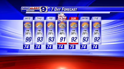
June 30th WAFB First Alert Quickcast:

- scattered afternoon showers & t-storms return for Wednesday
- isolated rains for Thursday & Friday
- back to a summer routine for the July 4th weekend

Looking for WAFB’s Weather App?  Find it here:
- Apple users click here: http://shout.lt/42Rq
- Android users click here: http://shout.lt/42Q8
.. or text WEATHERAPP to 99009 …

And for yet another day, some fairly strong t-storms rocked parts of the viewing area.  Unlike last night’s late-night storms and the action last Tuesday and Wednesday, these storms were not out of the north and northeast.  However, they were still quite energetic and lightning-laden, fueled by our very most and unstable Gulf air.  What’s more, they got an additional boost from a pair of features working together: a sea-breeze-like wave heading inland and what appears to be a broad-but-weak non-tropical disturbance moving to the west-northwest over the western Gulf.

Bottom line: a very active middle of the afternoon for metro Baton Rouge and western Livingston Parish, sections of the Felicianas and points west including parts of Pointe Coupee, Avoyelles and St. Landry parishes.  Once again, the most noteworthy aspect of these storms was the lightning - - which is credited with power outages and even one or more fires.  But we can’t ignore the reports of small hail from WAFB viewers as well as locally-heavy downpours that produced more rounds of street flooding.

The action will wind down into the evening and most of us will stay dry through the overnight and early morning hours on Wednesday.  We could see a few showers down near the coast for Wednesday’s sunrise, but the morning commute for metro BR should be a dry one for just about everyone.  Plan for a muggy, partly-to-mostly cloudy start to Wednesday with morning temperatures in the mid 70°s.

For Wednesday afternoon, here they come again: 50% rain chance with highs getting up to around 90° before the rains arrive. 

The weather gets much quieter for Thursday and Friday, with rain chances for both days currently posted at 20% or less.  Both days start off in the mid 70°s for the Red Stick and afternoon highs reach the low 90°s for most, with a few neighborhoods potentially sneaking into the mid 90°s.


And into the Fourth of July weekend, we return to something fairly typical for this time of year: morning starts in the low to mid 70°s for the metro area, afternoon highs in the low 90°s, and scattered mainly-afternoon t-showers for both days.

Friday, June 26, 2015

More Rain This Weekend

By Jay Grymes & Steve Caparotta

June 26th WAFB First Alert Quickcast:

- weekend cool front still on the forecast board

Today was yet another afternoon with scattered showers and storms … but the action was less substantial than what we saw on Thursday and nothing at all like the big boomers and excessive rains of Tuesday and Wednesday.  Today was something more “normal” for a summer day in the viewing area.

There is a change coming this weekend in the form of a summer cool front.  We can’t call summer fronts “rare” but they certainly aren’t very common.  During the winter and spring, we can expect to see five or six frontal passages -- sometimes even more -- each month, on average.  By comparison, during the summer season, that number drops to something closer to an average of one or two passages per month.  And often, our summer fronts don’t push all the way through the area: they stall near or along the coast and sit there until they fizzle-out.

That is precisely what we are expecting this weekend: a cool front will slide south out of the U.S. Plains and reach the WAFB area by Saturday afternoon and evening.  Then it simply stalls along or near the coast for the remainder of the weekend.

If that front would continue southward and move out over the Gulf, we would get a nice change in our weather.  A completed frontal passage would deliver slightly cooler temperatures and, even more welcomed, a big drop in our local humidity.  (90° afternoons don’t feel so bad if the air is less humid).  Unfortunately, our guidance is suggesting that the weekend front will stall somewhere along or near the coast late Saturday and then linger there into Monday before dissipating.

Fronts usually mean rain in the local forecast no matter what time of year.  So our weekend cool front will be a focus for rains on Saturday afternoon and evening -- by adding extra lift to our typical hot, humid and unstable sub-tropical Gulf air.  Then, with the front lingering near the coast into Sunday, we’ll keep “rain likely” in the overnight and morning forecast for our viewing area.


In the spring, a frontal set-up like this could mean some nasty weather and another round of potentially large rain totals.  Fortunately, summer fronts along the Gulf Coast tend to be less energetic than their winter and spring counterparts.  That said, we’ll still get showers and storms with this frontal boundary and we can’t rule out a few strong to severe storms as it settles over the area.  But with the front over the area at night rather than during the heat of the day, the threat for severe storms is reduced somewhat.

The rains will continue into Sunday morning, but rains on Saturday afternoon and into the overnight hours will take a big bite out of the local atmosphere’s storm energy, with rains winding down as we head towards Sunday mid-day and afternoon.  We’re not ready to say “rain free” for Sunday afternoon, but it’s looking like isolated showers with the majority of WAFB neighborhoods staying dry into Sunday afternoon and early evening.  In addition, clouds and morning rains on Sunday will slow the daytime warm-up, with just about all of us topping out in the 80°s for Sunday afternoon.

So how “cool” will it get?  Most viewers in the coastal parishes will get little or no relief from the humidity, which means not much change in terms of morning lows on Sunday and Monday.  For the northern half of the viewing area, if the front can make its way as far south as the coastal zone, at least some communities north of the I-10/12 corridor could slip into the upper 60°s on one or both mornings. 

We’ll go with morning minimums on both days close to 70° for metro Baton Rouge: not much of a change but at least a couple of degrees cooler -- and a little less humid -- than the past several days.

As for next week, our current extended outlook calls for a return to our traditional summer routine at least through mid-week: morning lows in the low to mid 70°s, most afternoons climbing to 90° or more, and scattered mainly-afternoon showers and storms just about every day.


How about the tropics?  Dead quiet.  While there are a few tropical waves running in the easterly tropical flow (and that is normal), none of them show any potential for development.

Eyes to the skies on Saturday afternoon … but here’s hoping that you get to enjoy the weekend!

Wednesday, June 17, 2015

Hot & Humid, Isolated Showers

By Jay Grymes & Steve Caparotta


June 17th WAFB First Alert Quickcast:

- ‘Bill’ continues chugging northward
- summer heat, humidity and afternoon showers locally

Tropical Depression Bill continues moving steadily to the north and is still expected to begin a turn to the northeast over the next 24 hours. Bill has been quite the rainmaker for parts of Texas -- sadly, in some places that really didn’t need more rain. 


For most of Louisiana, however, Bill failed to leave much of a calling card. While there have been some pockets of 1” to 2” rains over the western parishes, and even T-Storm Warnings in the northwestern part of the state, most of the Bayou State saw little in the way of noteworthy weather. Thank you for that favor, Bill!

We should note that while Bill’s landfall was roughly 170 miles southwest of Cameron Parish, the Lake Charles NWS office has reported multiple locations in that parish with sustained winds of 40 mph or more -- tropical-storm strength. And the NHC’s wind field projection during Bill’s peak strength suggested that tropical-storm winds could indeed reach into the westernmost portions of Cameron Parish. So technically, does this confirm a tropical-storm impact by Bill on the Bayou State? It will be interesting down the road to see how the NOAA tropical experts evaluate it.

Meanwhile, weatherwise for us, it’s shaping up for a steady dose of typical summer weather for the central Gulf Coast right into the weekend. The line-up reads like this: morning lows in the low to mid 70°s, afternoon highs in the low 90°s, and a steady influx of humid Gulf air that keeps dew points in the 70°s. That will mean afternoon Heat Index readings topping out in the upper 90°s for many WAFB neighborhoods, with occasional readings at 100° or more. 

Be extra careful in the heat, especially if you are spending time under direct sunshine. And please remember the pets too!

Rains chances will run in the 20% to 30% range for Thursday and Friday and probably right through the weekend. As we’ve mentioned over the past few days, the upper-air ridge centered over the Southeast U.S. that steered Bill away from us also kept rain chances in our area on the lower end (isolated at best) over the past couple of days. That ridge is likely to shrink a bit and shift a little eastward over the next couple of days, allowing for ever-so-slightly higher chances for afternoon showers on Friday and Saturday. But even then, we’re talking 30%, which is still at or below normal for mid to late June.

As we head into Sunday and next week, models are indicating the development of upper-air ridging over the Desert Southwest, putting us under the influence of dry, northwesterly flow at the mid- and upper-levels. That should keep rain chances in the 20% to 30% range for Sunday and Monday, and possibly right through the middle of the upcoming work week.


So it’s summer heat-and-humidity for the end of the work week and the weekend, with the occasional passing shower that might be welcomed as a nice mid-afternoon heat-breaker.

And in the tropics, the NHC notes four tropical waves over the Atlantic Basin, with a fifth about to move off the western coast of Africa, but none show any significant signs for potential development, at least not in the next three to five days.

Tuesday, June 16, 2015

Bill Moving Inland...Hot, Humid Locally

By Jay Grymes & Steve Caparotta

June 16th WAFB First Alert Quickcast:

T.S. Bill moving inland over Texas
- muggy mornings followed by hot-and-humid afternoons will be the rule locally

T.S. Bill made landfall along Matagorda Island along the central Texas Gulf Coast just prior to the lunch hour today.  Peak sustained winds at landfall were estimated at a respectable 60 mph with higher gusts, making Bill a formidable tropical storm as he headed inland.

After making landfall, Bill stalled and meandered along the coast for several hours.  By 3:00pm, however, it looked as though Bill had begun slowly moving again to the North to NNW, and the 4:00pm NHC Advisory indicated that Bill had begun weakening with sustained winds at 50 mph.

The tropical forecast keeps Bill well to our west through mid week.  ‘His’ impacts in Louisiana will be periodic rains for the western parishes, but even there most rain totals through week’s end will come in at around an inch or less.  And for us in WAFB-land?  Very little in the way of a Bill weather signature other than a breezy couple of days.

For Texas and Oklahoma, however, it’s another round of very soggy weather.  The forecast from the NWS Weather Prediction Center (WPC) indicates a swath of 4” to 8” rains extending from the coast into the middle of the Red River Valley (where they just endured record-setting rains).  And that’s where Bill will likely have ‘his’ biggest effect: prolonging the high water along the Red River is it passed through northwestern and into central Louisiana.


What Bill does give WAFB viewers is a quick refresher course that tropical systems can bubble-up fairly quickly over the Gulf.  Texas coastal residents had only 36 to 48 hours to prep for this system: would you have been ready for a couple of days without power had Bill taken a turn to the northeast and beat a hasty path in our direction?  Bill serves as a reminder to make sure that you, your family and your business have “tropical game plans” in place and that you are ready to go.

Meanwhile, we’ll get an extended run of relatively dry weather through the week and weekend.  A high-pressure ridge centered over the southeast U.S. appears ready to remains in place into next week.  That same ridge is the key steering agent accounting for Bill’s forecast path, with the western margin of that ridge extending across the Bayou State and into East Texas.

While the ridge won’t fully deter afternoon showers from popping up in our viewing area, it will be a persistent inhibitor to raincloud formation through the coming weekend.  We’re posting regional rain chances in the 20% to 30% range for most WAFB communities right into next week. 

Less cloud cover means more sunshine and that adds to the usual daytime heating.  In the meantime, our low-level flow will continue to come off the Gulf, keeping the air humid.  With dew points in the 70°s, we can expect morning minimums to stay in the low to mid 70°s right through the next seven days for the Red Stick.  And that moist air will combine with daytime highs in the low to mid 90°s to push peak daily Heat Index readings up to near or even above 100°!


So, enjoy the drier weather spell … but be extra careful in the summer heat!

Monday, June 15, 2015

Tropical Rains for Texas...Minimal Impacts Locally

By Jay Grymes & Steve Caparotta

June 15th WAFB First Alert Quickcast:
- much attention on the western Gulf and Invest 91L

- much attention on the western Gulf and Invest 91L
- declining rain chances locally over the next few days

Yes, a good deal of attention this weekend and today was focused -- and remains focused -- on the tropical disturbance in the western Gulf - Invest 91L.  Assessment of Hurricane Hunter data earlier in the day by the national Hurricane Center (NHC) pros indicated that the disturbance has yet to achieve the complete structure to be classified as a tropical cyclone (either a tropical depression or a tropical storm) - - however, there is little doubt that the system is awfully close as of this afternoon. 

Why not a tropical storm as yet?  The NHC stated that a clearly-defined low-pressure center has yet to sufficiently consolidate to earn cyclone classification, although there is ample evidence of tropical-storm force winds in the region.  Another Hurricane Hunter aircraft is scheduled to visit the disturbance this evening, and we suspect that it will collect the evidence needed for upgrade to Tropical Storm Bill. 

Virtually every major tropical forecasting model takes this system into the Texas Coast and then northward into the Southern Plains -- bad news for the already-flooded Red River region but good news for the Bayou State.  Parts of Louisiana could receive some east-side wrap-around rainbands from the tropical system over the several days but it appears as though the main storm energy misses us.


Note that there are Coast Flood Advisories - - and Warnings - - either already in effect or anticipated for Louisiana, but most of this is a result of the steady southeasterly winds that have been impacting the region and are expected to continue.  However, winds along the central and western Louisiana coast are likely to show additional increases due to the larger-scale flow around the tropical system as it continues along a northwesterly track into Texas.

For most of us, however, we can expect a turn to a slightly drier regime over the next couple of days or so.  High pressure ridging, centered over the southeastern U.S. will serve as a modest inhibitor for our afternoon thundershowers -- not fully shutting off the afternoon rains but keeping them in the 20% to 30% range for our viewing area for the next three days.

The “muggies” will stay with us all week long.  While we may see a little less in the form of rain coverage, moist Gulf air will remain in place all week long.  Look for afternoon highs in the 90°s each day, with morning starts in the low to mid 70°s for most WAFB neighborhoods - - and upper 70°s at sunrise for the more southern parishes.


So here we are, only two weeks into the Hurricane Season and we could have our second ‘named’ storm?  What happened to the forecast for below-average storm numbers?  It’s still on the table, but we admit that the average date of the second ‘named’ storm in the Atlantic is August 1st!

Friday, June 12, 2015

Staying Soggy This Weekend

By Jay Grymes & Steve Caparotta

June 11th WAFB First Alert Quickcast:

- rain likely through the weekend

As expected, the showers and storms were rather numerous for our area today.  It took a little time for the action to really get going and fair to partly-cloudy morning skies for many WAFB neighborhoods allowed the sun to drive temperatures up to near 90° by or even before lunchtime.  However, Doppler radar became quite active into the afternoon and the rains knocked temperatures down into the 70°s and 80°s for many communities by mid-afternoon. 

Fortunately, there were no ‘severe’ storms in our area today but a few storms did become rather strong … and a few neighborhoods did receive a pretty good soaking.

In the meantime, satellite imagery continues to show a consistent counter-clockwise spin over the northern Gulf, located just off the Louisiana coast.  This mid/upper-air low/trough was the key factor in today’s wet pattern and it will remain a factor for Saturday and probably Sunday too.  


The circulation around the low/trough will strengthen our typical summertime inbound flow of Gulf moisture over the next two days.  Indeed, water vapor imagery shows a very moist plume of air on the eastern flank of the westward-traveling trough.  In addition, somewhat cooler air aloft associated with the trough creates a steepened vertical temperature gradient (cool aloft and warm near the surface), and an increased temperature difference means enhanced instability (greater lift).  All of these ingredients will likely yield elevated rain chances through the weekend.

Just like today, we aren’t expecting all-day rains for Saturday and Sunday.  However, everyone should be prepared for the potential for multiple rounds of passing showers and storms on both days.

Given the consistent flow off the Gulf, you already know that the days will remain humid, with dew points staying in the 70°s through next week.  And remember, the morning low can’t drop below the dew point temperature -- so expect muggy morning starts in the low to mid 70°s through the weekend and through most or all of the coming work week.

The rains on Saturday and Sunday should mean that highs for most WAFB communities should top-out in the mid to upper 80°s for both days, although a few areas may sneak up into the 90°s.


As we head into next week, the influence of the west-bound trough should slowly wane.  At the same time, high-pressure -- the Bermuda High -- will expand into the area from the east.  We’re still expecting scattered, mainly-afternoon rains for Monday (50% chance), but by Tuesday and Wednesday, the Bermuda High should begin to knock back our local rain chances even with our muggy, Gulf air mass.  For the time being, we’ll call for rain chances at around 40% for Tuesday and then around 20% to 30% for Wednesday and Thursday.  However, less rain (and less cloud cover) will come with a return to the 90°s for most WAFB neighborhoods.

So enjoy your weekend .. and good luck dodging those rains this weekend!

Thursday, June 11, 2015

More Wet Weather into the Weekend

By Jay Grymes & Steve Caparotta

June 11th WAFB First Alert Quickcast:
- rain chances running higher for Friday and the weekend

Our area coverage of showers and t-storms was more widespread today compared to Wednesday … and we’re expecting that coverage to increase even more for Friday and the weekend.

During yesterday evening’s weathercasts, we noted a modest counter-clockwise spin in the clouds just to our east -- the satellite signature of an upper-level low.  Satellite depictions today have made the feature even more apparent, with a somewhat elongated spin located over the southern parishes this afternoon.


This upper-air trough of low pressure is certainly not tropical and does not threaten to develop into a tropical system either.  However, you may have noticed the extra activity bubbling up on its eastern flank as it works with the Gulf moisture by providing added lift.  As this trough slides slowly westward over the next couple of days, it will bring those showers and storms into our viewing area.  End result: rain likely for Friday, Saturday and probably Sunday too.

By the early to middle part of next week, the trough should have moved far enough west to lessen its impact locally.  At the same time, high pressure ridging from the western Atlantic into the eastern and central Gulf should take a bite out of the afternoon showers and storms.  If this forecasts plays out, that should mean a drier forecast for the WAFB area as early as Tuesday and certainly by Wednesday.

Regardless, our humid Gulf air mass will remain in place throughout.  The difference between the next few days and the middle of next week will be the shift in “controlling” mechanisms: from the upper trough to the high-pressure ridge. However, the humid air likely keeps morning lows in the 70°s through the next 7 to 10 days for metro Baton Rouge.  Over the next few days, those mornings are likely to also start out with at least isolated morning showers (especially along the coast), with the coverage increasing through the morning and into the afternoon.

We’ve got rain chances running in the 60% to 70% range for Friday and Saturday, and possibly Sunday too.  For Monday, we’re going with rain chances at about 50%, then backing it down to 40% for Tuesday.  At this point, Wednesday is looking considerably drier, with rain chances running around 20% to 30% for the afternoon.


High temperatures through the wetter days will likely top-out in the mid-to-upper 80°s thanks to the clouds and rain.  But the 90°s will return by or before the middle of next week as the daily rain chances decline.

We don’t expect any widespread severe weather over the next 7 days, and regional rainfall totals are likely to average around 1” to 3” or so for most locations (with the larger totals more likely closer to the coast).  However, just as we’ve seen over the past few days, localized downpours can produce 1” to 3” of rain in one spot in under an hour, and these kinds of isolated bull’s eyes are likely to continue through the weekend.

Wednesday, June 10, 2015

Increasing Rain Chances...

By Jay Grymes & Steve Caparotta


June 10th WAFB First Alert Quickcast:

- rain chances increasing through the next several days
- most see highs below 90° through the weekend

Rains were far less widespread today compared to Tuesday, but maybe more importantly, there were no Flash Flood or Severe T-Storm Warnings issued in or around our area this afternoon.

The upper-air pattern over the lower Mississippi River Valley wasn’t much different today compared to Tuesday, so why so much “quieter?” Because unlike yesterday, there were no upper-level disturbances rolling through the region along the eastern flank of the upper-air high-pressure dome (centered to our west and southwest). In fact, water vapor imagery today suggested the complete opposite for this afternoon compared to yesterday, with much drier air aloft coming in from the north rather than a pair of disturbances like we saw yesterday.

With the drier air in the mid/upper-levels, clouds were slow to develop vertically this afternoon. That not only meant less rain but also much more mid-day sunshine. The temperature at Metro Airport (BTR) was already at 86° by noon and the continued sunshine allowed highs to get into the low 90°s this afternoon for many communities.

How long does this dry air aloft remain in play? We don’t expect for it to last even one more day. As a result, back come scattered mainly-afternoon rains to our forecast for Thursday. By Friday, we’re expecting even better rain chances as the upper-air ridge to the west becomes less important to our local weather. In addition, at least one of our models is hinting at a little added boost to the regional lift (instability) thanks to a weak non-tropical trough drifting across the north-central Gulf on Friday. Indeed, even if this feature fails to materialize, our moist Gulf air mass -- with little in the way of any atmospheric “cap” -- warrants a “rain likely” for cast for Friday.

Heading into the weekend, we don’t expect much to change. The way things look right now, plan for scattered-to-likely rains for both Saturday and Sunday, with Saturday being the wetter of the two days. We don’t expect all-day rains on either day, so you’ll still have the opportunity to get in some outdoor time -- just watch the skies.

And so, for the rest of this week and the weekend, let’s plan for morning starts in the low 70°s for the Red Stick, with patchy shallow fog possible -- especially in the usual places. The mornings will be dry for most, although isolated showers -- especially closer to the coast -- are a possibility for most mornings too.

For the afternoons, have the umbrella within reach or be ready to head indoors if you plan to spend much time out-and-about. For Thursday through Sunday, highs for most communities should top-out in the mid to upper 80°s. The humidity will be a factor too, routinely adding another 5° to 10° to the ‘feels like’ temperature of the air, even in the shade.


And just in case you were wondering: we are watching a little “bubbling convection” in the western Caribbean, but it currently shows little or no threat to become a tropical system. Elsewhere, it is quiet across the tropical Atlantic.

Tuesday, June 9, 2015

More Storms Ahead This Week

By Jay Grymes & Steve Caparotta


June 9th WAFB First Alert Quickcast:

- the weather turned active early today, prompting mid-day Flash Flood Warnings for metro BR
- the WAFB First Alert forecast remains “wet” for the rest of the week and the weekend

Heavy downpours at mid-day, with reports of 2” or more falling in less than an hour in spots, produced street flooding for a number of WAFB neighborhoods. By 3:00pm, Doppler radar estimates around Baton Rouge were showing widespread totals of 2” to 3”, with radar estimates of 4” to 5” or more for locations in the northeast corner of EBR Parish and extending into St. Helena Parish.


Also during the afternoon a cluster of powerful storms prompted the NWS to issue a Severe T-Storm Warning for St. Mary, Iberia and lower St. Martin parish areas.

The storms were generally moving from north-to-south (or NNE-to-SSW in some cases), tracking along the eastern periphery of the upper-air ridge that had kept us dry for so many days. However, with the ridge shifting to the west-southwest, we fell under the influence of disturbances riding around the outer edge of that high-pressure dome. 

As we’ve mentioned before, storms moving from north-to-south at this time of year are often a bit more energetic and “electrified” (elevated lightning frequency) than our traditional summer storms, in part because the air aloft tends to be a bit cooler (since it is also traveling from north-to-south around the clockwise flow of the upper ridge). With this upper-level circulation, the air aloft ends up cooler compared to the more typical upper-level temperatures when the flow is from the west or southwest. 

Through the afternoon, there has been one recurring question for the First Alert team: Can we expect more of this kind of action through the rest of the week?

The jury is still out on that question.


While widespread rains like we saw today are far from common, the pattern for the next two or three days will not be substantially different from today. The ridge will remain offset to the southwest, keeping an upper-level north-to-south flow pattern in effect for the lower Mississippi Valley. Now that configuration alone does not mean more big storms in the coming days, but we should remain vigilant for that potential, especially since our latest forecast keeps rain chances at 50% to 60% through Sunday.


Monday, June 8, 2015

Increasing Rain Chances...

By Jay Grymes & Steve Caparotta

June 8th WAFB First Alert Quickcast:

- scattered-to-likely rains return to the local area
- clouds and showers mean a break from the 90°s for many

Hit 95° at Metro Airport (BTR) this afternoon just after 2:30pm -- the hottest day of the year thus far and the highest temperature recorded since August 24th of last year.


The upper-air ridge that kept our area hot and mostly-dry last week and over the weekend is slowly weakening a bit and will shift to the southwest in the next day or so, taking the lid off the atmosphere and allowing our moist-and-unstable air off the Gulf to do its thing this week. 

Translation: rain is back in the forecast.

(And yes, Tiger fans, we saw the heavy downpour that hit ‘The Box’ in the late innings on Saturday night.  It seemed as if Mother Nature wanted to add ‘her’ two cents to what was already a great game.  If you were watching the radar that evening, it seems like EBR Parish was the only real target … and that after a bone-dry day!)

After our recent run of dry weather, some of us could use a little shower for the lawns and gardens.  However, our forecast for the next several days is something even a little on the “wetter-side-of-normal” for June.  On average, Metro Airport (BTR) has roughly 12 raindays during June - - that works out to a long-term average rain chance of about 40% each day.  However, our forecast for the coming days will go with rain chances running something more like 50-50 or better through the work week and possibly right through the weekend.

You’ve probably already noticed the return of full-on summertime humidity, and that’s going to remain in place this week.  The low-level moisture will serve two roles: (1) deliver somewhat muggy early mornings, with sunrise temperatures running in the low to mid 70°s for the Red Stick, and (2) fuel the daily development of clouds, followed by showers and t-storms.

Our morning drives in the 70°s will be dry for most, although we do expect to see isolated rains, especially closer to the coast, early in the day.  By mid-day, building clouds will mean a sun-cloud mix with isolated-to-scattered showers already popping up around the region.  The earlier jump-start for the clouds and showers will mean less sunshine and daytime heating: that should keep most neighborhoods in the mid to upper 80°s for daytime highs rather than the 90°s.

But factor in the humidity before the rains arrive and it will ‘feel like’ the 90°s around mid-day for many neighborhoods.  Mid-day and afternoon rains, however, should take a bite out of the daytime heating for many of us just about every day.


Last week, you might have heard some chatter -- via the internet or social media -- about potential tropical development in the Gulf this week.  The tweets and posts started early last week, but have died down considerably over the past few days.  While some models are still suggesting “something” may try to form in the Gulf later this week, the odds for something substantial look very, very low.

There is a lesson here: tropical model projections out more than 7 days are far from reliable.  While they should not be ignored, they shouldn’t become cause for alarm either, especially at this time of year.  The First Alert Storm Team keeps a close eye on such developments and yes, we were aware of the model trends last week.  However, we chose NOT to report them because of our low confidence in their projections.  Had there been good reason to alert you, we would have. 

We’re barely a week into Hurricane Season -- let’s all keep our wits about us and not “Cry Wolf!” too soon.

Thursday, June 4, 2015

Warm, Mainly Dry Weather Continues

By Jay Grymes & Steve Caparotta

June 4th WAFB First Alert Quickcast:

- staying very warm and mainly-dry through the weekend

WYSIWYG - what you see is what you get weatherwise over the next few days as our local weather will remain almost unchanged through the weekend. 

Note: almost.

What will change is that the humidity will continue to increase each day, albeit slowly. By the weekend, dew points are likely to be hovering near or at 70° for much of the day.  Now a dew point around 70° is not high for June -- in fact, it is just about what we expect for this time of year.  But compared to the past few days, you’ll almost certainly feel the added humidity if you spend any time outdoors. 

With the added humidity (the amount of water vapor in the air) we also have more moisture for potential cloud development and afternoon showers. However, the upper-level ridge that we’ve been noting over the past several days is expected to remain in place and stay fairly strong through the weekend.  That ridge works against the onset of showers, inhibiting the vertical development for clouds: no clouds, no rain.

Our local forecast calls for one more morning for the Red Stick with a low in the 60°s, then get ready for morning minimums around 70° or more for metro Baton Rouge through the weekend and into next week.  With the ridging still in place, we expect very warm and mainly dry afternoons for Friday and Saturday, with isolated showers, at best, for Sunday.  Highs for all three days will be around 90° to the low 90°s for the Capital City.

And in case you are wondering, a temperature of 90° with a dew point of 70° means a Heat Index value (‘feels like’ temperature) of 95°.  And by the way, that combination (90° / 70°) yields a relative humidity of only 51%.  Only 51% and yet it feels so hot?  That is why we prefer talking about the dew point temperature rather than the relative humidity.


So it’s a “sunscreen weekend” … and the weather is looking cooperative for the LSU/ULL Baseball Battles at The Box on Saturday and Sunday!

We’ll stay with isolated afternoon showers in the forecast for Monday and probably for Tuesday.  After that, the ridge will have weakened, allowing something a bit more traditional for the summer at mid-week: scattered afternoon thundershowers for Wednesday and Thursday.


Wednesday, June 3, 2015

Stormy Spring Pattern to Persist?

What in the world is going on with this weather?

I've gotten some variant of that question quite a bit in recent weeks. The questions started with the fierce storms on April 27 that made 9 a.m. look more like 9 p.m., continued through several bouts of heavy rains and severe weather in May, and once again popped up this past weekend as torrents of rain wreaked havoc on the baseball regional at Alex Box Stadium.

Lightning strike during April 27 severe storms.
(Credit: Chad Forbes)
So what is to blame? 

Any extended run of active weather likely has several causes behind it, but it's becoming increasingly clear that a strengthening El Niño is likely a big factor in the stormy weather in recent weeks, not only locally, but across much of the Southern Plains and northern Gulf Coast.

What is El Niño?

Without getting too bogged down in the details, El Niño is an oceanic phenomenon reflected by warmer-than-normal sea surface temperatures in the central and eastern equatorial Pacific Ocean. Most people think of the ocean and atmosphere separately, but in the worlds of weather and climate, the two are very much intertwined. During El Niño events, the 'typical' states of the ocean and atmosphere are changed such that weather patterns are altered over much of the globe.

NOAA image from the week of May 18-24, 2015 showing sea surface temperature departures from normal. The area of red labeled 'Warmer than average' is indicative of a strengthening El Niño.

Evidence of El Niño's Impact?

One well-established pattern during El Niño events is a general trend toward wetter conditions across much of the southern U.S.
It's a pattern that is typically more evident in the fall and winter months, but it is sometimes found in the spring and summer as well.

And unless you've been asleep for the last 2 months, you know it's been awfully wet around much of south Louisiana. You've probably also seen the remarkable flooding in parts of Texas and Oklahoma in recent weeks, areas that had previously been experiencing significant drought conditions.

The map below shows departure from normal precipitation since the beginning of April. Areas in purple have seen at least an 8-inch surplus in rainfall during that stretch, with some spots receiving more than 15 inches above-normal! You can see that shades of purple extend across much of south Louisiana, a large portion of Texas, and most of Oklahoma.


It's obvious to anyone in Oklahoma, Texas or our part of the world that the last couple of months have been very wet. But how do we know that El Niño is (at least in part) to blame for the constant soakings in recent weeks? The answer lies in something known as the subtropical jet stream.

Chances are you've heard of the jet stream and may even know that it's essentially a 'river' of fast-moving winds at high altitudes. But there's another 'branch' of the jet stream known as the subtropical jet that is typically present at lower latitudes than the main polar jet. The subtropical jet is usually most active in fall and winter, but meteorologists have noted that it has been a big player in the big rains parts of the southern Plains and Gulf Coast have seen in recent weeks.

The map below shows departure from normal wind speeds at the approximate altitude of the subtropical jet. The area of yellow, orange and red shadings that extends from near Hawaii across Mexico into Texas represents wind speeds that were well above-normal in April and May. It also provides more evidence to me (and other meteorologists) that the subtropical jet (and therefore El Niño) was a large factor in the big rains during that stretch.


Wet Pattern to Continue?

We're enjoying a much-needed break in the wet weather pattern during the first week of June, but chances are this drier pattern won't last in the long-term. Most model forecasts are calling for the current El Niño to strengthen further through the summer and into at least the fall. If that occurs, we're likely to see more periods where the subtropical jet is active, delivering rounds of rain (sometimes heavy) to the southern Plains and Gulf Coast. And, remember, El Niño's impacts are typically more pronounced in the fall and winter, so that would also lend credence to a continued wet pattern later in the year.

The upside to El Niño? It typically results in fewer tropical storms and hurricanes in the Atlantic basin. However, we have still seen significant hurricane impacts during El Niño events, including Betsy (1965) and Andrew (1992).

Credit: LSU Earth Scan Lab

Tuesday, June 2, 2015

Hot, Mainly Dry Weather Continues

By Jay Grymes & Steve Caparotta

June 2nd WAFB First Alert Quickcast:

warm (hot?) afternoons ahead with highs near or above 90°  
- mainly dry through the weekend
- morning minimums show a very slow rise through the week

Our break from the wet weather pattern that dominated much of the past eight weeks or so will continue.  Upper-level ridging anchored over the Southern Plains will persist at least through the upcoming weekend and likely into next week.

With Louisiana positioned on the eastern flank of the high-pressure dome, we will continue to be dominated by ridge-driven subsidence as well as a northerly-to-northwesterly flow aloft.  The subsidence will inhibit afternoon vertical development of thundershowers while northerly winds will keep help keep dew points in the 60°s through the next couple of days, at least.

During early June, dew point readings typically average around 70° or more for the Red Stick.  Remember, dew points give us an indication of the amount of water vapor in the air.  Now a  dew point difference of 67° and 70° may not sound like much, but air with a dew point of 70° has better than 10% more water vapor in it than air just three degrees cooler!  That’s a notable difference in water vapor content, and can be the difference between feeling “not bad” and “muggy.”

The lower dew points -- along with mainly fair skies at night and in the early morning -- have allowed morning lows to slip down into the mid and upper 60°s the past couple of days, and we expect more morning lows in the upper 60°s at least through Friday.


Of course, upper-air ridging adds to the daily warm-up in two ways: (1) by reducing the cloud cover, we allow more sunshine to heat the surface and cause a faster morning and mid-day rise in temperatures, and (2) sinking air from above (subsidence) warms as it descends due to compression (the pressure getting higher as you get lower in the atmosphere, and the higher pressure means squeezing the air molecules, causing them to warm). 

Our Baton Rouge forecast calls for highs near or above 90° for most or all of this week and through the weekend.  By the way, while we note that the air for much of this week may be slightly “drier” (lower dew points) than normal for early June, afternoon Heat Index values will still run from roughly 2° to 5° above the air temperature during warmest hours of the day.


So what about rain?

Even under the effects of persistent ridging like we are expecting this week, spotty afternoon and early evening showers can’t be completely ruled out, although they are likely to be brief appearances.  At this time of year, a few small blips can be expected on Doppler radar on even most of the driest days, although these showers tend to be very short-lived.  Bottom line: whatever does develop this week isn’t likely to last too long, and may even provide a brief and welcomed break from the mid-afternoon heat.

Monday, June 1, 2015

Finally Drying Out!

By Jay Grymes & Steve Caparotta

June 1st First Alert Quickcast:
- today marks the official start of the 2015 Hurricane Season
- a “drier” pattern expected this week with only spotty showers each day
- at this time of year, “drier” usually means “hotter” too

After storms pounding a number of WAFB neighborhoods over the weekend, few are likely to be complaining about today’s drier weather pattern.  Yes, there were a handful of showers and a few rumbles of thunder over the southern parishes, but the weather was dry for the vast majority of us, including Tiger baseball fans at the Box -- and congrats to the LSU Boys of Summer on their regional win!

Our forecast remains mainly-dry through the upcoming work week.  Even with a stalled, meandering front drifting over the southern parishes for the next day or two, mid- and upper-levels of the atmosphere will remain quite dry and inhibit the onset of rains each day.  Now we can’t say “absolutely no rain” through Friday, but we’re going with spotty-at-best for each of the next several afternoons.

While the official start of summer is still three weeks away, the thermometer will read like summer each afternoon, with highs getting up around 90° most days this week for the Capital City and surroundings.  The one notable difference from our typical summer temperatures will be our relatively mild morning starts, with sun-up temperatures in the 60°s for most of this week.  Dew points in the 60°s - - relatively comfortable for this time of year - - will be courtesy of mid-level northwesterly and northerly flow, with some of that “drier” air aloft making it down to the surface.

So we set rain chances at under 20% through Saturday, with rain chances at a mere 20% for Sunday.  Although June is often a little drier and less humid than July and August, rain chances at 20% or less are a bargain nonetheless.


Don’t forget, our 2015 edition of “The 5th Season” air right after the 6:00pm Newscast tonight.  Can’t make it?  Not to worry.  The special will air a couple of additional times over the coming days, or better still, catch it on-line at WAFB.com.