Friday, August 26, 2016

Invest 99L down but not quite out

The saga that is Invest '99L' continues as we move into the weekend. The system that appeared to be on life support on Thursday has shown some signs of coming back to life today. But wind shear and dry air continue to make it an uphill battle for '99L'.


We've got a pulse


We were almost ready to announce a time of death for '99L' on Thursday, but 18 years in this business and even more tracking systems like these have taught me things can change in a hurry in the tropics. We didn't see '99L' blow up into a tropical depression or storm today, but after a day devoid of any nearby convection (t-storms) on Thursday, blossoming t-storms on the eastern side of the system let us know it still has a pulse and a chance.

Satellite image from 2:30 PM Friday afternoon shows developing t-storms associated with 99L, primarily on its eastern flank (east of the 'L' on the map).
 The developing t-storms today are likely a sign that wind shear is lessening a bit in the vicinity of '99L'. Remember, when talking about wind shear, we're referring to strong winds in the mid and upper levels of the atmosphere that tend to rip apart tropical systems. While wind shear is lower today, satellite animations and other analyses indicate it is still very much a factor and hasn't gone away. That, combined with continued dry air west of '99L' mean that conditions are still far from ideal for strengthening in the short term.

Model guidance: not so fast, 99L


If you've followed this saga through the week, you know there's been quite the battle among our computer models, particularly the GFS and the European. While the European outperforms the GFS as a whole, the GFS appears to have scored a victory over the last couple of days as it showed little becoming of '99L' even as it neared Florida.

The last few runs of the European model have now come much more in line with the GFS and essentially keep '99L' as a tropical wave moving into the eastern Gulf and then have it drawn northward without much fanfare.

Morning model runs from Friday, Aug. 26 valid for 7 p.m. Tuesday, Aug. 30. Top panel (GFS) and bottom panel (European). Credit: WeatherBell


Forecast uncertainty


I've struggled with two aspects of this forecast all along through the week. First, I couldn't understand why the GFS and then the Euro didn't have much becoming of '99L' even once it entered the Gulf of Mexico where conditions appeared to be more favorable for development. While it may not be the lone factor, additional analysis I've done today leads me to believe dry air on the western side of '99L' may continue to be a factor.

The other thing that bothered me was this forecasted turn to the north once it entered the eastern Gulf of Mexico. Most guidance was showing a fairly potent ridge of high pressure centered over the Southeast U.S. which would tend to keep the system trekking farther westward into the Gulf. However, I'm starting to believe the models are seeing a developing upper-low near Bermuda as a feature that will drift westward, weaken the ridge, and essentially help '99L' turn northward. This is a complex interaction for sure, so I still wouldn't take it as a given.


Bottom line


The latest outlook from the National Hurricane Center as of 1 p.m. Friday still gives '99L' a 60% chance of development within the next 5 days. Do not let your guard down. The good news is that most of our reliable guidance keeps '99L' to our east even if it does develop.

Please remember that forecast errors at 4-5 days and beyond can still be quite high, so this is not an all clear. It's just to say we're liking the trend for now but will continue to monitor its progress through the weekend.

A final note


For the last couple of days, I've seen many of my colleagues in the weather business calling any mention of '99L' hype or referring to it as the most hyped tropical disturbance in history. Yes, there are a few who have gotten out of hand, but for the most part, the amount of attention devoted to this underachieving tropical wave has been warranted.

Remember, we had very reliable guidance indicating the potential for a hurricane in the Gulf of Mexico, with some model runs indicating something close to a major (Cat. 3 or stronger) hurricane. I think it would be negligent on our part not to discuss the possible scenarios, particularly given the state that our region is in right now. I can promise you I will always discuss events like this in detail, with special attention paid to not over-hyping or unnecessarily scaring anyone.

The important thing is that we put everything in a proper context. Not only can this provide some useful information to you at home, but discussions like these can help spark good dialogues within the weather community on systems like '99L' that prove elusive to forecast.

Stay safe and here's hoping that the GFS and Euro are both right with not much becoming of '99L'.


Thursday, August 25, 2016

Invest 99L: the trend is your friend

If you've been tracking Invest '99L' with us over the last several days, you know it's been quite the roller coaster ride. Today has been no different.


Morning scare


We woke up to a new suite of model tracks with many showing a significant westward shift in the Gulf of Mexico. Note that the plot below represents models run on Thursday morning. The westward shift really rattled some fragile nerves locally.


Time to exhale


Then the latest GFS (American model) run started to roll in and it was sticking to its guns showing little becoming of '99L' even as it entered what many, including myself, saw as more favorable conditions in the Gulf of Mexico.


Here's where the trend becomes your friend. The big news came early this afternoon as the revered European model came in and was seemingly starting to fall in line with the GFS. It showed little becoming of '99L' as it approached and moved near/just south of south Florida. But a key difference is that this latest run of the Euro still does at least develop a tropical storm in the eastern Gulf before moving it northward toward the Big Bend region of the Florida panhandle.


Current state: hot mess


The most likely reason the models have backed off on development with '99L' today is its current state of affairs. It's essentially a 'naked swirl' of clouds near the Turks and Caicos Islands with no organized convection (t-storm activity) found anywhere close to its center. Wind shear and probably more so dry air have led to its demise.


While wind shear and dry air are taking a toll right now, most guidance indicates shear will let up and dry air will become less of an issue into the weekend. That's something to watch.

Why you should still pay attention


'99L' is on life support. Most of the more reliable guidance keeps it to our east. So why are we even still talking about this pitiful looking swirl of clouds? Here are 3 reasons to keep up with '99L':

  1. IF, and it's a big 'IF', it manages to hold together for another 48 hours, conditions should gradually become more favorable for development.
  2. I still think computer guidance may be underestimating the strength of high pressure over the southeast U.S. Stronger, more persistent high pressure would result in a more westward track.
  3. Many of you will be extremely busy this weekend trying to recover from the recent floods. Should '99L' get its act together, it's possible some could wake up to a 'surprise' tropical storm on Monday morning in the Gulf of Mexico. At that point, we may only be 48 hours or so from a landfall.

Bottom line


The trend is our friend right now. The longer '99L' struggles, the better the chance that it will never recover and have the opportunity to organize. Much of our model guidance is now following this train of thought, making '99L' a non-story.

But do not let your guard down. Uncertainty continues to be very high on both the track and intensity of this system and we still need to monitor it closely since it will likely move into the Gulf of Mexico by early next week in some form or fashion.

Wednesday, August 24, 2016

Model dance continues with tropical disturbance '99L'

A city and region on edge in the wake of historic flooding has quickly shifted focus to possible developments in the tropics over the last couple of days. We don't want another major weather event. We simply can't handle any more rainfall.

I've been flooded with questions about the future track of this disturbance passing through northern parts of the Caribbean as of Wednesday afternoon. Let's see if I can answer some of those questions and maybe even alleviate a little fear for those trying to recover.

Current State of '99L'


The Hurricane Hunters flew through '99L' for several hours this morning, finding tropical storm force winds in several spots. However, winds alone are not enough to upgrade a disturbance to a tropical depression or storm. By definition, there must also be a well-defined center of low pressure at the surface. The Hurricane Hunters were unable to find one. Satellite imagery has hinted at a center just northeast of Puerto Rico this afternoon, but even if that's the center, there appears to be a mid-level center (several thousand feet above surface) well to the southeast. And the main area of convection (t-storms) is separated from both centers. In short, '99L' is a bit of a mess right now.


Where is '99L' headed next?


Even though it's a bit of a mangled mess of clouds right now, forecast guidance is in pretty good agreement that '99L' should be somewhere in the vicinity of the central or northwest Bahamas by Saturday.


From there, the forecast gets a bit more hazy as models wrestle with the strength of high pressure to the north of '99L' and the intensity of the system itself. A sampling of the numerous models we look at appears below.


Looks like everything keeps it east...why are we even worried?


Yes, the vast majority of model guidance available as of Wednesday afternoon does keep '99L' and whatever it may become to our east. However, one thing that has given us reason to pause is the usually reliable European model; it has been bouncing all over the Gulf of Mexico with possible tracks in its recent model runs.

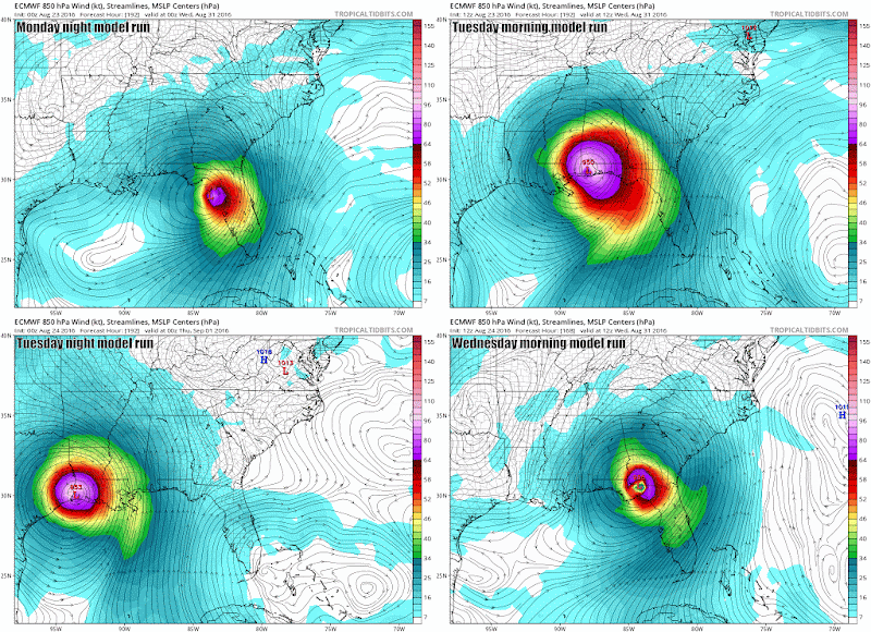
The animated gif below shows the last 4 runs of the Euro model. Notice how the forecasts went from the eastern Gulf in one run to Mobile in the next to the LA/TX border in another and back to the eastern Gulf in the latest. When models are behaving like windshield wipers, that decreases our forecast confidence.


One other thing I would tell everyone to watch. IF '99L' is able to get its act together around the Bahamas and south Florida, the models may be underestimating the strength of high pressure that will be to its north. Weaker high pressure allows the system to turn north sooner while a stronger high would keep it going west longer. As tropical systems intensity, they can sometimes 'feed' high pressure systems or make them stronger than anticipated.

Bottom Line


As it stands as of 3 p.m. on Wednesday afternoon, the overall threat to our area is still pretty low. I've seen some meteorologists saying that posting model runs or discussing scenarios is reckless at this point and just scares everyone. I see it differently.

We are a region that is limping along right now. While the threat is low at this point, potential impacts from this system are now less than a week away should it decide to head this way. Everyone should be prepared just in case and given what we're going through right now, I think an early heads up is needed now more than ever.

Stay safe...stay calm...and we will keep you updated on '99L' which could become Hermine in the coming days.

Tuesday, August 23, 2016

Gulf hurricane talk: fact vs. fiction

A category 5 social media storm hit the internet on Tuesday compliments of a singular run of the European weather model. The run in question shows a likely tropical storm hitting south Florida over the weekend before moving into the Gulf of Mexico and strengthening into a significant hurricane.

Credit: WeatherBell / valid Mon. PM, Aug. 29, 2016

Fact: All we have right now is a poorly-organized tropical wave


The model is developing a hurricane from what stands today as only a very poorly-organized tropical wave with a broad, ill-defined circulation. The Hurricane Hunters confirmed this with a flight on Tuesday, but truthfully, satellite told us all we needed to know about the system at this point.


Fiction: We are certain that the system will develop


The National Hurricane Center is currently giving the disturbance, deemed Invest 99L, a 60% chance of development in the next 5 days. Those are relatively high odds but also represent a 4-in-10 chance that nothing happens with this through the weekend. In the short term, 99L has to fight off wind shear and some dry air. As it eventually gets closer to the Bahamas late in the week and into the weekend, conditions look as though they may be more favorable....IF it survives that long.

Fact: Tropical systems are notoriously difficult to forecast in their formative stages


Until we have an organized area of low pressure with concentrated t-storm activity, take any model projections you see online for 99L with a BIG grain of salt. Models are notoriously bad with both track and intensity in the early stages of development. Michael Lowry with The Weather Channel tweeted a great graphic from the National Hurricane Center that supports this point. 

Credit: National Hurricane Center

The graphic above is limited to systems that have at least become a tropical depression or stronger, so you can imagine with a poorly-organized tropical wave like we have now the error only grows.

Fiction: If 99L does develop, we know where it's going


Most of our forecast guidance is in agreement that 99L should be somewhere in the vicinity of the Bahamas by late this week or this weekend. But while the European model shows a strengthening tropical storm, the GFS never really develops the disturbance.

Should it develop, the European model suggests strong high pressure along the East Coast would leave 99L with little choice but to head westward toward the Gulf of Mexico. However, if we look at the European ensemble forecasts -- 51 runs of the European model with slightly different starting conditions in each run -- you see there's quite the spread on where the center of low pressure associated with 99L may actually go.

Credit: WeatherBell / valid Tues. PM, Aug. 30, 2016


In the map above, each red 'L' represents the forecast location of the low pressure center from a single ensemble member of the European model. Note that the possibilities extend all the way from the Carolinas to Mexico. When we see a map like this, it's an obvious cue that forecast confidence is fairly low at this point.

Bottom Line


Given the historic flooding we've experienced over the last couple of weeks, it is completely understandable that any talk of a tropical system in the Gulf would put us a bit on edge. And, in fact, we all should keep a close eye on 99L in the coming days.

But understand that we are in the formative stages right now and uncertainty is very high on both the future track and intensity of 99L.

In a worst case scenario, impacts to our area would be roughly a week away. However, please remember that odds of this system heading our way are still quite low at this point. Stay alert and follow us in the coming days for additional updates.


Tuesday, August 9, 2016

S. Louisiana Radar Vulnerability Revealed Again Last Week

For the second time in less than 6 months, much of south Louisiana was left without reliable radar coverage in the midst of an ongoing severe weather event last Thursday, August 4th. Big storms rolling through the region delivered a lightning strike to the National Weather Service Doppler Radar in Slidell that took it out of commission for more than an hour.

I previously wrote a detailed post in the wake of the record tornado outbreak in late February about how poor radar coverage and a lack of redundancy may be putting lives at risk in parts of south Louisiana. In the midst of that historic outbreak, a lightning strike also took down out the radar in Slidell. After reading that post, Congressman Charles Boustany and his staff drafted legislation that would attempt to give metro Baton Rouge and much of south Louisiana better radar coverage.

3:18 PM -- Radar down


The National Weather Service sent out notice at 3:18 p.m. on Thursday that the radar in Slidell was down until further notice. While the message below doesn't state it, forecasters quickly let us know in a closed chat room (open to media, emergency managers, etc.) that the culprit was lightning.


~3:30 PM -- Funnel cloud/tornado reported in New Orleans


Roughly 10-15 minutes after lightning took out the radar in Slidell, images and videos quickly started surfacing on social media showing a funnel cloud and possible tornado over New Orleans.

3:35 PM -- Severe T-Storm Warning issued for New Orleans


Minutes after pictures of the funnel cloud and tornado started circulating on social media, the first Severe T-Storm Warning was issued for New Orleans.  In other words, it appears as though the first warning came after the tornado had already touched down and done its damage. And it wasn't a Tornado Warning, but rather a Severe T-Storm Warning relaying the potential for 60 mile per hour winds.


To be fair, post-storm surveys rated the tornado an EF-0, the weakest rating on the Enhanced Fujita scale, with maximum winds estimated around 80 miles per hour. These tornadoes are generally brief and small and can easily escape radar detection. However, I think it's fair to consider whether the radar outage in Slidell hampered the ability of the National Weather Service forecasters to issue warnings in a timely fashion on this storm.

Forecasters were likely monitoring a less powerful terminal Doppler Radar in St. Charles Parish whose primary mission is to cover weather around Louis Armstrong Airport in Kenner, but it's unclear what, if anything, that radar was detecting at the time of the New Orleans storms. Otherwise, the next best view would have come from a radar roughly 125 miles away in Mobile versus 25 miles away in Slidell.

4:12 PM -- Severe T-Storm Warning issued for East Baton Rouge


This one I've referred to as the bogus warning of the day. That's not a slam on my colleagues at the National Weather Service. Rather, with the radar outage in Slidell, there simply is not a good backup view of what's happening here in Baton Rouge. The terminal Doppler Radar in St. Charles doesn't have the range to cover our area. The next closest radars are 120 miles (Fort Polk), 130 miles (Lake Charles), and 180 miles (Mobile, AL) away from downtown Baton Rouge.


Forecasters admitted on that day that the warning was issued out of an abundance of caution given what had already occurred with the severe weather in New Orleans and other storms on the North Shore of Lake Pontchartrain that had produced wind gusts of 55-65 mph. As it turned out, it was more of a garden-variety type storm and I strongly believe would have never received a warning had the radar in Slidell been functioning.

4:39 PM -- Radar returned to service


Hats off to the technicians at the National Weather Service in Slidell who were able to get the radar back online less than 2 hours after it took the hit. However, at this point, the severe weather was essentially ending around the area, meaning the radar was out of service when it was needed most. And at least it was restored quicker than the February 23rd lightning strike which had the radar down for the better part of a day.

But we're back to what I posted about in the wake of the February tornado outbreak. Metro Baton Rouge and much of south Louisiana have relatively poor radar coverage and once the radar in Slidell goes down, forecasters are almost flying blind. That's a scary thought for an area prone to so much active weather.

I hope that this will once again draw some needed attention to our radar vulnerability and help garner some additional support for Rep. Boustany's bill that would attempt to fill in this coverage gap here and elsewhere around the country.

You can track the progress of Rep. Boustany's 'RADAR Act' by clicking here.