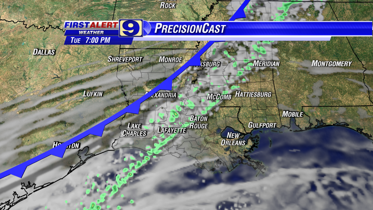
Wednesday, November 12, 2014

Chilly Weather Continues!

By Jay Grymes & Steve Caparotta


WAFB First Alert Quickcast:

- cloudy, damp and chilly into Thursday morning
- slow clearing but staying cool for Thursday afternoon
- FREEZE WATCH for Thursday night into Friday morning

Today was a rather ugly, raw November day under the clouds with occasional sprinkles and passing light rains that kept things just damp enough to add to the air’s ‘winter-ish’ feel. And today was one of those upside-down temperature days, with the high occurring right at midnight with temperatures generally trending downward for most of the day.

The mid- and high-level clouds moving over us from the west and southwest had just enough moisture to occasionally squeeze out a sprinkle or a brief light shower through the day. That will continue tonight and into Thursday morning -- not enough rain to make a difference for the backyard but just enough to require an occasional swipe by the windshield wipers and to keep the air feeling colder than it really is.

Add in a Thursday morning start in the upper 30°s for the Red Stick and you’ve got a classic January morning right in the middle of November. Clouds will start to clear during the latter half of Thursday -- too late to allow for much of a warm-up but soon enough to allow temperatures to start a near free-fall under mainly-clear skies after Thursday’s sunset. We’ll call for a high around 50° for Thursday -- that’s better than 20° below normal for this time of year.

And then? Time for the down comforters and flannel pajamas for Thursday night!

The National Weather Service has issued a FREEZE WATCH for most of the WAFB viewing area for Friday morning -- expect that to be upgraded to a FREEZE WARNING later tonight or early Thursday. We’re calling for upper 20°s for most of metro Baton Rouge and that could mean a couple of WAFB’s communities along and north of the LA/MS state line could sneak down to the mid 20°s.


We are not too concerned about the freeze duration for this event: this will NOT be a “pipe-wrapper” ... but please remember the pets. And what about those extra-tender plants? You may not need to bring them all the way indoors but get them under the carport or under an extended overhang.

After the morning’s “first freeze” of the season, Friday afternoon remains cool under sunny skies. And then here comes another freeze for Saturday morning: not quite as cold, however, with lows around 30° for the Red Stick. Saturday afternoon should be mainly fair with highs climbing to near 60°.

Heading into Sunday, we’ll warm things up considerably as an upper-air disturbance brings Gulf warmth and moisture into the region. Rain is likely for Sunday into Monday: goods news for most of us with the NWS Weather Prediction Center currently suggesting as much as 1” to 2” of rain for most of our area.


Although milder temperatures will come with the rain, we recommend that you keep the winter coats handy for next week. Another shot of cold Canadian air follows behind Sunday and Monday’s wet weather, with another round of freezes in the extended outlook for the early to middle part of next week.

Tuesday, November 11, 2014

Big Chill on the Way!

By Jay Grymes & Steve Caparotta


WAFB First Alert Quickcast:

- front moves through metro BR tonight
- a few light rains, cooler for Wednesday
- Arctic air mass delivers a “first freeze” for many on Friday

After a morning low in the upper 50°s (as we predicted), most Veterans Day ceremonies went off without weather issues. Doppler radar was showing a few pockets of mainly-light showers well west of metro BR during the afternoon and the day warmed considerably, with highs in the upper 70°s to around 80° for many WAFB communities.

A cold front continues to slowly push southward through the Bayou State this evening and overnight, but will still be stretched across the northern Gulf waters on Wednesday. Wednesday morning lows will be near 50° to the low 50°s for most of the WAFB area, running a little higher closer to the coast. But under the clouds and with a colder air mass taking residence, daytimes high only make the mid to upper 50°s. With the front still close and clouds lingering, we’ll keep isolated light rains in the Wednesday forecast -- rain chances for the day will sit around 20% or so, with the best chance for a shower or two coming during the first half of the day. Regardless, whatever and wherever rain does fall, it won’t amount to much and will provide no relief to the dry conditions in the region. 


(We anticipate that the U.S. Weekly Drought Monitor will officially acknowledge the onset of “drought” conditions for portions of the Florida Parishes with its Thursday 8AM release.)

While this mid-week front will be a disappointment in terms of delivering some needed rain, it will make its presence felt when the Arctic air mass behind it fully arrives. Fortunately, this will be more of a sideswipe than a direct hit in terms of a winter chill. We’ve been showing you the plunging temperatures to over parts of the northern U.S. over the past 24 hours, including some locations in the High Plains where temperatures dropped more than 50° in less than a 24-hour period! Thankfully, we’ll have nothing like that.

What we are anticipating, however, is the first fall freeze for much of the northern half of the WAFB viewing area. We’ll call for a sun/cloud mix on Thursday with a morning start in the upper 30°s for metro BR and an even cooler daytime high for Thursday in the low to mid 50°s. As of this afternoon, we’re calling for a Baton Rouge low near or below freezing on Friday morning with lows dipping into the upper 20°s near and north of the LA/MS state line.

We said this cold air episode would be more of a sideswipe rather than a long-lasting direct hit. But it will be cold: many get a freeze on Friday morning and highs on Friday afternoon struggle to reach the 50°s for some of WAFB’s northern viewers. And some of WAFB’s northern communities could flirt with another brief freeze for Saturday’s sunrise. Thankfully, most of us will get back into upper 50°s to near 60° for Saturday afternoon.

Heading into the late Saturday and Sunday, here comes our next frontal system … and this one looks like it has some potential to be a decent rainmaker. A low out of the western Gulf will meet-up with a cold front diving southeastward from the Plains. Based on the current guidance, that is a set-up for rains of an inch or more centered on Sunday. The Plains cold front will also reinforce the cold air that arrives at the end of this week with some potential for another round of light freezes early next week.


We talked about this yesterday, but it is worth revisiting. If Baton Rouge hits freezing on Friday morning, that would be early for the metro area but not something unusually rare. Records back to 1893 for the Red Stick indicate that roughly 1-in-3 autumn seasons record the first freeze on or before November 15th. However, since 1981 (33 autumns) there have only been five seasons with the first freeze occurring by November 15th: that’s a ratio of less than 1-in-6. Indeed, if we look at different periods over the past 100+ years for the Baton Rouge records, we get differing “average dates” for the first fall freeze for the Capital City:

Average
Period Fall Freeze
1901-1930 Nov 28
1931-1960 Nov 20
1961-1990 Nov 26
1991-2013 Nov 26

Global warming? Climate change? Well, yes, even in Louisiana, the climate is always changing. This is also why we can call Thanksgiving Day as the rule-of-thumb date of the average first freeze, since the calendar date for Thanksgiving also changes, ranging from November 22nd to the 28th.

Monday, November 10, 2014

One More Mild Day

By Jay Grymes & Steve Caparotta

WAFB First Alert Quickcast:

- warm, mostly-dry for Tuesday
- scattered light rains for Wednesday
- a real chill arrives later in the week

It was a mighty fine weekend weatherwise, although Tigers and Saints fans aren’t happy at all about the weekend turn of events. At least the Jaguar Nation had something to cheer about! 

Today stayed the course with our dry autumn weather, with a cool morning start and a mild afternoon under sunny skies. However, we are headed into a run of rapid weather chances that began this afternoon and will extended through the weekend. 

Flow off the Gulf has become well established and that means a warmer night and morning start for Tuesday, with patchy fog to begin Veterans Day. Although most memorial services tomorrow should be okay, we can’t rule out an afternoon or evening shower or two -- set Tuesday afternoon rain chances at less than 20% under mostly-cloudy skies. What you will notice on Veterans Day is that the afternoon gets rather warm with many WAFB neighborhoods seeing highs near 80° or more.


Rain chances increase somewhat for Tuesday night into Wednesday, but most of you will be disappointed: even if you get some rain, it certainly won’t be the ‘soaker’ you’d like. Occasional light showers on Wednesday could produce less than 0.1” for most of us with some WAFB communities not getting enough to measure in the raingage. What you will also notice, however, is a big change in temperatures, with Wednesday’s high coming in about 20° (or more) lower than Tuesday’s high. With the clouds and occasional showers, Wednesday is shaping up to be a rather disagreeable day: cool and dampish, even though rain chances through the course of the day will be only about 30% or so.

By Thursday, the chill really begins to arrive. Thursday morning begins with lows in the upper 30°s to low 40°s for most WAFB areas, with daytime highs struggling to make it into the mid 50°s for the Red Stick under partly cloudy skies. And by Friday’s sunrise, about half of the viewing area could be near or below freezing!

If Baton Rouge hits freezing on Friday morning, that would be early for the metro area. Uncommon but certainly not rare: a look back in the record books shows that Baton Rouge has reached 32° (or below) by or before mid-November on about 1-in-4 years, on average. As a matter of fact, BTR’s first 32° last fall arrived on November 13th (and, if you remember, temps dropped into the 20°s for the last three days of the month – now THAT was unusual). 

However, as we’ve mentioned in the past, the “average date” of the first fall freeze for Baton Rouge arrives around the last week of November. The statistical date in on or about November 27th based on data since 1981. However, for the trivia lovers, that date does move ahead by a few days (earlier in the month) if we choose to include more pre-1981 years. For an easy, rule-of-thumb reference, we can use Thanksgiving Weekend as a rough guide to the timing of the “average” first freeze for the Capital City region. (Of course, the date is earlier for locations north and east of Baton Rouge, and later as you head to the south of BTR.)

After the cold start, highs on Friday remain in the 50°s although it should be a mainly sunny day. Then most of us return to a high near 60° for Saturday with the coldest part of the northern air mass missing the Gulf Coast this go-around (Note to media: STOP! With the ‘Polar Vortex’ noise, please!).


Our next front is currently scheduled to arrive on Sunday, and the early signs are that Sunday’s front delivers a decent rain. Let’s hope so! 

All quiet in the tropics …

Friday, November 7, 2014

Cool, Dry into the Weekend

By Jay Grymes & Steve Caparotta

WAFB First Alert Quickcast:

- dry through the weekend
- a little warmer early next week
- waiting on some rain

We started the day much cooler under clear skies with most WAFB neighborhoods slipping to the mid and upper 40°s for this morning’s sunrise.  A north to northeast breeze and occasional high clouds helped keep today’s highs in the low to mid 60°s for most of us in spite of the mainly sunny skies.


We’re expecting a few more clouds later tonight but not enough to stop an even larger drop in overnight area temperatures: plan on a Saturday sunrise in the low 40°s for metro baton Rouge, with some upper 30°s possible for some of our northern viewers.  Skies on Saturday should be generally fair for much of the morning, becoming partly cloudy into the late morning and afternoon.  We’re looking for mid-afternoon highs in the upper 60°s for the Red Stick. 

We’re still expecting a ‘dry’ front to slide through the viewing area Saturday evening: that’s the source of some of the late day clouds.  But rain with Saturday’s front?  Not a chance: bad news for those looking for a garden soaking but great news for the LSU Tiger faithful and the Jaguar Nation as the Red Stick hosts two big college home games on Saturday night.


The front clears the coast by early Sunday morning, having very little impact on our weather.  We expect Sunday morning lows in the low 40°s for metro Baton Rouge with afternoon highs in the upper 60°s to around 70° -- about 5° or so below the official norm but still quite pleasant under mainly sunny skies.

A modest warming trend sets in for Monday and Veterans Day (Tuesday) as most of us sit back and wait on some much-needed mid-week rains.  Our next fall front is scheduled for arrival in the Bayou State sometime late Tuesday into early Wednesday.  We’ll go with rain chances for the WAFB viewing area at about 20% for the latter half of Tuesday then call for scattered rains on Wednesday.

But … once again, the current extended range indicators are not very promising in terms of next week’s front being much of a rainmaker.  That outlook could change between now and then, but we aren’t very optimistic at this stage.  It looks like the front slides through without much in the way of rainfall, then stalls over the northern Gulf.  That leaves us with the hope of some ‘backside’ rains (light to moderate rains to the north of the surface front, sometimes called “overrunning” rains); however, those rains don’t look all that productive either.


Let’s face it: dry weather in the fall is welcomed by many -- like football and festival fans.  For farmers, it’s a bit of a mix: many are pleased by a run of dry weather that provides for efficient field work, especially for the sugarcane community at harvest time.  However, for others, the dry weather has stunted grass growth, leaving some pastures in fair to poor shape for livestock.  What’s more, we’re seeing some residents pulling out the sprinklers for the dry lawns and landscaping.  Without doubt, soil moisture conditions are becoming a little too dry across most of our viewing area and without any significant relief soon, we’re anticipating the U.S. Weekly Drought Monitor experts to officially post areas of drought for portions of southeast Louisiana next week.​

Meanwhile, it’s all quiet across the tropical Atlantic.​

Thursday, November 6, 2014

Cooler into the Weekend

By Jay Grymes & Steve Caparotta


WAFB First Alert Quickcast:

- continued clearing tonight, much cooler for Friday AM
- cool and dry weekend ahead

As expected, we had a little fog and a few lingering showers for the early morning commute. Although we did see a blip or two on radar into the afternoon, just about all of the rains ended across the viewing area by the mid-to-late morning. In fact, there were occasional peaks of sunshine during the afternoon but a fairly dense deck of clouds remained over most of the region through the afternoon and into the early evening. After a mild morning start in the 60°s, the cooler air behind the front combined with the day’s clouds to keep highs for a majority of WAFB neighborhoods in the low 70°s.

Skies will clear into the evening and overnight, with Friday morning temperatures dropping into the mid 40°s for metro Baton Rouge. Highs on Friday will reach the mid 60°s for most of us as the northerly winds deliver a cooler and less humid continental air mass to the Gulf Coast region. It will be a mostly sunny day, with occasional thin, high clouds sliding in from the west.

Our forecast remains dry through the weekend. Expect Saturday morning lows in the upper 30°s to low 40°s for much of the WAFB viewing area with Saturday highs in the mid to upper 60°s under mostly sunny skies. We still anticipate a weak, dry cold front to move into the lower Mississippi Valley early Sunday morning, but the most that the weekend front does is generate some cloud modest cover: we’ll call for partly cloudy skies from Saturday evening into early Sunday with Sunday sunrise lows in the low 40°s for the Red Stick. By Sunday afternoon, it’s back to mainly sunny skies with highs in the mid to upper 60°s for most of our viewers.

A brief warming trend early next week takes afternoons back into the 70°s for Monday and Tuesday ahead of the next anticipated cold front. We’ll go with a 20% to 30% rain chance for Tuesday afternoon and early evening -- Veterans Day -- with scattered showers and maybe a few rumbles of thunder for Wednesday. For now, next week’s front looks “wetter” than what we saw last night and early this morning ... but confidence is not all that high, especially given our dry trend that has persisted since the start of September.


And without doubt, many people are disappointed with the paltry rain totals that most of us received during the last 24 hours. As we anticipated, the larger rain totals in our viewing area were generally to the north, northwest and west of the Capital City, but even those were below one-quarter of an inch in almost all cases. And as expected, rain totals trended downward to the east and southeast of the metro area. While we did find a couple of sites that reported 0.2” or more, the majority of locations came in at under a tenth of an inch … with a number of raingage sites reporting no “measurable” rainfall -- in other words, a ‘trace’ at most with some sites reporting no rain whatsoever.

That is NOT what the (lawn) doctor ordered!

Meanwhile, nothing of any concern in the tropical Atlantic as the official hurricane season (ending November 30th) continues to wind down.

Wednesday, November 5, 2014

Rain Tonight, Cool & Dry Weekend

By Jay Grymes & Steve Caparotta


WAFB First Alert Quickcast:

- mainly light rains later tonight and early Thursday
- cooler, stays dry for Friday & the weekend

The front that we’ve been waiting on all week finally gets here by early tomorrow morning. Unfortunately, if you were expecting -- or hoping for -- a good soaking, it looks like you are out of luck. Today’s rains over East Texas have been less than impressive ... and the system will weaken even more before getting into our area. 

We’ll call for scattered rains tonight, with most of them on the ‘light’ side. If some of us do hear a rumble or two of thunder, they will certainly be very few and far between. We expect to see rain totals show a tapering trend from west-to-east: the way things are looking right now, you’ll be lucky to get as much as one-tenth of an inch of rain between now and Thursday morning. 


In fact, some of you may see little more than a sprinkle and there will be those with little or no rain whatsoever, especially to the southeast and south of metro Baton Rouge.

Not what most of us were hoping for -- and this could set the stage for a downgrade to “official” drought conditions (based on the U.S. Weekly Drought Monitor) for some WAFB communities by next week. If we don’t get any significant rain in the next 12-24 hours, the next chance of measurable rain doesn’t appear until almost the middle of next week.

The front looks like it slips through metro BR near or just a little before sunrise. So some of us should expect scattered light rains for the morning drive with the rains coming to an end for all WAFB communities by mid-morning or so. We’re posting Thursday morning lows for the Capital City region in the low 60°s. Skies will slowly clear through the day, with highs reaching the mid 70°s for Baton Rouge.

Skies should be just about completely clear by Thursday evening, allowing for a substantial cool-off overnight and into early Friday. We’re calling for a Friday morning start in the mid 40°s with sunny skies and a high on Friday in the mid to upper 60°s -- definitely cooler ... but not a true Canadian blast. We’ll stay with lows in the low to mid 40°s for Saturday and Sunday mornings with highs in the mid to upper 60°s for both days.

A follow-up, weak front slides through the lower Mississippi Valley late Saturday into the early hours on Sunday, but it will only have a limited impact -- a few clouds for Saturday evening and overnight into early Sunday with maybe a drop in temperatures of one to two degrees for Sunday, but that’s about it. We’re not expecting any rain with that weekend frontal passage.


Highs return to the 70°s for early next week, with limited rain chances currently posted for the next anticipated front -- late Tuesday into early Wednesday.

Monday, November 3, 2014

Warming Trend Continues on Tuesday

By Jay Grymes & Steve Caparotta


WAFB First Alert Quickcast:

- staying dry through Wednesday morning
- frontal rains late Wednesday into early Thursday

Okay .. it may take a few days to get used to the fact that it’s dark by the 6PM newscast ...

Today marked three straight days with morning lows in the 30°s for much of the WAFB viewing area ... although a look back at regional reports shows that just about everyone dodged the freeze on Sunday morning.


We say ‘goodbye’ to the 30°s for a while -- in fact, this afternoon began a mini-warming trend that lasts through Wednesday. After this morning’s low in the upper 30°s for Baton Rouge, tomorrow starts out with lows in the 50°s and we're expecting morning minimums in the 60°s for many WAFB communities by Wednesday. We’re calling for Baton Rouge area highs in the upper 70°s for Tuesday under a sun/cloud mix and highs up in the upper 70°s to around 80° for Wednesday.

It looks like our prolonged run of rain-free days will come to an end on Wednesday and Thursday as our next front pushes through the viewing area. Frankly, most of us can use a good rain, so the expected 0.5” to 1.0” rains will be welcomed. We’ve got the rains moving into the area during the latter half of the day on Wednesday and extending into Thursday morning. The models are still struggling a bit with the exact timing, in part because the front looks like it will slow its forward progress as it approaches the lower Mississippi River Valley.


That loss of forward momentum looks like it will be accompanied by a loss in frontal energy, accounting for the relatively modest rain totals that we are currently projecting. In addition, at least for the time being, the loss of energy will mean little in the way of active or severe weather. We won’t rule out a few thunderstorms as the front works its way across the region but nothing widespread -- we don’t anticipate any watches for our area at this time. (Of course, we’ll keep an eye out for any changes.)

The rains could linger into Thursday’s morning commute but skies should begin clearing by the latter half of the day. Friday will be cooler, but not a major cool-down like we saw over the past weekend.


Another front makes its way through the region late Saturday into early Sunday. We won’t say “no rain” with the weekend front but it looks like it will be a mostly-dry passage that simply reinforces the cooler air that arrives on Thursday and Friday. And so, in case you are wondering, the weather is looking pretty good in ‘Death Valley’ for Saturday Night (LSU vs. Alabama) and ‘Up on the Bluff’ (Southern vs. Texas Southern) -- only a very slight chance of an evening shower under otherwise partly cloudy skies.

All quiet in the tropics …