Wednesday, April 30, 2014

Cool Start to May!

By Jay Grymes & Steve Caparotta


WAFB Storm Team QuickCast:

- on the ‘cool’ side for Thursday & Friday
- looking fine for the weekend

How today’s sun-up? Lows in the upper 50°s for many with some mid 50°s to start the day up along the LA/MS state line. And as promised, the cooler-and-less-humid air from the northwest made for a nice afternoon for most of us, although some mid-level clouds and a broken band of light showers did sneak into the area from the southwest during the mid- to late-afternoon hours. Still, the vast majority of us stayed dry with highs topping out in the low to mid 70°s. Not a bad way at all to close out April.

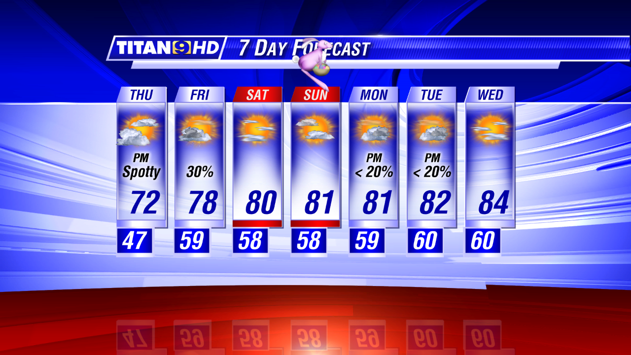
And May starts out pretty sweet too. In fact, many WAFB neighborhoods will awaken to morning lows in the upper 40°s: the kids may need a jacket for the bus stop. If you're wondering, we'll not quite set a new record for May 1 -- the record low is 45° -- but we will get close. And our forecasted high for Thursday will only make the low 70°s for Baton Rouge, roughly 10° below normal. Add in the low humidity and you've got a wonderful spring day ahead.

It's back into the upper 40°s to low 50°s for most of us on Friday morning too. Some of our guidance is hinting at a slight chance for a passing shower or two on Friday, so we'll toss in spotty showers for Friday morning into the afternoon, but like today, most of us stay dry. We’ll expect highs in the mid to upper 70°s under otherwise partly cloudy skies. Even those that get a shower on Friday will see little more than a sprinkle – no problems at all for Friday's 'Live After Five' in downtown BR. 


And the weekend looks just great. It will be a little warmer, with morning minimums in the 50°s and afternoon highs in the low to mid 80°s for both days, but Saturday and Sunday will be 'sunscreen' days under mainly sunny skies. Good stuff to get outdoors!

Our forecast remains dry through the remainder of the 7-day outlook.


In fact, if there is a complaint, it would be the lack of rain over the past few weeks. While April rain totals across the WAFB viewing area are typically in the 3” to 5” range, almost all of that fell during the first half of the month at most sites. While no one wanted monthly to see the severe weather develop that threatened the area earlier this week, we certainly could have used a good widespread rain. 

We’re not approaching a “drought threat” just yet, but you may want to consider watering those spring gardens and re-worked backyard landscaping in the coming days given our dry forecast into next week.

Tuesday, April 29, 2014

Clearing, Less Humid for Wednesday

By Jay Grymes & Steve Caparotta

** TORNADO WATCH ** for many until 9PM

WAFB Storm Team QuickCast:

- rains ending tonight, clearing through the morning
- a few sprinkles for Friday, fair through the weekend

The northern half of the WAFB viewing area remains under a TORNADO WATCH until 9:00pm. Our warm-and-muggy air mass is the fuel for the severe-weather threat but through 4:00pm we’ve only seen a couple of clusters of storms across the viewing area. What we do know is that if a storm can get going in the next couple of hours, it has the potential to quickly become severe -- that’s exactly what we saw during the mid-afternoon that prompted a Severe T-Storm Warning over northern EBR, southern E-Feliciana and St. Helena parishes.


But “warmth” at the mid-levels of the atmosphere -- and a relatively slow rate of warming through much of the afternoon kept us from dealing with a more significant outbreak -- at least so far. Many of us did reach the upper 80°s by the late afternoon - - generally warm enough to provide lift to power-up a few storms, that’s why we still might see a strong storm or two between now and 7:00pm.

However, we’re thinking that once we reach sunset, the severe threat will decline through the rest of the night. We’ll go with isolated t-showers into the evening, with most or all of the rain out of the viewing area by or before midnight. The exception will be along the coast, where the opportunity for showers and a few storms will extend into Wednesday morning.

The front will finally slide through the area tonight, with the accompanying wind shift marking a dramatic change to the local air mass: northwesterly flow behind the front will deliver much drier (“less humid”) and much cooler air. In fact, many WAFB neighborhoods will awaken to sunrise temperatures in the upper 50°s under mainly fair skies for Wednesday!

Plan on mainly sunny skies throughout Wednesday. After that cool start to the day it just gets better, with “dry” air and highs only getting into the upper 70°s for the Red Stick. How about lows in the upper 40°s to low 50°s for Thursday morning and a Thursday high in the low 70°s under mostly sunny skies? Sounds good.

Friday starts off cool too: sunrise in the low 50°s with afternoon highs in the mid 70°s. A weak disturbance prompts us to put in a very slight chance of afternoon showers in the Friday outlook -- at less than 20% -- just not enough to worry about. And the weekend? Looking great -- mainly sunny skies both days with morning starts for Baton Rouge in the 50°s and afternoons in the low 80°s.


Is there anything to complain about? Not really, although some of you could use a little rain. But with our mostly-dry outlook through early next week, you might need to water the garden in the coming days.

Saturday, April 26, 2014

Sunday's Forecast & Early Look at Work Week Storm Potential

Sunday is shaping up to be a "decent" weather day.  Most will stay dry as we only see a spotty shower or two Sunday morning mainly north of Baton Rouge and iso'd afternoon showers across the entire WAFB viewing area.  The bigger weather issue may in fact be winds.  Windy conditions will continue Sunday with gusts as high as 30-35 mph.

The winds are in response to an approaching storm system.  This storm system has become a national story because of its potential for severe weather across many states over many days.

Severe Weather Risk 7 AM Monday - 7 AM Tuesday

The Storm Prediction Center is responsible for issuing the official risk for severe weather.  Saturday through Wednesday SPC has issued a slight risk for severe weather for 22 states.  The graphic above depicts the risk for severe weather from Monday morning into Tuesday morning.  The entire WAFB viewing area is under a slight risk for severe weather.  The moderate risk (red oval) stays well to the north.  The best chance we see anything on the strong to severe side would be late Monday (7PM) into early Tuesday (7AM).

Severe Weather Risk 7 AM Tuesday - 7 AM Wednesday

During the day on Tuesday the risk of severe weather stays in parts of the viewing area.  This will be as a cold front moves through the area.  The threat for severe weather ends for good once the front moves through which should be Tuesday evening.

As of today the forecast doesn't look very bad for SE Louisiana as it pertains to severe weather.  We look to have a decent cap to the atmosphere which would inhibit strong t-storms from forming.


Rising warm air helps to create energy for storms.  If a layer of warm air sits atop a shallow layer of cold air this starves storms of possible energy.  *At this time* this cap is expected to exist Sunday and again on Monday.


On Tuesday once the cold front gets a little closer it should erode the cap on the atmosphere.  That doesn't mean we are guaranteed to see any severe weather, just that the possibility will exist with other needed factors present.

With this event still a few days out things can easily change.  So stay tuned for future updates.

Friday, April 25, 2014

Warm, A Few Showers for the Weekend

By Jay Grymes & Steve Caparotta


WAFB Storm Team QuickCast:

- warm & breezy but a good-looking Saturday
- isolated afternoon showers for Sunday
- strong cold front and severe weather threat for Monday/Tuesday
We saw little in the way of showers even with the cool front draped across southern Louisiana this morning.  That same front remains over the southern parishes this afternoon and is trying to work a little farther to this south.  If it can, that should yield mainly-fair skies and a slight dip in the humidity by the evening hours.  So it’s “All Good!” with a nice Friday evening for downtown’s Live After Five (featuring Marcia Ball) or dinner-and-a-movie.
Unfortunately, rather than sweeping out over the Gulf, today's front will start drifting back to the north as a warm front.  Just when then northbound retreat begins -- and how far north it gets through the overnight hours -- will have a great deal to do with Saturday's sunrise weather.  While Saturday will remain mainly-dry no matter what happens with the front, an earlier return north will mean a "warmer and muggier" morning start for metro Baton Rouge with clouds and some patchy fog.  A farther drift to the south tonight and a slower return to the north through the morning will mean a slightly cooler start for Saturday under mainly fair skies.
For now, we'll split the difference for Baton Rouge's Saturday wake-up: let's call it partly cloudy with patchy fog (especially over the more southern parishes).. Morning lows are likely to be in the 60° to 62° range – so it’s looking good for the American Heart Association's 'Heart Walk' tomorrow morning at the LSU Old Front Nine.  But by Saturday afternoon, you'll likely notice a slow rise in our humidity.  In addition, it gets a little breezy for the afternoon under partly-cloudy skies with highs in the low to mid 80°s for the WAFB viewing area.  So maybe not perfect spring weather ... but no complaints either!

More Humid, A Few Showers by Sunday

Gulf humidity will be back in full-effect for Sunday thanks to a steady flow off the Gulf.  Sunday will open with low clouds, areas of fog and morning starts in the upper 60°s -- quite muggy for this time of year.  The warm, moist Gulf air will take afternoon highs back into the low to mid 80°s once again.  Skies will range from a sun/cloud mix early in the day to a mostly-cloudy afternoon.  In addition, we've been talking about isolated (20%) showers for Sunday for much of the week; now we'll call it a 20% to maybe a 30% rain chance for the afternoon and early evening given the unstable Gulf air mass in place.  Still, it doesn't look bad at all for downtown's Louisiana Earth Day celebration (Sunday, Noon to 8:30pm).
Over the weekend we'll also be watching a storm system strengthening over the Central and Southern Plains.  We've mentioned this for a few days now as the NWS Storm Prediction Center (SPC) anticipates this to be a rather potent frontal system generating strong-to-severe storms as it marches east.  By late Sunday into early Monday, the SPC has a "Slight Risk" for severe weather posted for the northern half of Louisiana, with an area of "Moderate Risk" centered around the ArkLaTex.

Showers & T-Storms Early Next Week

We're still working on the details of the timing for our local communities, but it looks like the main threat for severe weather for WAFB-land will be during the latter half of Monday into Tuesday.  Note, however, that the latest projections from the NWS -- as well as indications from our ‘better’ extended range models -- are now showing a slower-moving system than previously thought.  This suggests that the rains and storms across the WAFB viewing area could continue much later into Tuesday than we had been thinking.  In fact, the NWS Weather Prediction Center (WPC) outlook suggests that the cold front may still be draped along the state's southeastern coast as late as Wednesday morning.
But the key story here remains the severe weather threat that arrives ahead of and along the front, with all modes of active weather on the table: damaging winds, large hail and tornadoes.
Heavy downpours will also be a local nuisance, with the latest WPC projections calling for 1" to 3" of rain (from late Sunday into early Wednesday) across the northern half of our viewing area.  However, most of our local rivers and tributaries are at levels that these rains should not produce any significant waterway flooding -- as long as these rain estimates are somewhere in the ballpark of what actually arrives. 
And lastly, power outages will also be a concern with these storms: now is a good time to check the batteries in your NOAA Weather Radio and your flashlights too.
A Pacific air mass on the heels of next week's system will deliver some nice weather and noticeably cooler temperatures for the second half of the week.  We can expect morning lows in the 50°s, possibly as early as Wednesday morning, with highs in the 70°s for Wednesday, Thursday and Friday.  And for the time being, some of the longer-range tools are suggesting mild weather continues right into the following weekend.

Thursday, April 24, 2014

Isolated Showers for the Weekend

By Jay Grymes & Steve Caparotta


WAFB Storm Team QuickCast:

- patchy fog and isolated mainly-light showers for early Friday AM
- partial clearing for Friday afternoon, looking good for Saturday
- spotty PM showers for Sunday
- stormy weather late Monday/early Tuesday

We opened the day with widespread fog, including some pockets of locally-dense fog in a number of places. In fact, areas on the west side of the Atchafalaya Basin were under a Dense Fog Advisory earlier this morning. But other than the morning fog, today turned out to be another nice spring day under partly cloudy skies with highs again climbing into the mid 80°s for most WAFB neighborhoods.

The Gulf air mass currently extending over our region has dew points in the upper 50°s to low 60°s. They are likely to stay there through Friday morning, so be ready for another round of fog for tomorrow morning with sunrise temperatures in the low to mid 60°s for metro Baton Rouge. Our Friday forecast still calls for the passage of a trailing cool front through Louisiana during the day, but as we mentioned a number of times this week, any active weather associated with the front will stay to our north. We'll toss in a slight chance of rain for Friday morning -- at 20% or less. Skies are expected to be mainly-fair by the late afternoon and evening, so it's a "thumbs-up forecast" for Friday's Live After Five.


Our Saturday forecast has improved a bit. Although afternoon temperatures won't show much of a change, the air mass behind Friday's front should be slightly "drier" (less humid), and that takes just about any chance of rain out of the forecast for the day. Fog shouldn't be any kind of a problem for Saturday morning either as we start the day in the upper 50°s to low 60°s. Saturday afternoon highs will return to the mid 80°s under fair to partly cloudy skies. But the “drier” air doesn’t last long: we're keeping a 20% chance of rain in the Sunday forecast as low-level Gulf humidity slowly creeps back into the area with southeast and southerly breezes. 

You have to admit, it's been an agreeable week and weekend for those enjoying Spring Break.

Our forecast into next week still has a more potent front passing through our area early Tuesday, bringing not only rain but a threat of active-to-severe weather. Even this far ahead of time the NWS Storm Prediction Center is noting a severe weather threat for the lower Mississippi River Valley from late Monday into early Tuesday, with the potential for strong tornadoes developing ahead of and along the advancing cold front. 


It's still a little too early to become overly-concerned about a severe weather threat for early next week, and we've got several days to work out the particulars -- just keep it in mind. Of course, the WAFB Storm Team will keep a close eye on developments through the weekend -- follow us on-air and on social media.

Wednesday, April 23, 2014

Breezy & Warm on Thursday

By Jay Grymes & Steve Caparotta


WAFB Storm Team QuickCast:

- another nice spring day for Thursday
- isolated afternoon showers for Friday, Saturday & Sunday
- bigger weather threat by late Monday

The forecast for the rest of the week is holding together as expected, with a good-looking spring day today and another on the way for tomorrow. We'll keep patchy fog in the Thursday morning forecast, with another mostly-sunny to partly-cloudy afternoon on the way as highs return to the low to mid 80°s for just about all WAFB communities.


Weekend Outlook


Our forecast for Friday through Sunday remains the same too: morning starts in the mid to upper 60°s with patchy fog around sunrise and highs in the mid 80°s with isolated afternoon showers. With rain chances for each of those days at only 20% or so, it means that most neighborhoods will stay dry each afternoon and even the rains that do develop will likely be short-lived. All looks pretty good for downtown Baton Rouge's Earth Day festivities on Sunday.


As we showed you yesterday, a warm front will continue it's northward drift through the state tonight and tomorrow. The front won't have enough energy or upper-level support to do much more than generate some fair-weather clouds, but it will signal a slow-steady increase in low-level moisture (rising dew points) that will mean warmer-than-normal mornings in the 60°s and provide the main ingredient for each morning's patchy fog. Still, dew points in the 60°s are not truly "uncomfortable," so while the next few afternoons will be warm, they should be nice days for some time outside.

While all will be relatively quiet here through the weekend, we will be watching some more active weather to our northwest and north over the next five days. The good news is that everything points to this week's active-to-severe weather remaining to our north and west through Sunday. Even some north Louisiana parishes may get in on some regionally-active weather tomorrow, but southern Louisiana and SW Mississippi should stay in the clear.


More Active by Early Next Week


Early next week, however, looks like a different story. 

Models continue to show a fairly potent frontal system moving into the central Gulf Coast region on a late-Monday to early-Tuesday time frame. Storms associated with the system will be developing over the Central and Southern Plains during the weekend as it marches east. A preliminary assessment by the NWS Storm Prediction Center already has much of the WAFB viewing area posted with at least a 30% chance of severe thunderstorms as the cold front moves through. 


We'll be keeping a close eye on further developments in the coming days, remembering that this is the 'heart' of severe weather season for our region.


But for the time being, let's just smile at the good spring weather as most of our kids enjoy their spring break from school.

Tuesday, April 22, 2014

Staying Warm, Mainly Dry

By Jay Grymes & Steve Caparotta


WAFB Storm Team QuickCast:

- clearing skies tonight, patchy light wake-up fog for Wednesday
- warm & dry for Wednesday and Thursday afternoons
- slight rain chances (20% or less) for Friday through Sunday

As we mentioned during yesterday's evening weathercasts, the 'cool' front that is pushing to the south and southeast through the state this afternoon and evening doesn’t have a whole lot of "punch" to it, barely generating so much as a shower in the region this afternoon. What's more, while we are calling it a ‘cool front’ it will make very little difference in our local temperatures and humidity. 

With most spring fronts traveling through the central Gulf Coast area from the west and northwest, we usually feel a welcomed drop in both dew points (humidity) and temperatures after the front moves through. But that's not going to be the case this time around. In fact, while our regional dew points may briefly drop a degree or two on Wednesday, the day will be as warm, if not warmer, than today. 

Whatever is left of today's front may back-up as a warm front on Wednesday, with warm and slightly-humid Gulf air settling over the Bayou State for the rest of the week. Yet even if the front retreats northward on Wednesday it won't have enough energy and mid-level moisture to do more than generate a few fair-weather clouds. We're expecting a mostly sunny Wednesday afternoon -- another fine outdoor "play day" for those youngsters enjoying a week off from school.

Our forecast headed into the weekend hasn't changed either from yesterday. We'll go with lows in the 60°s for the mornings with patchy wake-up fog and low to mid 80°s for the afternoon highs through Sunday. 


We’ll enjoy partly cloudy skies on Thursday. However, by Friday and the weekend, our daytime warm-ups will combine with the moisture from the Gulf air in place, resulting in spotty-to-isolated afternoon showers for all three days. Any showers that do develop should be short-lived, and while one or two may generate some claps of thunder, all three days should be fairly good days for some outside fun. With rain chances at 20% or less for each of the afternoons, there’s no reason to be concerned about any outdoor plans.

Into next week, our two favorite extended outlook models -- the GFS and the 'Euro' -- are still indicating the arrival of our next spring front on a Monday/Tuesday timeframe. Both models seem to suggest a slightly later arrival than they did yesterday and both models also suggest that this will likely be a more 'active' frontal passage than what we saw today. It is still a little too far off to nail-down the exact timing or the severe weather potential, but keep it in mind for any plans you might be making for next Monday evening.

Friday, April 18, 2014

Good-Looking Easter Weekend!

By Jay Grymes & Steve Caparotta


WAFB Storm Team QuickCast:

- a few showers/storms this afternoon & evening, clearing skies tonight
- nearly-perfect spring weather for Saturday and Sunday
- good-looking weather for most of the coming week

It was a mild night and morning start as clouds helped keep the morning lows in the upper 50°s to low 60°s for most WAFB neighborhoods. And as expected, we enjoyed some nice breaks in the clouds through Good Friday even with the slight chance of showers that persisted throughout the day.

The day’s spotty showers were the product of two larger-scale features: a weak eastbound mid-level disturbance to our north and back-side wrap-around circulation associated with the intensifying storm system to our east. Individual cells within that wrap-around flow were drifting along a general north-to-south track and produced a few flashes of lightning and rumbles of thunder around the viewing area during the afternoon, but nothing serious or ‘severe.’

These pop-up thundershowers could make things a little dicey for this evening's "Live After Five." But by later this evening, everything clears out, leaving us with a fine Easter weekend ahead.


We're expecting morning starts in the 50°s and mostly-sunny to partly-cloudy afternoons with highs around 80° or so for both Saturday and Easter Sunday. Dew points will be in the low to mid 50°s for most of us throughout the weekend, indicating a fairly "dry" (non-humid) air mass in place.

Frankly, it doesn't get much better than this, so try to get outdoors and enjoy! Sunrise services and Easter morning egg hunts should go off without any nuisances from Mother Nature!

The nice spring weather holds throughout the better part of the upcoming work week too! We'll toss in a slight chance of rain for Tuesday -- at 20% or so -- with afternoon highs in the 80° to 83° range for the Red Stick just about all week long. Towards the week's end, we'll see another chance for afternoon showers and a few storms, but as of right now, it's a pretty good 7-day outlook. You might notice a slight rise in the humidity as the work week progresses, but nothing that feels truly muggy. 


With just about all area schools having an extended break this coming week, you couldn't ask for a much better run of days for the youngsters!

Happy Easter from the entire WAFB Storm Team!

Thursday, April 17, 2014

Looking Good by the Weekend!

By Jay Grymes & Steve Caparotta


WAFB Storm Team QuickCast:

- scattered, mainly-light showers tonight and early Friday
- spotty light showers for Friday afternoon 
- looks great for the Easter weekend!

The disturbance over the Gulf of Mexico snuck a little farther north this afternoon than we had expected, helping to generate our afternoon overcast and delivering showers along the Louisiana coast for much of the afternoon. While we’ve even seen a few flashes of lightning to our west in Acadiana and out over the coastal waters, most of the rains across the southern parishes have been rather light, and we expect that rains will stay that way into the evening and overnight.

So yes, we will carry a chance of rain in the Friday forecast, calling for scattered, mainly-light showers for metro Baton Rouge for this evening, overnight and into early Friday morning. Rain chances will be a bit higher closer to the coast, especially areas east of the Atchafalaya Bay. By contrast, rain chances decrease as you move north and west of the Capital City.

By Friday noon, we’re dropping rain chances to less than 20% (“spotty”) for most WAFB communities. That means someone may see an afternoon shower or two, but again, whatever does fall will be rather light and probably not very long-lasting. We can’t entirely rule out a passing shower for Friday’s “Live After Five” but the odds look pretty good that the downtown music fest goes just fine.


As for the Easter weekend, our forecast seems to get better with each passing day. We’ve essentially taken any chance of rain out of the forecast for both Saturday and Easter Sunday, with morning starts in the 50°s and afternoon highs around 80° for both days. Saturday looks nearly perfect for mid April. And whether you’re headed to Easter sunrise services, a mid-morning Egg Hunt, a backyard boil, or just enjoying family and friends, we think you’ll be mighty pleased with Sunday’s weather too.


Our forecast calls for a very modest warming trend through the coming seven days. By early next week, morning starts will be near or even above 60° with afternoon highs climbing into the low 80°s -- temperatures that will be just a tad above the norm but nothing to complain about. We do have a slight chance of rain for Tuesday, but other than that the days look mainly-dry into the middle of next week, at least.


Wednesday, April 16, 2014

Warmer into the Weekend

By Jay Grymes & Steve Caparotta

WAFB Storm Team QuickCast:

- warming trend underway with 80°s by the weekend

- mainly dry Thursday, a few showers possible for Friday

- Easter weekend looks good
Yep!  Metro Airport set a new record low this morning, but it wasn’t just a record for today.  This morning’s 37° for Baton Rouge is the lowest reading ever after April 15th, based on all the observations dating back to the Spring of 1893 -- that’s more than 120 years!
So here’s the key take-away: we should now be able to say “Goodbye!” to the 30°s until sometime late in the Fall of 2014.  Enough of winter, please!
Our daily temperatures for Thursday will still end up below seasonal norms, but a warming trend has already begun after the cool weather over the past 36 hours or so.  Although we only reached the mid 60°s at Metro Airport this afternoon, that’s still a little warmer than Tuesday afternoon.  And tomorrow morning’s low for metro Baton Rouge should be about 10° higher than this morning’s record low.  We’ll get into the low 70°s for Thursday afternoon and by Friday, wake-up temperatures will be in the upper 50°s to near 60° for the Red Stick with afternoon readings climbing into the upper 70°s.
While a spotty shower or two for Thursday can’t be totally discounted, most stay dry through the day.  For Friday, we’re posting a 30% rain chance for the region -- but even for Friday, any rain that does fall should be relatively modest and short-lived.  All in all, it looks good for Friday’s “Live After Five” with temperatures during the outdoor concert in the 70°s under a sun/cloud mix.
Maybe of greater importance for most of us is the “improved” weekend outlook.  Yesterday we were calling for isolated showers possible for both Saturday and Easter Sunday.  But our guidance today paints an even better-looking weather picture.  A rogue shower can’t be completely ruled out for either day, but both afternoons should be warm and mainly-dry across the area.  Get ready for those Easter Egg Hunts!
We’ll call for isolated mainly-afternoon showers for Monday and Tuesday, with fair to partly cloudy skies for Wednesday. 

Tuesday, April 15, 2014

Record Lows Likely on Wednesday Morning!

By Jay Grymes & Steve Caparotta


WAFB Storm Team QuickCast:

- record low on the way for Wednesday’s sunrise!
- warming trend through the rest of the work week
- adding very modest daily rain chances for Thursday through Sunday

After last night’s storms, the cold and dry Canadian air mass behind the passing cold front delivered a sunny but windy and cool Tuesday with highs struggling to make the 60°s. For many of us today ‘felt’ cooler than it really was. 

However, the bigger weather story arrives tomorrow morning. We’re posting a forecast low of 36° for the Red Stick, with folks up near and north of the LA/MS state line flirting with a brief, light freeze.


The current long-term record low for April 16th for Baton Rouge is 39° -- so it looks like we’ll ‘shatter’ that record since a 4° change in any daily record is very unusual and very noteworthy. But there is more to it than that. The lowest temperature ever for Baton Rouge on or after April 16th is 38° (set on April 18, 1997), which means Wednesday morning’s outlook calls for the coldest morning start ever for this late in the year -- and that’s based on records dating back to April 1893!


Thankfully, this visit by Ol’ Man Winter is a ‘one stop’ deal, with a warm-up kicking in for Wednesday afternoon as afternoon highs are expected to reach the upper 60°s under sunny skies. Then it’s a low in the mid to upper 40°s for Thursday morning with afternoons in the 70°s for Thursday and Friday. And by the weekend, we’re expecting afternoons to reach the 80°s -- much more like what we expect for mid to late April.

Closer inspection of our daily forecasts through Sunday also shows that we’ve got rain chances posted for each day from Thursday through the weekend. But those percentages are on the low side, max’ing out at a mere 30% for Friday. Yesterday we were calling for ‘rain likely’ on Friday, but some of the latest guidance has the rainmaking front we were anticipating essentially fizzling out before its arrival from the west. So yes, hit-n-miss showers for Thursday and Friday, but nothing of real significance the way it looks right now.


As for those 20% rain chances over the weekend? Certainly not enough to worry about, so go ahead and make plans to enjoy the outdoors while the temperatures are still spring-time tolerable.

Monday, April 14, 2014

Storms Ending, Turning Much Cooler

By Jay Grymes & Steve Caparotta

WAFB Storm Team QuickCast:

- storms exiting overnight
- chilly Tuesday AM, sunny & cool afternoon
- record low likely for Wednesday morning

Today is proving just how dynamic our weather can be in the spring months. We woke up to a summer-like feel with temps in the mid 70°s and very high humidity levels. The warm (high of 86° in BTR) and humid air then helped fuel widespread shower and t-storm activity by afternoon in advance of a cold front. The storms prompted a Severe T-Storm Watch for just about all of our area and a Flash Flood Watch for some of our parishes southeast of Baton Rouge. And before April 14th comes to a close at midnight, temperatures may have fallen some 25° - 30° from our afternoon highs in the wake of that cold front!

The good news is that through 6 PM we’ve only had 1 Severe T-Storm Warning (St. John & St. Charles parishes) and no confirmed reports of severe weather in our viewing area. Today’s storms have primarily produced frequent lightning and locally heavy rains. Doppler radar estimates show the heaviest downpours have occurred in southern parts of Tangipahoa Parish, where as much as 3” to 5” of rain may have fallen.


Much Cooler Tuesday - Wednesday!


While the cold front is passing through the area this evening, scattered showers and a few t-storms will remain possible for a while behind the front. Rains should come to an end well before sunrise on Tuesday, giving way to clearing skies and a rather chilly morning start. Tuesday starts out with temps in the mid 40°s and highs will only climb into the low 60°s despite returning sunshine.

And have you packed up the winter weather gear? If so, it may be time to get it back out! Wednesday morning will likely see record lows falling across much of the area. Our forecast of 35° for Baton Rouge would not only shatter the record for the date (39° in 1983), but it would also be the coldest temperature Baton Rouge has seen this late in April in records dating back to the 1890s!

Extended Outlook


Wednesday stays on the cool side into the afternoon, but temperatures will quickly return to more typical April levels by the end of the week. Highs will be close to 80° each day from Friday into the weekend.
The warmer weather will also coincide with a return of good rain chances. Look for scattered showers to develop by late Thursday, with showers and t-storms likely on Friday. At this point, we’ll keep low-end rain chances (~20%) in the weekend forecast, but most of your outdoor plans should be just fine.


And finally…if Mother Nature allows (and it’s a big ‘if’), a total lunar eclipse will be visible tonight. The partial eclipse begins at 12:58 AM locally, with the eclipse entering ‘totality’ at 2:06 AM. The total eclipse concludes at 3:24 AM and the partial eclipse will wind down by 4:33 AM. The big question is whether clouds will clear out in time for us to see the eclipse. It looks borderline for many of us, but those west of the Capital City probably have a somewhat better chance of getting some breaks in the cloud cover at the time of the eclipse. Good luck if you decide to give it a shot late tonight!


Sunday, April 13, 2014

Thoughts on Severe Weather Threat for Monday

Just one week ago we were under the gun for severe weather that rolled through the area.  Once again it looks like there is some potential for severe weather.  In fact the WAFB viewing area may see two separate rounds of severe weather potential Monday.


Currently (as of 9 PM) the current watch boxes extend into NW Louisiana.  The Tornado Watch includes Alexandria and Shreveport until 12 AM.  Weather models have indicated a possibility for some severe weather late tonight into early Monday morning for areas north of Baton Rouge.


As a result the Storm Prediction Center has issued a slight risk for severe weather in those areas.  It seems though that the higher resolution weather models (NAM, HRRR, PrecisionCast) keep things fairly quiet over the stateline in our SW Mississippi counties.  So the potential for widespread severe weather appears very low at this time.  But we still can't completely rule out one rogue storm or two moving through this area early Monday morning.  Timing would be 4AM-8AM.  The weather risks would be damaging winds, and iso'd tornadoes.


But we aren't done with the threat of severe weather after Monday morning.  A cold front will be pushing into the area late Monday during the evening hours.  Ahead of that front could be a squall line which could contain strong damaging winds and large hail.  The Storm Prediction Center has put the entire WAFB viewing area under a slight risk for severe weather Monday afternoon and evening.


The good news, it appears, is that once again severe weather potential should not be all that widespread and stay scattered in nature.  Also we shouldn't have to worry about tornadoes as the needed ingredients just don't look to be available.  Titan 9 PrecisionCast is indicating a broken squall line pushing through metro Baton Rouge sometime during Monday evening.  Majority of our weather model guidance agrees with this.  The window for possible severe storms in the WAFB viewing area looks to be around 3PM-10PM Monday.

Friday, April 11, 2014

Warmer, Mainly Dry for the Weekend


WAFB Storm Team QuickCast:

- breezy, warm & mainly dry on Saturday
- staying warm, isolated showers by Sunday
- showers & t-storms likely on Monday

It’s been another nice spring day around the area, although you probably noticed the somewhat more humid feel to the air. That increased humidity (moisture) allowed for a milder morning start in the 50°s for most, with afternoon highs climbing into the mid to upper 70°s under partly cloudy skies.

A pronounced southerly flow will remain in place through the weekend, meaning we’ll continue to see things getting warmer and more humid. The more humid flow off the Gulf of Mexico will also lead to the potential for a little patchy fog over the next couple of mornings. But will that southerly flow lead to any rainfall?


Breezy, Warm, Mainly Dry on Saturday


A stray shower can’t be completely ruled out on Saturday, but it looks like the vast majority of us should remain dry. That’s great news for Baton Rouge Blues Fest in downtown BTR and day 2 of the Strawberry Fest in Ponchatoula.


By Sunday, we’ll toss isolated showers in the forecast as moisture continues to increase and we begin to see a little ‘lift’ generated by an approaching storm system. Even then, most of us should remain dry and outdoor events should go on without any major hitches.


Showers & T-Storms on Monday


Monday appears to be our busy weather day locally. Showers and t-storms are likely as a cool front moves in from the west. There still appears to be at least some threat for strong storms, but we’ll continue to monitor that possibility over the weekend as it’s still not a sure thing.


Rains will end by early Tuesday as the front slides to our east and opens the door for much cooler air to settle in for a couple of days. Tuesday’s highs will only reach the mid 60°s and Wednesday morning lows could flirt with the upper 30°s in some WAFB neighborhoods.


Extended Outlook


The extended outlook is a bit uncertain for the latter part of next week, but we could see a few showers returning Thursday and/or Friday.


Thursday, April 10, 2014

Warmer, More Humid into the Weekend

By Jay Grymes & Steve Caparotta

WAFB Storm Team QuickCast:

- slight rise in temps and humidity Friday & Saturday but stays dry
- iso’d PM showers for Sunday
- weather gets active on Monday
Wednesday was a second consecutive spring beauty across south Louisiana ... too bad we can’t have of month of this!
The winds have come around and are blowing out of the south as of this afternoon, bringing Gulf moisture into the state.  Dew points will be slow to rise, but rise they will and that means a slightly warmer night tonight with partly cloudy skies ... and a Friday afternoon that will ‘feel’ warmer not just because of a slight rise in temperature (about 2° or so) but also due to the added humidity.  It won’t be uncomfortable, just not as nice as yesterday and today.

Looking Good for Saturday Events!

We’ll stay with partly cloudy skies for Saturday too, with highs reaching the low 80°s for many WAFB communities.  Should be a fine day for anything outdoors: yard work, festivals, some fun, or just swinging in the hammock! 
So it’s looking just fine for the Baton Rouge Blues Festival in downtown BR and for the EBR Master Gardeners' Plant Sale out at the LSU-Burden Plantation on Essen Lane – both on Saturday.  And our friends in Ponchatoula are having their three-day Strawberry Festival, beginning on Friday afternoon!


Sunday looks pretty good too, although we do throw in a 20% chance of rain for the latter half of the day.   The isolated showers will be the prelude to what is shaping up to be a busy Monday weatherwise.

Showers & T-Storms by Monday

A cold front will push across the Bayou State on Monday and we’re calling for “rain likely” in the WAFB area during the day and into the evening.  Yesterday we mentioned to potential for active-to-severe weather as the front crosses Louisiana and today the NWS Storm Prediction Center has delivered a preliminary confirmation for that threat.  We’ll still need to wait a day or two to assess the total threat -- so check in with us through the weekend as we get a better bead on the timing of the most active weather as well as the types of weather threats that might develop.
We could see a few lingering showers early on Tuesday but the skies should clear by noon, with a nice Wednesday on the way.

Hurricane Season Outlook

And for something completely different … the Colorado State University tropical forecasters issued their April pre-season forecast for the coming hurricane season.  Their outlook calls for a below-average number of storms: 9 ‘named’ storms and 3 hurricanes of which one will be a major hurricane.  The below-average outlook seems to be a general consensus coming from a number of experts in the field.