May 4th First Alert Quickcast:
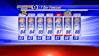
- a mostly-dry forecast through the work week
- what’s up with the tropics?
We hope that you had at least a little time to enjoy the weekend weather -- a great way to start off the month of May. And keep in mind, summer-like heat-and-humidity is just around the corner, so get outdoors while we can still enjoy these relatively comfortable afternoons.
Speaking of humidity, you may have noticed a slight uptick in that department through the day: not uncomfortable, but not “dry” either. After opening May with Baton Rouge dew point temperatures in the low to mid 50°s, we were in the upper 50°s yesterday and those numbers have risen into the 60°s today. That’s just about average for May in the Red Stick and still a far cry from the traditional summer dew points in the 70°s.
So not summer-sticky just yet, but probably enough to get many of you to run the A/C to dry-out the air in your home.
An easterly wave (a surface trough of low pressure tracking from east-to-west) over the north-central Gulf provided sufficient lift today with our low-level Gulf moisture to generate a few showers and even flashes of lightning during the afternoon. The wave will continue to the west through the evening, taking its influence on our local weather out of the picture.
After today, there are no major rain-making features that are expected to impact our local weather. Surface high pressure will remain parked over the eastern U.S. into mid-week with the central Gulf Coast under a south-to-southeast low-level flow. That means continued flux of Gulf moisture into our area.
Daytime highs for metro BR will hover around the mid 80°s for much of the week, possibly climbing into the upper 80°s for many WAFB neighborhoods by week’s end. With the rising dew points thanks to southerly flow, morning lows will display a slow-but-steady rise through the 60°s.
We’re expecting a drier Tuesday compared to today, although a spotty shower or two can’t be ruled out. Even without any significant weather features -- like surface fronts -- to provide lift for our muggy air mass, our daytime heating over the next several days should be enough to spawn a shower here and there each afternoon, especially closer to the coast. Remember, warm-and-moist air is always ready to rise … and our daytime heating in the coming days should be enough to generate spotty to isolated pockets of brief rain each afternoon.
That means daily rain chances at 20% or less through the work week. In fact, as of now, our next significant shot at area rains is not until Sunday.
So ... about the tropical chatter you might have heard over the past few days.
Just about every major forecasting model is showing some sort of low-pressure area developing to the north of the Bahamas later this week. An area of disturbed weather currently near Cuba is expected to track northeast and then turn north by mid-week. There is a chance that this area could take-on tropical characteristics if it were to sit over the very warm Gulf Stream paralleling the U.S. Southeast Coast.
What kind of chance? The National Hurricane Center (NHC) currently says a 30% chance over the next three to five days -- a low chance -- of becoming something tropical. In fact, the NHC is suggesting that if it were to develop, it would probably be a sub-tropical storm.
Sub-tropical storms are hybrid storms, caught somewhere between being non-tropical and fully-tropical systems. Generally, sub-tropical storms tend to be less energetic than tropical storms, but tend extend over a larger area than their tropical cousins. And just like tropical storms, they can produce strong winds, locally heavy rains and storm surge.
Interestingly, while the NHC is currently posting development potential at a low 30% later this week, they already have scheduled an aircraft reconnaissance for Wednesday on the presumption that something of interest will emerge north of the Bahamas by then.
In the meantime, this is certainly not something for WAFB and other local interests to get concerned about. Even if this system were to become a sub-tropical or tropical storm (it would be named ‘Ana’), it offers no threat to the Gulf. Maybe more importantly for us, pre-season storms are not omens of an active season ahead.


No comments:
Post a Comment