
 By Jay Grymes & Steve Caparotta
WAFB Storm Team QuickCast:
- clearing out tonight- record lows possible for Thursday & Friday mornings
- looks mainly-dry through the next 7-10 days
For most of us, today's main rains arrived before the lunch hour. There were two somewhat distinct rainmakers at work across the South: a rather weak cool front which was already east of Baton Rouge by mid/late morning and a mid/upper-level disturbance located to our west and northwest.
The clouds and scattered rains kept the air rather muggy but also held daytime highs in the 70°s through the morning, but the cooler air began arriving by mid-day with Red Stick area temps dropping into the 60°s by the early to mid afternoon.
The cool front generated some local showers and a few t-storms along a north-to-south line in the morning. Titan9 Doppler even suggested that the bigger storms closer to the coast may have generated some small hail earlier in the day. But as we headed into the mid-day and early afternoon, the two main bands of showers and embedded t-storms were east of the Capital City, leaving just a few sprinkles in and around the viewing area for the remainder of the afternoon. At the same time, the upper-air disturbance to our west and northwest tracked towards the northeast, keeping most of its rainmaking potential north of the WAFB viewing area.
Drying Out, Turning Cooler!
We say, "good riddance!" -- our area has had more than enough rain over the past five days. Let's get to the sunshine. And that's exactly what we're going to do; in fact, not only will we get a nice run of fair-and-less-humid days (albeit brief), but we’ll flirt with some record lows for both Thursday and Friday mornings!

Normal daily lows are typically in the mid 60°s for Baton Rouge. (As a reminder, for weather scientists, 'normal' means a 30-year 'smoothed' average, and current normals are based on observations from 1981-2010). However, our forecast for the next two mornings is calling for lows in the upper 40°s to around 50° for just about everyone along and north of the I-12 corridor. For Baton Rouge, anything at or below 50° on Thursday and Friday will establish new record lows.
Thursday will be gorgeous with sunshine and blues skies, highs in the low 70°s for metro BR, and dew point temperatures in the 30°s and 40°s -- May dew points are typically in the 60°s. A modest warm-up begins on Friday under mostly sunny skies as we climb up to around 80° or so for the afternoon.
Warmer, Staying Dry into the Weekend
Although Gulf humidity will slowly creep back into the viewing area through the weekend, both Saturday and Sunday look just fine for some outdoor fun. We're calling for a mostly sunny Saturday with highs in the low 80°s and a fair-to-partly-cloudy Sunday with highs in the mid 80°s -- it’s a "sunscreen weekend" for sure.
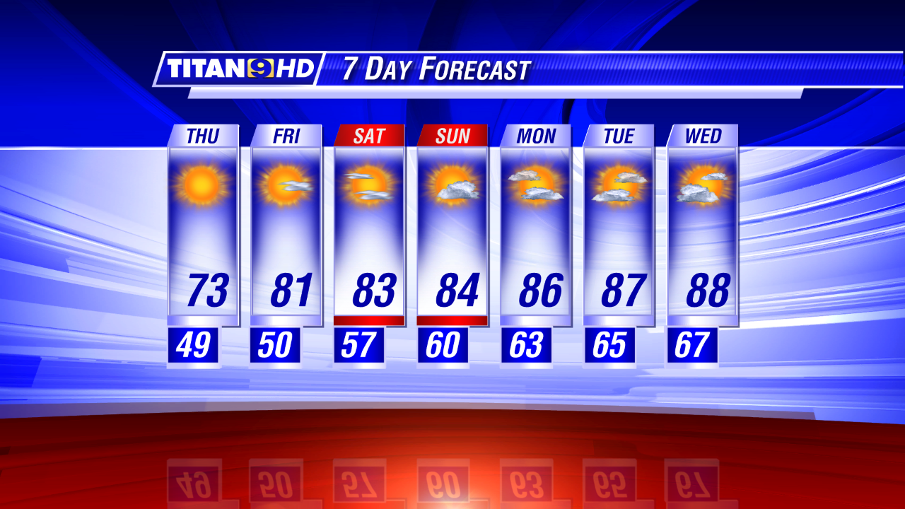
For the time being, our extended outlook stays dry too. In fact, our key extended-range guidance tools suggests that we stay essentially 'rain-free' not jus through this weekend but also right into -- and possibly through -- the following weekend (May 24-25).
No comments:
Post a Comment