Friday, January 30, 2015

Mixed Weather Bag for the Weekend

By Jay Grymes


WAFB First Alert Quickcast:

- closer-to-normal temperatures through the weekend
- rain rolls in for Super Bowl Sunday
- even cooler by early next week

Today surely wasn't a day to complain about by January standards. However, it was quite a change in terms of our afternoon temperatures over the past few days. After a run of days in the 70°s, metro Baton Rouge only made it into the low 60°s, with some of WAFB more northern communities barely reaching 60° this afternoon.


And get used to the cooler days too. Not just cooler either: we're expecting daytime highs in the low to mid 50°s for a number of days next week as winter weather makes a return. 

At the same time, many across the country will be waiting on the shadow-driven prognostication of that famous western Pennsylvania groundhog -- Punxsutawney Phil -- or the winter outlook from literally dozens of local rodent "forecasters." Groundhog Day is Monday, February 2nd.

A quick look back at January temperatures: climatologically, even with our recent run of spring-like days, it's been a cooler-than-normal January -- averaging about 48° for Baton Rouge's Metro Airport (BTR) -- about 3° below the monthly norm. By January historical standards, that's cool but certainly not cold. Looking back at the past 50 Januarys, BTR's January average temperature has been below 45° five times, including just last January!

BTR's 8 January days in the 70°s was just about average for the month (long term average is about 9 days), while the 8 January freezes -- including the bitterly cold low of 20° on the 8th -- was a bit above the long-term average of 6 days. By the way, the 8th was also the "coldest day” of the month for our area, not just because of the 20° low -- BTR temps stayed at or below freezing for more than half the day.

As an FYI, the NWS Climate Prediction Center (CPC) three-month outlook for February-March-April (FMA) indicates about a 70% chance for spring-season temperatures to run "near-normal to below-normal" for the WAFB viewing area. The CPC's rainfall outlook for FMA calls for equal chances for "below-normal," "near-normal" and "above-normal" total rainfall for the spring. (In other words, there are no indicators that are suggesting a seasonal trend in one direction or the other.)

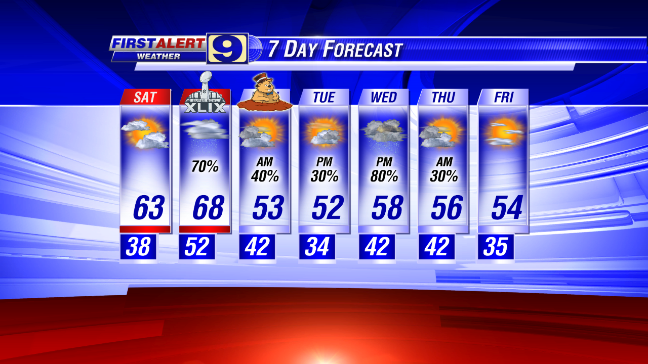
So let’s get back to our local forecast: a 'dry' cold front moved through our region last night. Temperatures didn't fall too far this morning, with lows in the 40°s but it was a much more limited warm-up through the day. North-to-northeast winds kept pushing cool-and-dry continental air into the lower Mississippi Valley. And by early Saturday morning, many of us will have slipped into the mid to upper 30°s. Our Saturday forecast stays dry, although clouds will slowly increase during the latter half of the day. And just like today, it will be another cool afternoon with highs in the low 60°s. 

Storm energy from a system currently impacting the Desert Southwest will make for a wet Super Bowl Sunday here in WAFB land. Some of the computer guidance over the past couple of days was mixed in terms of how the much rain we would get from that system, but we're seeing better agreement now: Sunday will be a rainy day, with a few thunderstorms possible. 

The first rains on Sunday likely arrive well before sunrise, but the main action will be during the middle and latter part of the day. The good news is that there is still no concern for severe weather, even with the current thunderstorm potential in the day’s forecast.

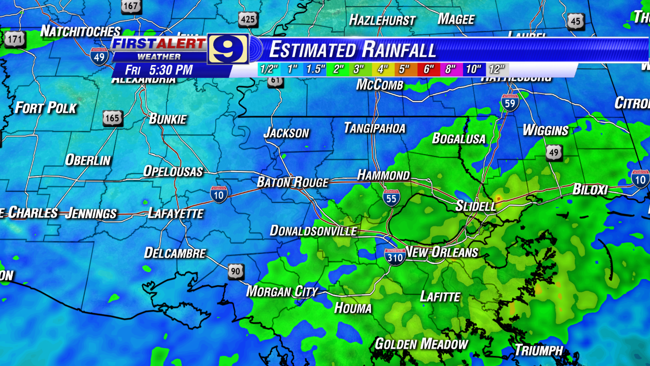
In addition, rain totals still shouldn't be a real problem. Standing water in the usual places? Sure, but rain projections trending on the order of 0.2" to 0.5" with some higher localized totals possible. That's not enough to be a real problem for anyone.

The weather "dries" for Monday but it gets even cooler: expect highs in the low 50°s for Monday and Tuesday for the Red Stick. And, what’s more, the dry spell is short-lived with rain returning to our forecast during the latter half of Tuesday and extending through Wednesday, possibly even into early Thursday. These mid-week rains are likely to be a bit more productive in terms of rain totals. It's too early for high confidence, but we're thinking widespread rains of up to one-inch or more for the mid-week event, resulting in regional totals on the order of 1" to 2" for the full 7-day period. 


That's on the “wet side” of things for February but nor really problematic -- 7-day rain accumulations during early February typically run about 1.0" to 1.5", on average.

So, stay warm! Enjoy the cool Saturday. Stay inside for Sunday: dodge the rain and catch the Super Bowl -- the nation's unofficial football holiday! And keep the jackets and rain gear ready for next week.

Thursday, January 29, 2015

Much Cooler for the Weekend!

By Jay Grymes & Steve Caparotta

 WAFB First Alert Quickcast:

- cooler for the next 7 days or more, but no freezes
- rain returns on Sunday

“Goodbye 70°s!” 

It sure has been fun while it lasted, with today being the third consecutive day in the 70°s under fair skies.  The afternoon temperatures we’ve enjoyed over the last few days have been as much as 8° to 12° or more higher than normal for late January … it’s time to get back closer to something more typical for this time of year.  In fact, by next week, afternoon temperatures could be running as much as 10° below normal!  Such are the big (and frequent) swings in daily temperatures that we often see in the winter months.


And we admit, our temperature forecasts this week have been less than stellar, occasionally missing by more than a handful of degrees with both the morning lows and the afternoon highs.  Today was a great example.  Our forecast last night called for mid to upper 40°s for the morning lows and afternoon highs in the mid 70°s: what we got were lows close to 40° and highs in the upper 70°s for many metro area neighborhoods.  Sometimes, all the computer guidance in the world can’t “out think” and predict what Mother Nature decides to do.

What we do know is that a ‘dry’ cold front will be sliding south through the WAFB viewing area later this evening.  While it brings no rain, the front will deliver a “cooler-but-not-cold” continental air mass that will put an end to our recent run of spring-like days. 

We’ll start Friday off in the 40°s, but highs will struggle to reach 60° in many WAFB communities for Friday afternoon under partly cloudy .  It will be even chillier for Saturday morning, with upper 30°s expected for lows around the Red Stick.  Clouds will be on the increase during the latter half of Saturday, although we have now taken the modest rain chances we had been including for Saturday afternoon off the Saturday forecast board.  Saturday afternoon remains cool like Friday, with highs on Saturday around 60° to the low 60°s.

As we’ve been describing for a few days, a storm system currently over the eastern Pacific will become our Sunday rainmaker.  We’re not talking a lot of rain and no real threat for anything severe.  The latest forecast from the NWS Weather Prediction Center calls for rains on the order of one-quarter to one-half inch for most of the viewing area.

The rains wind down Sunday evening into early Monday, but behind Sunday’s system comes another cool, continental surge, likely delivering highs only in the low to mid 50°s for Monday and Tuesday.  Temperatures will rebound into Wednesday, but that comes with another round of rains.


Bottom line: get ready for a return of South Louisiana winter for the next 7 to 10 days or more.

Wednesday, January 28, 2015

One More Spring-like Day on Thursday

By Jay Grymes & Steve Caparotta


WAFB First Alert Quickcast:

- another spring-like day for Thursday
- cooler, stays dry for Friday & Saturday
- rain returns to the WAFB area on Sunday

Another beauty of a day today under blue skies, and many WAFB neighborhoods managed to climb back into the 70°s for the second straight day. What’s more, the spring-like afternoon weather continues into Thursday.

Skies will stay clear into the night with a few clouds moving in before sunrise. We’ll call it partly cloudy for Thursday’s start with maybe a patch or two of light fog and mild wake-up temperatures in the upper 40°s for metro Baton Rouge. Skies will stay partly cloudy through the day, but it gets a little warmer than today -- plan for highs in the mid 70°s for the Red Stick.

A ‘dry’ cold front slides through the region during the latter half of Thursday, delivering a shot of cooler air to all of us. Although Friday starts out in the mid 40°s across the metro area, the afternoon will be quite a bit cooler with highs expected to top-out in the low 60°s -- about normal for this time of year.


Headed into the weekend, clouds will be on the increase through Saturday, with a morning start in the upper 30°s to low 40°s and highs again in the low 60°s for metro BR. We’ll call it mostly cloudy as we head into Saturday afternoon and evening. While we could see a spotty sprinkle or two during the latter half of the day, most stay dry through Saturday evening into early Sunday.

The big change arrives by mid-day on Super Bowl Sunday. A storm system currently located in the eastern Pacific (to the west of Mexico) will serve as the focus for Sunday rains as it tracks to the northeast-then-eastward over the coming days. We’re not expecting a really stormy event: no concern at this time for severe storms although a thunderstorm or two can’t be ruled out. And for now, rain totals look like they will be rather modest, with most neighborhoods coming in at well under one inch for the day. (We’ll keep an eye on how the models adjust these numbers over the next few days.)

It should get much cooler for Monday and Tuesday, with highs only in the 50°s, and then our guidance shows the next rainmaker arriving sometime late Tuesday into Wednesday.


The winter storm is finally coming to an end for the U.S. Northeast. We’ve talked about it for a couple of days now: while Philadelphia, New York City and most of the mid-Atlantic didn’t get the huge snow totals that had been anticipated, eastern New England was walloped. Preliminary reports suggest a band of 30” to 36” snows extending from extreme southern Maine southward through southern New Hampshire, eastern Massachusetts, and into northern Rhode Island and parts of Connecticut. Even if those aren’t record numbers, the impacts have been serious, even deadly in a few cases. And that doesn’t include the tens of thousands that lost power in the extreme cold nor the millions of dollars in damage from the coastal storm surge produced by this mid-winter Nor’easter.


Tuesday, January 27, 2015

Not Quite as Warm on Wednesday

By Jay Grymes & Steve Caparotta

WAFB First Alert Quickcast:

- no rain through the work week
- temperatures on the mild side through the weekend

The monster snow storm in the U.S. Northeast continues to churn away.  While the projected “record-breaking” impacts failed to develop in places like the Nation’s Capital, Philly, and the Big Apple, there’s no denying that this was a major winter storm for eastern New England, where heavy snows -- upwards of 24” to 30”+ in some spots -- combined with winds gusting into the 50s and higher to produce prolonged blizzard conditions and “white outs.”  Add to that the coastal impacts of destructive “tropical-like” storm surge and tens of thousands without power in the bitter cold.  Even down here, we’ll ‘feel’ the effects as it will likely be at least a few days before East Coast air travel returns to something near-normal.


For us, the past few days have not been bad at all!  Okay, I admit that today our temperature forecast for today was a bit of a bust: lows dipped a few degrees below our Monday evening forecast with afternoon highs getting well above our “upper 60°s” projections for this afternoon as highs climbed into the 70°s for everyone in the viewing area.  We under-forecasted the highs largely due to today’s lack of steady NW winds: less mixing in the low levels allowed today’s sunshine to warm things up more rapidly.

A weak, barely-perceptible backdoor front is moving through the Lower Mississippi Valley this evening.  It won’t have much effect on our overnight and early morning temperatures, but by mid-day tomorrow it delivers just enough cooler air from the northeast to keep us out of the 70°s.  And even with this front moving by, don’t look for any clouds tonight or tomorrow.  Yes, Tuesday will be a little cooler than today, but a nice January day nonetheless.

It’s back to the 70°s under partly cloudy skies for Thursday, after a morning start in the mid 40°s for Baton Rouge with a little patchy morning fog.  Then here comes another front, but this one too looks to be rain-free.  What it will do is deliver a weak surge of cooler air which keeps highs in the 60°s for Friday and into Saturday too.

So about that weekend: Saturday stays mainly-dry, although we’ll add slight rains chances -- at 20% or less -- into the afternoon and evening forecast.  A storm system currently sitting over the eastern Pacific will turn to the east, reaching the Southern Plains over the weekend and getting a boost from a ‘parent’ cut-off upper low behind it.

We’re more confident about our forecast for a wet Sunday right now, looking at upwards of 0.5” to 1.0” of rain as the system slides through.  The good news, at least for now, is that there does not appear to be a severe-weather threat with Sunday’s weather.


Sunday’s system should be out of the way by early Monday, but it will leave us with cooler days for Monday and Tuesday.  For now, we’ll go with a few lingering light showers early Monday morning with a sun/cloud mix for the afternoon.  For Tuesday and into the mid-week, the GFS model is suggesting that energy associated with that same cut-off upper low that was left behind over the weekend finally drifts east to create an unsettled weather pattern.  We’ll keep a watch on to see how this scenario progresses.

Monday, January 26, 2015

Another Beauty on Tuesday!

By Jay Grymes & Steve Caparotta

WAFB First Alert Quickcast:

- stays dry through Friday
- a couple of ‘dry’ fronts pass by over the next few days

If you haven’t heard about it, we’ve got an out-of-this-world visitor making a fly-by today and tomorrow.  Labeled ‘2004 BL86,’ this is an asteroid about one-third of a mile across - - pretty big by Earth standards for close fly-bys.  So just how close?  Oh, about 745,000 miles out -- about three times farther away than the Moon!  So it offers no threat whatsoever, but what makes it interesting is that it is the closest (significant) space visitor in decades and will be the closest until 2027.


So can you see it?  Well, maybe.  Certainly not with the naked eye and probably not with a standard pair of binoculars.  But if you have a decent telescope, look in the sky tonight around 10pm just a little to the right of the bright object, the planet Jupiter.  For those that know their constellations, ‘BL86’ will be tracking through the heart of Cancer between roughly 6pm tonight and 6am tomorrow.

As for the rest of us … here’s the forecast: Tuesday’s sunrise will be a little cooler than earlier today.  Look for a morning start in the low 40°s for metro Baton Rouge under clear skies, with upper 30°s closer to the LA/MS state line.  Sunshine rules through the day on Tuesday, and that should help propel highs into the upper 60°s. 

A ‘backdoor’ cold front -- a dry front approaching from the northeast -- pushes through the Lower Mississippi Valley Tuesday evening into Wednesday morning.  It doesn’t deliver a true winter chill, but it will knock temperatures back a couple of degrees for Wednesday, even with mainly-sunny skies.

By Thursday afternoon, many WAFB communities will rebound into the 70°s, with fair to partly-cloudy for the day.  At the same time, here comes another ‘dry’ front - - this time along a more ‘traditional’ NW-to-SE trajectory.  That front gets through our viewing area late Thursday into early Friday and cools us off again, with highs on Friday struggling to reach 60° for some of our neighborhoods.


A broad mid/upper-level disturbance from the west begins to approach the area as we head into the weekend.  Saturday starts off dry and remains dry for most: set afternoon and evening rain chances at about 20% for the WAFB area.  But by Sunday, we’ve got “rain likely” posted, at least for now.  Admittedly, there is still some uncertainty about just how wet it gets on Sunday, and our current estimate is ranging a little on the high side of some of the long-range guidance.  But we’ll be able to tweak that as the week progresses.

Friday, January 23, 2015

Big Improvements for the Weekend!

By Jay Grymes & Steve Caparotta


WAFB First Alert Quickcast:

- another wave of mainly-light showers arrives this evening
- becoming sunny on Saturday, mostly sunny for Sunday
- dry for all of next week

Our run of rains last night and this morning delivered widespread rains of 1.5” to 3.5” for the WAFB area: not enough to be a real concern for our local rivers and bayous but enough to generate standing water in the usual places and make for a not-so-happy morning commute.


While the rains came to an end for most of us by or even before the early afternoon, the dense overcast deck, the northwesterly winds, and the lingering dampness through the day maintained a real winter ‘feel’ to the air. For most of us, it was not what the doctor ordered.

What’s more: we’re not quite done with the umbrellas just yet.

Another wave of mainly-light showers to our west is headed our way. We think that most of it -- possibly all of it -- remains west of metro BR through the evening commute but it does get in here later in the evening. The good news is that it shouldn’t generate much in the way of rain totals and doesn’t last long either. We think that most or all of it will have moved east of the area by midnight or so.

The clouds will begin thinning after midnight, with some clouds likely still lingering around sunrise. We’re calling for Saturday sunrise temperatures in the mid 30°s with skies continuing to clear. Look for a Saturday afternoon high in the upper 50°s for the Red Stick: quite an improvement over the past couple of days.

Sunday is a winner too: we’ll start off with sunrise temps in the mid to upper 30°s for most of us with mostly sunny skies and afternoon highs in the low 60°s.

For next week, we keep things dry right through the work week, with mainly sunny skies for most days. Temperatures throughout the week will be running near-normal to slightly above-normal -- lows in the upper 30°s to low 40°s for most days with highs each day in the 60°s.


So enjoy the sunny, warmer weekend!

Thursday, January 22, 2015

Rains Diminish, Staying Gloomy on Friday

By Jay Grymes & Steve Caparotta

WAFB First Alert Quickcast:

- rains continue into the night
- rains ending on Friday, stays cloudy & cool
- sunshine returns for the weekend

The first of today’s rains arrived a little later in the day than we expected, but they still got here in plenty of time to add to the mess of this evening’s commute home.  Thankfully there haven’t been any extra-heavy downpours as yet and very few rumbles of thunder.  However, as the afternoon and evening progress, be ready for occasions where the rains do fall a bit heavier.

There is no severe weather threat ... and no concern for significant flooding, although we’ll likely see standing water in the usual spots later this evening and tonight.

Everyone gets rain tonight, with the heaviest rains exiting the area well before sun-up on Friday; in fact, for many of you, the most significant rains will have passed to the east not long after midnight.  But there will still be additional, mainly-light rains to come into Friday.  We’re keeping scattered showers in the forecast for Friday morning, so it’s looking like a wet morning bus ride and morning commute.  Morning temperatures will be in the 40°s, so let’s call it “chilly & wet” to paint the complete morning picture.


We’ve got showers winding down through the morning and into mid-day, with a mainly-dry forecast for Friday afternoon.  Yes, a lingering sprinkle or two during the afternoon is still possible, but nothing in terms of real accumulations.  Regardless, the clouds will remain through the day: add in a northerly to northwesterly wind and you’ll have a cool, if not downright chilly, Friday afternoon on the way.  We’ve mentioned it a couple of times in our forecasts: many WAFB neighborhoods will be lucky to reach 50° on Friday afternoon.

The clouds will linger into the early hours on Saturday, then should all clear out Saturday morning.  We’ve got a forecasted low in the mid 30°s for the Capital City on Saturday morning with sunshine for most of the day.  Saturday highs should climb into the mid to upper 50°s.  Skies stay clear through Sunday, with a morning low in the mid to upper 30°s and a high in the low 60°s.


Our forecast for next week is a good one.  Not only does it stay dry through most -- in fact, probably all -- of the work week, but there should be plenty of sunshine most days too.  It won’t get as warm as the “spring-like” days in the 70°s that we had earlier this week, but afternoons should return to the 60°s each day with morning lows in the upper 30°s and 40°s.  All-in-all, temperatures will be near-normal to slightly above-normal through the week under fair skies.  Sounds good for January!

Wednesday, January 21, 2015

Grab the Umbrellas & Jackets!

By Jay Grymes & Steve Caparotta


WAFB First Alert Quickcast:

- rain and cooler too for Thursday & Friday
- sunshine is back for the weekend

Today was yet another “spring-like” day in this run of January beauties, and there were fewer clouds today than we expected too.

But all good things must end, and this run of weather ends tonight.

Clouds will be returning later this evening and overnight with cloudy skies expected for Thursday morning. We could even see a couple of showers for the early morning commute as we begin the day in the upper 40°s for the Capital City. But as we move towards mid-day and the afternoon, rain chances climb quickly, with just about everyone getting rain for the afternoon and evening.


The bulk of the rain over the next 48 hours comes on Thursday afternoon and into the evening, but we’ll still have some areas of light rain and showers extending into Friday. Rains should be about done for everyone by, if not before, Friday afternoon but clouds will linger into Friday night.

What’s more, after this recent run of days in the upper 60°s to low 70°s, afternoon temperatures take a big nosedive, topping out in the low to mid 50°s for many WAFB neighborhoods on Thursday. Many won’t even reach the 50°s on Friday after a Friday morning start in the low 40°s.

The rain over the next two days will be courtesy of two features: a surface low tracking west-to-east across the northern Gulf working with an upper-level low and associated upper-trough moving from west-to-east to our north. The Gulf low will help supply the moisture with the upper-low and trough provide added lift and pull the Gulf moisture inland.

We’re looking for 1” to 2” of rain for most WAFB communities over the two days, with the vast majority of that falling on Thursday. There is little or no threat for severe weather; in fact, any thunderstorms that form will likely be limited to the coast and over the Gulf waters.


We’ll sweep the wet mess out, leaving us with mainly sunny skies for the weekend but it stays cool as the upper trough pulls Canadian air down into the lower Mississippi Valley. Saturday morning lows will get down into the low to mid 30°s -- a light freeze will be possible for areas north of the Capital City. It does get a little warmer under the sunshine for Saturday afternoon, with most WAFB neighborhoods in the 50°s. For Sunday, it’s the mid 30°s for the sunrise start and highs around 60° or so under sunny skies.


Our extended forecast beyond the weekend remains mainly sunny through at least mid-week.

Monday, January 19, 2015

Staying Mild Through Wednesday

By Jay Grymes & Steve Caparotta

WAFB First Alert Quickcast:

- more clouds, mild for Tuesday and Wednesday
- rain returns for Thursday into Friday

Admittedly, our morning temperatures dropped several degrees lower than expected, with freezes reported across most of the Baton Rouge metro area to start the day.  But the air warmed quickly during the morning with most neighborhoods in the 40°s before 9:00am and many in the mid 60°s by lunchtime. 


No doubt about it: a beautiful Monday whether you were attending dedications and remembrance ceremonies, doing a little community service, or just enjoying a day off.  In fact, even if you had to work today (like us), the sunshine, blue skies and mild afternoon temperatures should have put a smile on your face.

It looks like we are done with freezes for a while, but the fine weather over the past few days certainly can’t last forever either.  We’ll go with morning lows in the mid 40°s for metro Baton Rouge on Tuesday with a Tuesday high near 70° under a sun/cloud mix to mostly cloudy skies.  Wednesday begins in the upper 40°s to near 50° for the Red Stick with highs in the upper 60°s.  For Wednesday, the morning starts under mostly-cloudy to cloudy skies, easing to a sun/cloud mix for the afternoon.  A weak (and dry) cool front slides through the lower Mississippi Valley late Tuesday night into early Wednesday; the modestly-cooler air behind Wednesday’s front won’t have much of any effect on Wednesday morning’s low given the cloud cover, but it should keep Wednesday afternoon highs a few degrees cooler.

We’ve been talking for a few days now about the developing weather coming on Thursday and Friday.  A mid/upper-level disturbance will become better organized as it exits the Southern Rockies and heads east across the Southern Plains.  As the same time, Wednesday’s front will stall over the Gulf.  An area of surface low pressure will form along the stalled front and track eastward over the open Gulf while the upper-air disturbance tracks east across the Gulf States.  The two features will be enough to keep us under the clouds for just about all of Thursday and Friday … and generate rains from Thursday into the first half of Friday. 

It will be a cold, “overrunning” rain for both days -- highs for Thursday and Friday will struggle to make the 50°s, especially for some of WAFB’s more northern neighborhoods. 

Rain totals will remain modest, so there’s no need to be concerned about any flood threats.  Very-early rain estimates for the viewing area from the NWS Weather Prediction Center suggest a north-to-south increasing gradient for the two-day totals, ranging from under 0.5” near and north of the LA/MS border up to 1.0” or more closer to the coast.  (We’ll keep an eye on these rain projections over the coming days.)  While we won’t rule out a rumble or two of thunder, especially along the coast, severe weather will not be a concern on Thursday or Friday either.

The rains should be ending from west-to-east during daytime hours on Friday, although it is still a little too soon to say when.  We’re thinking that the bulk of the rains should be off to the east before noon, although a few lingering showers could hang into the mid to late afternoon.  Regardless, skies should begin clearing well before Saturday’s sunrise. 


The upcoming weekend will be “cool-ish,” with morning starts in the 30°s and afternoon highs in the upper 50°s for the Capital City.  We’ll keep an eye on the Saturday morning outlook as some WAFB communities might flirt with a light wake-up freeze, but we’re expecting mainly-sunny skies on Saturday and fair to partly-cloudy skies for Sunday.  

Sunday, January 18, 2015

- Jay Grymes / WAFB Chief Meteorologist
 
- fair skies for the next couple of days
- rain returns later in the work week
 
It wasn't nearly as chilly a start today compared to recent mornings, even with the light NW winds.  And our mainly sunny skies through the day took most WAFB neighborhoods into the upper 60°s with some folks briefly reaching the 70°s during the afternoon.  A nearly-perfect Sunday for January across the region ... and the marathoners loved it too.
 
A weak, dry cold front slipped through the state early this morning, doing little to affect today’s weather, but it does introduce a reinforcing dose of slightly-cooler and less-humid continental air from the north and northwest into the lower Mississippi Valley.  So it’s mainly clear skies for the overnight and into Monday morning, with Monday sunrise temperatures down in the mid to upper 30°s for metro Baton Rouge.
 
 
Monday -- Martin Luther King Day -- will be another January beauty, and back into the upper 60°s for most of us under mainly-sunny skies.  A slow warming trend continues into the week, with a morning low in the low to mid 40°s for the Capital City on Tuesday with afternoon highs in the upper 60°s to around 70° under fair to partly-cloudy skies.  Here comes another front on Wednesday morning, but it arrives “dry” just as Sunday morning’s front did.  Plan on partly-to-mostly cloudy skies for early Wednesday, with the cloud cover easing back just a tad by the afternoon.  Wednesday starts out in the mid to upper 40°s, with the cooler air mass behind the morning frontal passage keeping the afternoon highs in the low to mid 60°s for most of us.
 
Of course, the great weather and sunshine can’t last forever.  We’re bringing rain back into the area on Thursday.  Thursday’s rain will be mainly a cold, “overrunning” rain resulting from a combination of alingering area of low pressure in the central Gulf associated with Wednesday’s front plus a little extra lift provided by an east-bound upper-level system tracking out of the Desert Southwest.  Highs may struggle to reach the 50°s for some WAFB neighborhoods on Thursday and Friday thanks to the cold rain and cloud cover.
 
 
But for most of us, the rains on Thursday and Friday aren’t terrible news.  The wet system exits the region on Friday, leaving us with a cool but mostly-fair weather for NEXT weekend.

Friday, January 16, 2015

Good Looking Weekend Ahead!

By Jay Grymes & Steve Caparotta


WAFB First Alert Quickcast:

- fair skies through the weekend and into next week
- 60°s return for the next several days

“Welcome back, Mr. Sunshine! Adios to the clouds and cold!”

As we expected, well over half of the WAFB viewing area dipped to freezing or below earlier this morning under those mainly-clear skies. Those clear skies also meant plenty of sunshine through the day, although the light northerly flow slowed the daytime warm-up. Still, most WAFB neighborhoods reached the mid to upper 50°s with a few flirting with 60° -- a big improvement over the past three overcast days when highs topped-out in the 40°s!


We’ll stay with mainly sunny afternoons throughout the weekend too, with the good stuff extending right through Monday, Martin Luther King Day.

Yesterday we talked about another light freeze for Saturday morning, but we’ll back off of that just a little for the Red Stick. Now it looks like a Saturday morning start that will still get well down in the 30°s, but most in and near the Capital City may dodge 32°. However, the freeze line won’t be all that far to the north Baton Rouge: communities there should expect a light freeze again for Saturday morning, but only for a couple of hours at most.

Then the welcomed but slow warm-up that started this afternoon continues as we climb into the 60°s for Saturday afternoon … okay, some WAFB communities north of the LA/MS border may only top-out in the upper 50°s. But hey, after the previous few days, that will be just fine! Sunday morning starts out chilly too -- ranging from the mid 30°s north to the low 40°s south -- but fair skies and sunshine should mean low to mid 60°s for just about everyone into Sunday afternoon.

If you’ve been watching our weathercasts over the past few days, we’ve been noting a cold front that will swing through the lower Mississippi Valley on Sunday morning. But it will be a “dry” front -- in fact, it brings a few clouds at most and really doesn’t provide much of a cold-air surge either. Many of you won’t even notice it.

Monday, MLK Day? Looking good too as we get into the mid to upper 60°s for afternoon highs.

Our forecast stays dry through mid-week, although we anticipate the next front to arrive on Wednesday. Based on our guidance, Wednesday’s front arrives “mainly dry,” but stalls along the coast. It lingers there for a day or two, picking up Gulf moisture and getting a little upper-air support (lift): that means rain returns for Thursday into early Friday. But the way it looks for now, the frontal complex heads east on Friday, taking the rains with it.


If that scenario pans out, it should leave us with somewhat cooler but dry weather for NEXT Saturday and Sunday.

In the meantime, enjoy THIS weekend ... and enjoy the sunshine!

Thursday, January 15, 2015

Finally Some Sunshine on the Way!


WAFB First Alert Quickcast:
- rains ending, clouds slowly clearing
- light freeze for Friday & Saturday wake-ups for many
- milder into the weekend
 
Another truly nasty day: cold and wet with a thick overcast blocking the sun.  However, there is some (sun)light at the end of this cloud tunnel.  In fact, some of WAFB’s more western neighborhoods may see some sun streaks through the thinning clouds before sunset, although many WAFB communities may have to wait until tomorrow for the warming rays. 
 
We’re just about done with the rains as of the mid-afternoon, although some light showers continue to pop-up, especially closer to the coast.  And after this long run of a persistent overcast, the clouds will steadily clear-out through the evening and overnight.
 
We mentioned yesterday that while the clouds have kept the daytime temperatures rather chilly, those same clouds were keeping the overnight temperatures a little higher than what we would have experienced under fair night skies: the clouds were insulating us.  Well, that blanketing layer will disappear this evening and overnight while we maintain a light northerly wind. 
 
That combination will mean a light freeze for many WAFB neighborhoods, especially those north of the I-10/12 corridor.  We’re calling for a metro Baton Rouge morning low on Friday right at 32°.
 
Clear skies and sunshine on Friday morning should mean a nice warm-up, with temperatures rising into the mid to upper 50°s by Friday afternoon – boy, will that feel good!
 
It should be a nice January weekend - - and well-deserved too after the recent run of cold weather.  Plan for an equally cold start on Saturday, with sunrise temperatures for many of us in the low to mid 30°s, but fair skies during the day gets most of us into the low 60°s for Saturday afternoon.  And the slow warm-up continues into Sunday, with fair skies and a morning start around 40° for Baton Rouge with afternoon highs in the low to mid 60°s.
 
A “dry” cold front slides through the lower Mississippi Valley on Sunday.  Monday morning’s start will be in the mid to upper 30°s but we’ve got fair weather on the forecast board for Monday with highs in the low to mid 60°s.  It should be fair to partly cloudy skies for Tuesday with highs in the upper 60°s.  Although we’ll add-in a slight rain chance for Wednesday afternoon and evening, right now it looks like just about everyone stays dry until next Thursday.

Wednesday, January 14, 2015

Damp, Staying Chilly on Thursday

By Jay Grymes & Steve Caparotta

WAFB First Alert Quickcast:

- thick cloud deck persists
- rains move in tonight into Thursday morning
- a little warmer over the weekend

The clouds have taken hold and their firm grip continues through the night and well into Thursday.  In fact, it now looks like the rains we’ve been talking about for several days will hang around later into the day on Thursday than what we previously thought.  If you remember, yesterday we had the rains around mid-day or so with skies clearing through the mid to late afternoon.  The latest guidance now keeps the rains in the area past noon, then slowly tapering off into the late afternoon. 

So it will be a wet morning drive with the last lingering showers still in the area for the evening commute.  The clouds also hang around longer too: with the slow clearing not beginning until the early evening.

All that means a couple of things in terms of temperatures.  Like yesterday and today, the heavy deck of clouds kept afternoon temperatures for many WAFB neighborhoods in the upper 30°s to 40°s -- nearly 20° below seasonal norms.  But like last night and early this morning, the clouds will also keep overnight and early morning lows on Thursday a little warmer than we would expect under fair skies, given the steady low-level northerly winds. 

We’ll call for a Thursday morning low in the upper 30°s for the Baton Rouge metro area.  So it’s a cold start to the day and remember, you’ll want the umbrella as you step out the door tomorrow morning.  The rains will begin overnight with the first isolated showers possibly arriving in the WAFB viewing area before midnight.  The rain coverage expands through the pre-dawn hours, making for that wet morning drive and bus ride for the youngsters. Yesterday we were thinking about a 50% to maybe a 60% rain chance for the Red Stick: now we’re upping that to 70% or more.


Thursday’s “overrunning” rains under gray skies will be fueled by an area of low pressure over the northern Gulf, which gets an upper-air “assist” from a disturbance passing by to our north.  There is no threat for severe weather: any active thunderstorms should remain over the Gulf as the surface low moves to the east.  So these won’t be heavy rains … just a “cold” rain.  We’re thinking rain totals by Thursday evening for most of us will come in somewhere between 0.1” to 0.3” with totals approaching a half-inch along the coast.

Once the winter Gulf low and the upper-air energy shift farther to the east, we’ll see a welcomed clearing of our skies.  But the northerly surface flow remains in play throughout Thursday and into Friday.  We’ll lose the “insulating/blanketing” effect of the clouds for our overnight temperatures and that means a colder start for Friday morning under fair skies.  The Capital City will flirt with a light morning freeze to start Friday and our friends along the LA/MS border could see lows in the upper 20°s.

But with mainly clear skies through the day, the sunshine should get most WAFB neighborhoods into the mid to upper 50°s by Friday afternoon.  It’ll be another cold start for Saturday, with sunrise temperatures for many of us in the low to mid 30°s, but fair to partly-cloudy skies during the day gets us in the low 60°s for Saturday afternoon -- something closer to mid-January normal highs.

The forecast for Sunday is a good one too, with a morning start in the 40°s and afternoon highs in the 60°s for just about everyone.  All in all, a fine looking January weekend, and well-deserved after such a cloud, chilly and all-around disagreeable work week.


Our current extended forecast now remains mild and mostly-dry through mid-week.​

Tuesday, January 13, 2015

Staying Under the Clouds!

By Jay Grymes & Steve Caparotta

WAFB First Alert Quickcast:
- clouds remain, colder tonight
- a little rain returns for late Wednesday into early Thursday
- modest warming over the weekend

A tendency towards clouds will persist into the first half of Thursday, with a chance of mainly-light rain very late Wednesday into early Thursday. In addition, temperatures will remain below-average through Saturday morning before moderating just in time for some weekend fun.

Northerly flow at low levels will keep things cool for the next several days. In fact, were it not for the clouds, metro Baton Rouge would probably get a brief, light freeze for tomorrow’s wake-up. However, Pacific moisture at the mid/upper-levels is being chilled from below by the surface cold air from the north, and that should keep a decent cloud deck in place over our region through tonight and Wednesday. Fortunately, although the surface air is chilly and dry, the cloud deck above should offer sufficient “insulation” to keep most of us above-freezing tonight and into Wednesday morning. The possible exceptions would be WAFB communities near and north of the LA/MS border: they might flirt with a brief wake-up freeze.

We could see some peaks of sunshine on Wednesday, but we’re thinking a mostly-cloudy to cloudy day as the rule with highs in the low 50°s for metro BR. Heading into late Wednesday, we’ll introduce modest rain chances that will linger into Thursday morning, For now, let’s call it a 50% chance from late Wednesday evening into late Thursday morning for the Capital City -- running a little lower for our more northern viewers and running 60% or better closer to the coast. 


Low pressure over the Gulf will be the rainmaker, but with the main storm energy remains well to our south and out over the open waters: that means generally-light “overrunning” rains for most or all of us. While some may hear a rumble or two along the coast, we don’t expect any active weather and most rain accumulations should be under a quarter-inch. In fact, some along and north of the LA/MS state line may see little if any measurable rain.

Any rain that does fall should be over before the lunch hour on Thursday, with the clouds clearing through the afternoon. Thursday morning’s clouds and scattered rains should keep Red Stick area lows in the upper 30°s to low 40°s. And while skies should be clearing through the afternoon, highs on Thursday will top-out in the low 50°s for Baton Rouge.

We’re currently calling for a low of 33° for Metro AP on Friday morning, but with the chilly northerly flow still in place and generally clear skies for Friday morning, that has the look of a light, brief wake-up freeze -- at least for those living north and east of metro BR. Sunshine through the day should take Friday highs into the upper 50°s -- possibly around 60° for some -- on Friday afternoon. And while many of us will drop back down into the mid 30°s for Saturday’s sunrise, just about everyone sees highs climb into the 60°s under fair to partly-cloudy skies for Saturday afternoon.


And for now, Sunday looks pretty good too: a sun/cloud mix through the day with morning lows in the 40°s and afternoon highs in the mid 60°s -- a welcomed dry and mild January weekend!

Monday, January 12, 2015

Clouds Linger, Cooler on Tuesday

By Jay Grymes & Steve Caparotta

WAFB First Alert Quickcast:
- stays dry, but clouds linger through Tuesday into Wednesday
- cooler days, with highs in the 50°s through Friday

We started the day rather mild, with morning temperatures in the mid and upper 50°s and a few passing showers. The big weather story this morning with the widespread dense fog, which persisted into the late morning for some locations. 

The wet and “almost warm” feel for the past couple of days exits the region this evening and overnight -- a cold front has pushed through the WAFB area today and continues its march to the east. The front wasn’t much of a rainmaker, with spotty light showers and patchy sprinkles at best, but you may have noted the “FROPA” (frontal passage in meteorology shorthand) by the day’s wind shifts. Through the morning and early afternoon, the winds veered (clockwise shift) from a muggy southwesterly flow off the Gulf to a “drier” (less humid) flow from the northwest (behind the front).

So we say “Goodbye!” to the rains and to the 60°s, although it looks like the clouds will hang around for another day or more. In fact, we’re calling for a return of isolated showers late Wednesday into early Thursday before we get a complete “clear out.”

Look for Tuesday morning lows in the mid 40°s for the Red Stick with Tuesday afternoon highs in the low 50°s. By Wednesday morning, the drier, continental air will take lows down into the mid 30°s for metro Baton Rouge, with WAFB communities near and north of the LA/MS state line flirting with a light, brief freeze. We’re calling for highs in the low 50°s for both Wednesday and Thursday.


A reinforcing surge of drier air on Thursday should clear skies by the evening and take the Capital City to a light wake-up freeze on Friday. But the cold air doesn’t stay long: it’ll be mid to upper 50°s under sunshine for Friday, then mid 30°s for Saturday morning. And by Saturday afternoon, Baton Rouge should be back in the 60°s.

Thursday, January 8, 2015

Another Freeze, Wintry Mix on Friday?

By Jay Grymes & Steve Caparotta

WAFB First Alert Quickcast:
- freezes return tonight and Saturday morning
- wintry mix possible for Friday?
- slowly getting warmer through the weekend
- rains are back for Sunday and next week

The good news: the lowest of the temperature readings are gone, at least for some time to come. Baton Rouge dropped to 20° -- tying the record for this date -- and McComb set a new record for today with a bitterly cold low of 15°! Other sites across the region approached, tied or set record lows too. And the cold lingered well into the day: Metro Airport was still at freezing as late as 12:30pm!


Just about everyone topped-out in the 30°s for highs today -- way too cold for South Louisiana. 

The not-so-good news: with today’s chilly high temperatures, it won’t take long this evening before most of us are back below freezing. For Baton Rouge, while we won’t get nearly as cold tonight into Friday morning as we were earlier today, freeze durations around the metro areas and points north will still run as much as 10 to 14 hours or more. We’re expecting lows tonight in the upper 20°s for the Capital City.

The developing story -- and scuttlebutt at the water coolers -- is with regard to the potential for wintry precipitation on Friday. We’re setting precipitation percentages at 30%, possibly 40%, for the day as a whole, but those chances are lower during the early morning. If we do get some early morning precipitation, it won’t amount to much, although it could be in the form of a little sleet, maybe even a few flakes or ice pellets, especially north and west of metro BR. Surfaces in the morning will also support freezing rain (falls as liquid then freezes on contact), but again, we think that any areal coverage in the early morning will be very limited and what does fall will generate very little, if any, accumulations. If we do get something falling on Friday, the best chance will be more towards the middle of the day. 


In either case, we are not anticipating a real problem for the morning commute. However, if you encounter moisture on elevated surface and bridges, drive with extra care. There isn’t likely to be any kind of problem on well-traveled roads and bridges, but be cautious on rural bridges -- again, mainly to the north and west of metro BR.

We’ve got another freeze on the way for Saturday morning -- with lows again down in the 20°s for the Red Stick, but it looks like that will be the last freeze for a while across metro BR. Saturday should be a partly cloudy day, although it stays rather cool with highs only reaching the mid to upper 40°s. Saturday begins a slow warming trend, with metro area lows in the mid 30°s for Sunday morning and highs on Sunday afternoon in the mid 50°s. 


The weekend warming will not be the only change to our weather: we’ll trade in our recent run of dry weather for a wet spell. We’re calling for scattered-to-likely rains each day from Sunday through Wednesday. Fortunately, these aren’t likely to be heavy-rain days -- the NWS Weather Prediction Center is calling rain totals of roughly 1.0” to 1.5” for our area over the next 5 to 7 days.