Monday, March 31, 2014

Warm Start to April!

By Jay Grymes & Steve Caparotta

WAFB Storm Team QuickCast:

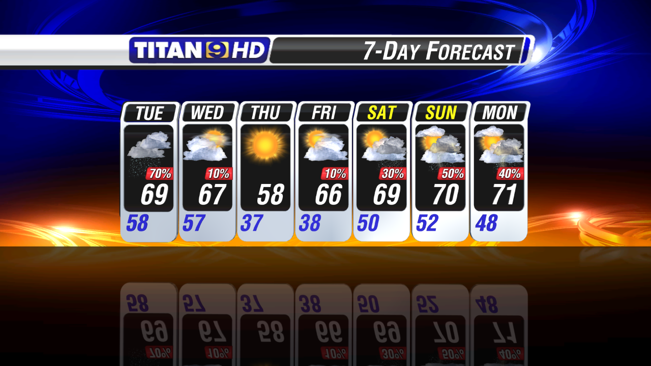
- becoming partly cloudy with patchy wake-up fog for Tuesday
- mainly dry through Wednesday, 30% rain chance by Thursday
- looks ‘wet’ for Friday and a good portion of the weekend

March Recap

It was another cooler-than-normal month for Baton Rouge’s Metro Airport, the fifth consecutive month with an average monthly temperature below the norm.  And for most of the viewing area, rains were below normal for the month also, although some locations -- like portions of SW Mississippi -- saw more water than they wanted toward month’s end.  For most of us, March is “going out like a lamb!” ... and we doubt that anyone’s complaining!  Areawide, the last day of March was a near-perfect spring day.
As for our forecast for the first days of April, it comes as a mixed bag.
Some low clouds will sneak into the region by Tuesday morning accompanied by a little morning fog as metro Baton Rouge begins the day in the mid 50°s.  We’ll go to partly cloudy skies for Tuesday with highs in the 80°s for many WAFB neighborhoods.  The south-to-southeast winds will transport Gulf warmth and moisture into the region with the added humidity giving the air a slightly warmer ‘feel’ compared to today’s drier air that was in place.  By Wednesday and Thursday, the Gulf influence will translate into more morning fog and more afternoon clouds: we’re calling for spotty showers on Wednesday afternoon and a 30% rain chance for Thursday as our next frontal system approaches from the west.

Rains Arrive Late in the Week

Friday’s looking ‘wet’ thanks to that next front -- we’ll give it a 60% to 70% chance for showers and t-storms.  In fact, the NWS Storm Prediction Center has areas to our north -- centered over Arkansas and extending across all of northern Louisiana -- under a preliminary risk of severe weather as the system slides from west-to-east late Thursday into Friday.  While the WAFB viewing area is not currently included in the main severe-weather threat-zone, we’ll want to keep a close eye on developments in the next two days.  A few strong to severe storms on Friday seems a real possibility right now.
Normally you might expect a nice clear-out following a frontal passage at this time of year, but unfortunately our extended-range models are showing that unsettled weather lingers into the weekend.  For now, it’s looking like scattered rains on Saturday with rain likely for Sunday.  We’ll have to see how that outlook holds together as the week progresses.

Monday, March 24, 2014

Staying Relatively Cool Through Wednesday

By Jay Grymes & Steve Caparotta

WAFB Storm Team QuickCast:

- clearing skies tonight, cooler wake-up
- sunny & cool for Tuesday
- upper 30°s for many on Wednesday morning
- rains return for Thursday and Friday
We saw a few sprinkles early in the day over the Baton Rouge metro area and Doppler has been showing passing showers near and just south of the coast for much of the day.  Those pockets of rain -- staying mainly just offshore -- are courtesy of a fairly active southern branch of the jet stream (the Sub-Tropical Jet), which is moving essentially west-to-east over the northern Gulf region.

Below-Normal Temps Through Wednesday

We expect the clouds to continue this afternoon’s “thinning” trend with skies becoming mainly clear by Tuesday morning.  At the same time, cooler and less-humid air will continue to filter into the region from the north through the night and into Tuesday morning: that should take the Capital City into the low 40°s with some morning starts in the 30°s for areas north and east of the Red Stick.  Tuesday afternoon should be a fine one under sunshine and blue skies but temps will remain below-normal for Tuesday afternoon, topping out in the upper 60°s.
Cool-and-dry Canadian air continues to spill into the Gulf Coast region through Wednesday morning, taking Baton Rouge down into the 30°s for the day’s start under fair skies.  However, clouds will be building into the central Gulf Coast through the day with mostly cloudy skies keeping temps down in the low to mid 60°s for afternoon highs.

Rains by Late Week

A warming trend sets-in as the winds come around and off the Gulf by Thursday but that comes with increasing rain chances as well.  A disturbance to our west will combine with the next cold front headed our way to make for good rain chances for Thursday and especially Friday.  While it is still a little too early to assess the severe weather threat towards the work week’s end, available early indicators suggest that we could see rains of 0.5” to 1.0” over the two-day period.

Extended Outlook

70°s will hold through the weekend.  We’re carrying a very slight chance of rain in the forecast for early Saturday, but after that it all looks good for the rest of Saturday and all day Sunday!

Friday, March 21, 2014

Sct'd Showers, A Few Storms This Weekend

By Jay Grymes & Steve Caparotta


WAFB Storm Team QuickCast:

- scattered showers, a few storms through the weekend
- staying relatively warm on Saturday
- turning cooler Sunday into early next week

As expected, it was a cooler start this morning with temperatures 10 to 15 degrees lower than what we woke up to on Thursday. Additionally, there were areas of fog in our southern parishes that prompted a Dense Fog Advisory from the National Weather Service. Once the sun came up though, we saw a quick warm-up with afternoon temps approaching 80 degrees in some WAFB neighborhoods!

Clouds will increase later tonight and we could once again see some areas of fog to start out on Saturday. Additionally, some of our high-resolution model guidance is hinting at rains getting an early start on Saturday, so we can’t rule out a few showers to start the day. Otherwise, the temperature seesaw goes back in the warm direction, with lows in the mid to upper 50°s.


Umbrellas This Weekend

We’re confident there will be several opportunities for rainfall over the next few days, but not very confident in timing out the showers and t-storms. We’ll go with scattered showers and a few t-storms on Saturday, with rains possible at just about any point in the day. Assuming some breaks in the clouds, highs should again climb into the mid to upper 70°s.


A cold front arrives by Sunday morning, resulting in a somewhat cooler second half of the weekend. Rains will be possible along the front in the morning, but scattered showers will also be a possibility into the afternoon behind the boundary as a series of upper-air disturbances slides west-to-east along the Gulf Coast.


And the gloomy weather continues into Monday as a similar pattern remains in place. The front will be stalled in the northern Gulf while upper-air disturbances will continue to lift moisture up-and-over the parked boundary. That means clouds and scattered showers will continue to plaque the area. It will also be quite a bit cooler, with lows in the mid 40°s and highs in the lower 60°s.


Staying Cool Next Week

Any rains should come to an end by early Tuesday, with skies clearing by the afternoon. Below-normal temperatures will continue through much of the week, with rain chances back in the forecast by Thursday and Friday.


Thursday, March 20, 2014

Mild Friday, Wet for the Weekend

By Jay Grymes & Steve Caparotta


WAFB Storm Team QuickCast:

- mainly clear and cool tonight
- partly cloudy & mild for Friday
- rain chances on the rise from the latter half of Saturday into Sunday 

Spring officially started at 11:57AM … and boy, this is surely the right way to start the season! If only every spring day could be this nice! Blue skies and sunshine made for a fine Thursday, and no one’s complaining about the 70°s especially with the low humidity.


Most of us will start Friday in the upper 40°s to lower 50°s under fair skies. The winds will come around by Friday afternoon, with the flow off the Gulf bringing in a little added moisture, although not enough to make it truly humid. The southerly flow will also allow for a slightly warmer Friday afternoon while the rise in moisture will yield partly cloudy skies by mid-day. But again, there will be no complaints with the weather as we close out the work week. Too bad it won’t last through the weekend.


Rains Arrive This Weekend

Our forecast calls for the next cool front to approach the viewing area during the latter half of Saturday, accompanied by an increase in rain chances through the second half of Saturday and extending through Sunday and into Monday. The front will slow to a crawl as it moves through southern Louisiana and get boosts from west-to-east traveling disturbances in the mid and upper levels. 


Plan on scattered showers and a few t-storms from Saturday afternoon into the overnight hours with showers and t-storms likely for Sunday. At this time we do not anticipate a severe weather outbreak, although we can’t rule out occasional strong-to-severe storms given the time of year.

Rains are likely to linger through Monday with the wet weather winding-down very early on Tuesday. The latest projections from the NWS Weather Prediction Center suggest moderate rain accumulations for the viewing area, generally ranging around 0.5” to 1.5” for most WAFB communities.


Cooler Next Week

The other weather story is the big dip in temperatures expected by early next week. After our current run of mild days with highs in the 70°s, our forecast calls for highs to struggle to reach the 60°s through the first half of next week. And while we don’t expect anything so cold as to threaten a late-season freeze, we certainly won’t rule out a return to the 30°s at some point next week for communities across the northern half of the WAFB viewing area!


Wednesday, March 19, 2014

Spring 'Starts' in Fine Fashion!

WAFB Storm Team QuickCast:
- afternoon and evening clouds should thin out overnight
- Spring begins tomorrow with a beautiful weather day
- looking good for Friday
- “wet” is back for the weekend

The clouds that developed this afternoon are courtesy of a week cool front sliding from northwest-to-southeast across the Bayou State. However, through 4PM we’ve yet to see so much as a sprinkle on Titan9 Doppler -- there’s just not enough moisture in the air for the front to spawn any showers.


Spring officially kicks-off at 11:57 CDT on Thursday, and Mother Nature will be delivering a beauty of a day to start the new season. Some lingering clouds in the morning should fizzle away quickly, leaving us with sunny skies, light winds and highs in the low to mid 70°s for Thursday afternoon in the Red Stick.


Friday looks good too under partly cloudy skies with highs climbing into the upper 70°s for most WAFB communities. Unfortunately, the good weather won’t hold through the coming weekend.


Our next cool front arrives Saturday, and it should have a little more Gulf moisture to work with as it passes by. In addition, the weekend front looks like it will slow its southward advance and become nearly stationary along or near the coast late Saturday into early Sunday. Add to that a series of upper-level disturbances tracking from west-to-east across the Gulf Coast region from late Saturday right into Monday and you’ve got a formula for wet weather. We’re going with scattered showers and t-storms start during the latter half of Saturday with rain likely for both Sunday and Monday before winding down on Tuesday.

The other weather item of note is the considerable cool-down we expect over the coming weekend. We’ve got highs in the 70°s for Saturday, upper 60°s for Sunday, but by Monday many WAFB communities may be struggling just to climb to 60°!


Yet another weak front will slide through the region early Tuesday delivering another dose of cooler-than-normal weather for Wednesday. Seems like Ol’ Man Winter is just not quite ready to let go of the chilly grip he’s had on the region for much of the past few months. The good news, however, is that we don’t see any late freeze threats at this time.

Tuesday, March 18, 2014

Back to the 70°s!

By Jay Grymes & Steve Caparotta


WAFB Storm Team QuickCast:

- clouds returning tonight, not nearly as cold for Wednesday morning
- sun/cloud mix for Wednesday, maybe a sprinkle, highs in the mid 70°s 
- good-looking Thursday and Friday
- rain is back for the weekend

Not much to complain about today, although the temperatures didn’t warm quite as much as we had anticipated. Still, the blue skies and sunshine made for a fine Tuesday. Our skies will remain fair into the evening but clouds will return through the night. By Wednesday morning, we can expect partly-to-mostly cloudy skies with a little patchy (mainly-light) fog and morning minimums in the upper 40°s to around 50° for the Red Stick.


'Quiet' Cool Front Wednesday


Our next front arrives tomorrow, but it won’t have much of a punch to it. We expect a sun/cloud mix to linger into the afternoon as the front passes over the region, and yes, we may even see a Doppler radar ‘ping’ or two, but this will essentially be a dry front that delivers neither significant rains nor much of a temperature contrast in its wake. Dew points may drop 5° to 10° and the skies will be mainly clear for Thursday, but that’s about all that you’ll notice in terms of changes.


Friday looks good too. But sadly, all good weather must come to an end.


Wet Again for the Weekend?


The weekend is shaping up to be on the wet side, especially for Sunday. Our next cool front arrives Saturday, and our extended-range models keep the weather unsettled from the latter half of Saturday right into Monday. The way we have it now, we’ll also see temperatures take a dip as we head into Sunday and the weekend, with highs only getting to about 70° or so for Sunday and only reaching the low 60°s for Monday afternoon. 


Winter may “officially” end on Thursday, but the European and American models are both showing yet another serious cold-air outbreak for the northeastern quarter of the U.S. arriving this weekend and extending into early next week. The truly cold air will remain well to our north and northeast, but we’ll still get some daytime temperatures as much as 10° (or more) below the norm for the early part of next week. 

However, from what we are seeing right now, there is no freeze threat with next week’s cooler air. We’ll keep a close tabs on that as the days progress.

Monday, March 17, 2014

Cold Start on Tuesday!

By Jay Grymes & Steve Caparotta

WAFB Storm Team QuickCast:

- clearing skies and headed into the 30°s tonight
- nice warm-up for Tuesday under mostly sunny skies
- milder and dry through the rest of the work week
A chilly day for WAFB viewers indeed as most WAFB neighborhoods never made it into the 50°s this afternoon!  The winds are running out of the northwest and north and the dew points have fallen into the 30°s -- all we are waiting on now is for the skies to clear.  As of this afternoon, the clearing line has already made it into northwestern Louisiana and is approaching the LA/TX state line in the southern half of the state.  We anticipate WAFB skies will clear from west-to-east across the WAFB viewing area later this evening. 

Cold AM, Much Warmer PM on Tuesday

Taken together, we’re headed for a cold night and Tuesday sunrise: mid to upper 30°s for metro Baton Rouge with some communities to the north and east of the Capital City flirting with a light freeze once again!  Winter may officially come to an end on Thursday, but the “Old Man” is going out with a chilly bang rather than a mild whimper!
The good weather news for this week comes in the way of daytime highs, with 70°s on the forecast board for each day.  Even with Tuesday’s cold start, we think that most of the southern half of the WAFB viewing area will still sneak into the 70°s briefly during the afternoon under mostly sunny skies.  And after tomorrow, mid 70°s will be the rule for metro Baton Rouge right into the weekend.  Morning lows will be much milder after Tuesday morning as well.  In addition, even though the forecast calls for a cool front to slide through the region on Wednesday, we’ll keep the forecast dry into the weekend.

Rains Returning for the Weekend?

So the first days of spring -- Thursday and Friday -- look rather inviting.  Sadly, the weather takes a turn to the “wet” as we head into the weekend.  For Saturday, our main models are a bit split in terms of rain chances: for now, we’ll go with a 30% to 40% rain chance for the latter half of the day.  Sunday looks a bit “wetter” than Saturday and Monday looks even “wetter” as a disturbance moves from the Texas coast towards the Bayou State.

Unusually Cold for Mid-March?

Given the unusual run of winter weather this season, you may be wondering, “How unusual is it to have a low around 36° after the middle of March?”  For Baton Rouge, it’s really not that unusual. Historical statistics show that there is a 4-in-10 chance for a low of 36° or below on or after March 18th and roughly a 20% chance for two or more days at 36° or below in the coming weeks. 
In fact, there is still roughly a 1-in-10 chance for another light freeze!  Given the cold outbreaks we’ve seen this winter, we’re keeping our heavy jackets within arm’s reach for another couple of weeks.

Saturday, March 15, 2014

Slight Risk for Severe Weather Early Sunday

The weather models are starting to come into better agreement tonight as to the possibility of some severe weather moving through the area early Sunday morning.  This still doesn't appear to be a widespread event with only a few iso'd strong to severe t-storms.


The Storm Prediction Center continues to put the entire WAFB viewing area under a slight risk for severe weather.  Because of this being an overnight threat, it is a good idea to keep on your weather radios in case a watch or warning is issued in your area.  Remember that a watch means conditions are favorable for the development of severe weather and a warning means severe weather conditions are currently being observed or are imminent.


The primary risk will be strong damaging winds in excess of 60 mph.  The threat for tornadoes and hail appear low at this time, but not completely out of the question.

Timing of this event for metro Baton Rouge appears to be around 4 AM with earlier times west of Baton Rouge and later times east of Baton Rouge.  For instance New Roads and Clinton 2 to 3 AM, Gonzales and Walker 5 AM, and Hammond and Napoleonville 6 AM.


You'll note that Titan 9 PrecisionCast indicates a couple of embedded t-storms within a broken line of showers and t-storms.  Some storms could become strong to severe.  This continues to lead to the idea that any severe weather would be an isolated event and not an area wide issue (severe squall line).  Other short range models like the NAM and HRRR also indicate this solution.

The models are also in pretty good agreement on rainfall total predictions.


Majority of the weather models have been trending down today in terms of the amount of rainfall expected through Monday morning.  Only the ECMWF (European) model is showing an increase in rainfall projections over the last few model runs.  Based off of current radar trends and short range model data, I'm more inclined to go with an average rainfall amount of 0.50" with a few isolated spots (those seeing t-storm activity) being closer to 1".

The wet weather is not finished after the morning hours though.  Overall coverage will diminish leaving behind only sct'd showers and iso'd t-storms to be dealt with Sunday afternoon and evening.  We should be completely dry by daybreak Monday morning.

Friday, March 14, 2014

Rains Likely by Early Sunday


WAFB Storm Team QuickCast:

- mainly dry for Saturday’s ‘Wearin’ of the Green’ Parade
- widespread showers & t-storms by early Sunday
- much cooler by Monday

For the second morning in a row, many of us woke up to temperatures in the 30°s. However, the chilly morning start gave way to a mild afternoon as highs approached 70° in most WAFB neighborhoods. And as expected, clouds have returned compliments of a southerly flow off of the Gulf of Mexico.

Clouds will stick around through the overnight and we’ll have the chance for a little patchy light fog by sunrise on Saturday. Southerly winds will result in a much warmer morning, with lows only expected to dip into the mid 50°s.

Wearin' of the Green Parade


Overall, it looks like a pretty good day for Baton Rouge’s ‘Wearin of the Green’ Parade. Look for mostly cloudy skies and temperatures in the mid 60°s as the floats begin to roll at 10 a.m. We can’t rule out a stray shower during the parade, but odds are pretty low that there will be any significant rainfall to deal with. Temperatures will climb to around 70° or a little above by the time the parade winds down.


Rains by Early Sunday


Much better rain chances are expected late Saturday night into Sunday morning as an upper-air disturbance moves in from the west. Widespread showers and t-storms are expected to move in during the overnight hours and extend into Sunday morning. While the Storm Prediction Center has trimmed back the ‘Slight Risk’ of severe weather to remove most of Louisiana, a few strong storms still can’t be ruled out.


The most significant rains of the weekend are expected with that wave that pushes through early on Sunday, but scattered showers and isolated t-storms will remain possible through the day on Sunday as we await the arrival of a cool front. In fact, isolated showers could even extend into Monday morning. Rain totals through the weekend should average between .50” and 1.50”, but locally higher amounts are certainly possible where storms develop.


The front should move through most of the WAFB viewing area well before sunrise on Monday, leaving us with a much cooler day in its wake. Monday’s highs will likely struggle to reach the mid 50°s as clouds linger for a while behind the front.

Skies should finally clear by Monday night and that could allow areas near and north of Baton Rouge to once again dip into the 30°s by Tuesday morning. For now, our guidance keeps all of the viewing area above freezing on Tuesday morning.


Extended Outlook


The remainder of next week looks to be fairly quiet weather-wise. Mainly dry conditions are expected after Monday and temperatures should be near or slightly below normal.

Thursday, March 13, 2014

Clouds Friday, Rain for the Weekend

By Jay Grymes & Steve Caparotta

WAFB Storm Team QuickCast:

- clear skies not as cold overnight
- breezy & warmer with clouds returning during the day on Friday
- 70°s for the weekend, but rain appears likely
It certainly was a chilly morning, in fact some of our more northern viewers briefly dipped to around freezing for the morning start.  But blue skies and sunshine meant a steady warm-up after sunrise with today’s highs topping out in the 60°s for just about everyone.
Skies will stay mainly clear through the evening and the overnight but southerly winds will mean milder overnight and early morning lows -- we’re calling for minimums around 40° for metro Baton Rouge.  The southerly winds will be a little more active during the day on Friday, bringing in more Gulf moisture.  We’ll see the clouds on the increase through the day, becoming mostly cloudy by the late afternoon and evening.  Highs should reach about 70° for the Capital City.

Turning Wet This Weekend

We’re going with afternoon highs in the 70°s for both Saturday and Sunday, but unfortunately, rain returns to the forecast and messes up a good bit of the weekend. 
However, St. Patrick’s revelers, not to worry about the parade: “The Wearing of the Green” rolls on Saturday morning.  Although the morning line-up and parade kick-off may be under the clouds, we’ve got isolated showers -- at best -- during the parade window (10am – 1pm).  That’s just not enough to worry about.

Threat of Severe Weather?

The weather looks like it gets a little “bumpier” later in the day on Saturday, with rain likely from the late afternoon or early evening into Sunday.  The NWS Storm Prediction Center even has areas west of the Atchafalaya Basin posted with a “Slight Risk” for severe weather through early Sunday, so we'll keep an eye on the potential for severe weather.
The big question about the weekend’s wet weather is what happens during the latter half of Sunday.  Right now, two of our key extended range models keep rain in the area for just about the entire day and even into Sunday night, while our in-house RPM currently suggests that the rains may end sometime during the day.  In either case, the first half of Sunday certainly looks wet.
The weekend weather will be courtesy of a disturbance currently spinning over the U.S. Southwest.  The system is expected to track essentially due east in the coming days and continue along the path into early next week.  As it moves from the Southwest into the Southern Plains, it will be further fueled by Gulf moisture.  The latest projection from the NWS Weather Prediction Center calls for weekend rains ranging from 0.5” to 1.5” across the viewing area, with the larger totals generally located over WAFB’s southern communities.

Extended Outlook

Skies will clear on Monday and it turns cooler once again, with Monday’s highs only in the low 60°s for the Red Stick.  We’ve got highs returning to the 70°s by mid-week, with another cool front arriving early Thursday.

Tuesday, March 11, 2014

Rain's Done, Waiting on the Sun!

By Jay Grymes & Steve Caparotta


WAFB Storm Team QuickCast:

- rains ending this afternoon and evening, but clouds linger
- cold front slips through early on Wednesday, clearing skies for the afternoon
- still expect morning lows to drop into the 30°s for Thursday and Friday

Although just about everyone received at least a sprinkle, most of the northern portion of the WAFB viewing area missed out on significant rains today. That said, we doubt that those that remained mostly-dry are complaining all that much. For our eastern and southern viewers, however, there were showers and even some thunderstorms to deal with through a good bit of the late morning and mid-day.

The disturbance from southern Texas that we talked about on Monday evening did indeed track in our direction, but it stayed rather compressed in size and, more importantly, took a slightly more southern track than we had anticipated. As a result, the heavier rains and storms missed the Baton Rouge metro area and rolled through metro New Orleans and points south. The last of the rains will wind down through the late afternoon and evening. 


Turning Cooler Late Wednesday 


Clouds will linger through the night as we await the passage of a mainly-dry cool front early tomorrow (Wednesday). Plan on wake-up temperatures in the upper 50°s to low 60°s across the WAFB viewing area with some pockets of fog to start the day as well. After the front slides by, the winds shift and a “drier” (less humid) Pacific air mass behind the front will help clear the clouds through Wednesday morning and mid-day: we’re expecting a high in the upper 60°s for Wednesday with mainly-sunny skies by the afternoon. Northwesterly winds will stay “up” through the day too, typically running in the 10-15 mph range with higher gusts.


The cool and dry Pacific air mass will combine with clear skies to take temperatures down into the 30°s for many WAFB communities for Thursday morning. WAFB’s northern neighborhoods will struggle to make the 60°s for Thursday afternoon even with plenty of sunshine and blue skies. And then many of us re-visit the upper 30°s on Friday morning, with temperature returning to the mid to upper 60°s for Friday afternoon under fair to partly cloudy skies.


Uncertain Weekend


Unfortunately, the weekend forecast remains rather garbled. Extended guidance suggests that another cool front will slide from north-to-south through the central Gulf over the latter part of the weekend and we likely return to the 70°s for highs on Saturday and Sunday. However, the latest runs (as of 3PM Tuesday) of our two main extended-range models are at odds in terms of rain chances for the two days. The America GFS suggests scattered showers on Saturday but a mainly-dry Sunday; by contrast, the European ECMWF flips the pattern, calling for a mostly-dry Saturday but a rather active and wet Sunday. 


For now, we’ll sit on our hands and split the difference between the models for the weekend. While we wait for the models to try and arrive at some consensus later this week, we’ll call for scattered rains on both days -- acknowledging low confidence in that outlook. In either case, the weather clears by early Monday and sets us up for a nice Tuesday, with highs in the mid to upper 60°s for both days.

Monday, March 10, 2014

Rains Returning Tuesday

By Jay Grymes & Steve Caparotta

WAFB Storm Team QuickCast:

- rain develops by Tuesday morning
- a few thunderstorms possible but no severe weather expected on Tuesday
- dry and cooler for the rest of the work week

Wet Weather for Tuesday

An upper-level low and associated surface low-pressure system currently located over south Texas and the western Gulf  will track to the northeast tonight and tomorrow, delivering rains to the viewing area on Tuesday.  The first of the rains are likely to arrive early in the morning -- we're calling for isolated-to-scattered rains arriving for the morning commute, so be ready for some slick streets along with patchy fog for the day's start. 
The heaviest rains are expected closer to mid-day and into the early afternoon.  While we do expect a few rumbles of thunder through the day, we are not concerned about a severe weather outbreak.  Rain totals are expected to range from under one-half-inch for the northern portions of the viewing area to as much as one-inch or more closer to the coast -- so there are no serious flood threats, just the usual standing water in the usual places.
The rains should be winding down through the late afternoon and evening, with a few lingering light showers potentially extending late into the day.  Highs on Tuesday should reach the upper 60°s to lower 70°s across the viewing area.

Cooler by Late Week

Tuesday's Gulf system will be followed by an advancing cold front from the northwest, with a Pacific air mass behind the front delivering another round of cooler air for the second half of the work week.  The front slides through on Wednesday, bringing some clouds and possibly a light shower or two as it swings by -- but for most, Wednesday remains dry.  Highs on Wednesday will top-out in the upper 60°s for most WAFB neighborhoods, with skies clearing through during the latter part of the day.
The clearing skies and cooler air mass set the stage for a return to the 30°s for many of WAFB northern communities by Thursday morning.  Although there will be plenty of sunshine on Thursday, the Capital City may not even reach 60° for the afternoon high -- a reminder that we are still in the winter season.

Extended Outlook


Many return to the 30°s for a second straight morning on Friday, with a warming trend underway by the afternoon and into the weekend.  Unfortunately, chances of rain return to the area over the weekend along with some 70°s.

Thursday, March 6, 2014

Sunshine Returns Friday!

By Jay Grymes & Steve Caparotta

WAFB Storm Team QuickCast:

- rains continue to wind down this afternoon & evening
- many drop into the upper 30°s once again by Friday’s sunrise
- mostly sunny, much warmer for Friday .. and Saturday 
Today was just another in our all-too-frequent cloudy, damp and chilly days that seem to have dominated this “endless” winter.  Not only did most of us miss out on the 50°s for the afternoon but lots of WAFB neighborhoods were struggling just to hang onto the mid 40°s over the last several hours!  What’s more, even where Titan9 Doppler was showing no radar return, low clouds were generating pockets of fine mist, making it feel even colder than the thermometer said.
The last of the light rains will end from west-to-east during the evening and the mist should subside later tonight as well.  However, low clouds and north winds will keep things chilly through the night, with lows in the 30°s for just about everyone living near and north of the I-10/12 corridor.  The good news -- if that’s what you want to call it -- is that no one should be dealing with freezes, although we could see some mid 30°s -- even a couple of lower 30°s – reported out of our Mississippi counties.
The clouds will thin through the night, with partly cloudy skies for the morning start.  We could see some patchy fog tomorrow morning as well but probably not enough to be a concern for the morning commute.  Skies continue to clear through the day, with a mostly sunny Friday afternoon on the way and highs for metro Baton Rouge in the low to mid 60°s.

Weekend Outlook

Even with a return of clouds, Saturday looks good under a sun/cloud mix with highs around 70°.  By Sunday, the energy from a storm system currently over the western U.S. will send a cold front towards the Lower Mississippi Valley.  The main storm energy should remain well to our north but the front will provide just enough lift to generate scattered showers and possibly even a few thunderstorms.  For now at least, there does not appear to be a severe-weather threat with Sunday’s front ... and rain totals for most should remain well below one-half-inch.  The clouds and showers on Sunday will keep highs in the 60°s for many.

Extended Outlook

Sunday’s front dissipates near the coast on Monday with our next front organizing over the U.S. Plains by early Tuesday.  That boundary looks like it arrives in the viewing area late Tuesday into the pre-dawn hours Wednesday.  A cool, Pacific air mass behind that mid-week front will take daily highs back down into the low 60°s for Thursday, but it looks like we should stay mainly-dry into the following weekend.

Wednesday, March 5, 2014

Rains Returning Tonight

By Jay Grymes & Steve Caparotta

WAFB Storm Team QuickCast:

- rain returns overnight and extends into Thursday
- sunshine and warmer for Friday and Saturday
- rain is back in the forecast for Sunday
 
We dodged the morning freeze and we doubt that anyone is disappointed with that after that bone-chiller of a Fat Tuesday!  In fact, while there may have been a little mist here and there this morning, just about everyone stayed dry today.  There were even a few peaks of sunshine during the afternoon that helped drive temperatures up to around 60° for many WAFB communities.


That's still well below normal but it certainly beats highs in the 30°s like we saw on Tuesday!  

Rains Returning Tonight


Unfortunately, rain returns later this evening and overnight across the entire area.  Yesterday we showed you a disturbance over the Rockies that was headed our way: it arrives tonight and will keep the forecast "wet" through the better part of Thursday.  The good news is that while it will stall our warming trend briefly, we don't expect a significant drop in temperatures as this storm system exits to the east.
 
Our Thursday forecast calls for morning lows in the 40°s and afternoon highs in the upper 50°s.  Rain is likely through the first half of Thursday, tapering off in the late afternoon and evening.  Most of the guidance is suggesting rains on the order of about 0.3" to 0.5" for most of us, so this shouldn't cause any kind of flood concerns - - just a messy morning commute.  Expect clearing to be underway Thursday night into Friday morning, with Friday sunrise temperatures ranging from the upper 30°s to low 40°s for most WAFB neighborhoods.


Milder Weekend, Some Rain?

 
After a chilly start, Friday turns into a real "weather winner" under mostly sunny skies and highs climbing into the mid to upper 60°s for most WAFB neighborhoods.  Yes, that's still a little below the normal for early March, but at least it hints at something spring-like!
 
The weekend offers a mixed bag of weather.  Saturday looks good: after a morning start in the 40°s we'll enjoy partly cloudy skies and highs around 70°.   Too bad we can't get back-to-back days like that, but sadly, we've got rain returning to the forecast for Sunday as our next front moves into the Lower Mississippi Valley.

Extended Outlook

 
And in the extended outlook, we'll keep the weather unsettled for Monday and early Tuesday.


Monday, March 3, 2014

Chilly, Damp for Mardi Gras

By Jay Grymes & Steve Caparotta

WAFB Storm Team QuickCast:

- Freeze Warning for the northern half of the viewing area tonight
- a "weather-unfriendly" Fat Tuesday: stays cold and gets wet
- warming trend and drying out later in the work week

Winter Returns!

Normally South Louisiana residents look forward to a March Mardi Gras -- but maybe not so much this year!  While we might expect milder temperatures for the final days of Carnival in March, 2014's revelers that take to the streets over will be demonstrating their commitment to the international party tonight and tomorrow.  Such a shame to close out the big two days so cold after such a nice weekend – almost hard to believe that we enjoyed 70°s and 80°s for Saturday and Sunday!
Like it or not, Ol’ Man Winter is back!  Today's official high will go down in the books at 70° but that will be awfully misleading since that temp occurred near midnight.  As expected, a cold front moved through the viewing area during the pre-dawn hours.  While there were thunderstorms associated with the front's passage, we dodged the severe weather threat that had us concerned.
Arrival of yet another cold Arctic air mass behind the early-morning front was apparent almost immediately this morning.  Temps dropped from the mid 60°s to the mid 40°s at Baton Rouge’s Metro Airport between 1:00am and 5:00am, and have hovered near 40° for the better part of the day.  Even the afternoon sunshine did little to warm things up, and that's setting us up for a very cold night and early Tuesday.

Freeze Warning Early Wednesday

The clouds will return later this evening and tonight, with a Freeze Warning going into effect for the northern half of the WAFB viewing area for Tuesday morning, officially between 2am and 8am.  Lows are expected to dip to around 30° for the Red Stick - - colder still to the north and east of Baton Rouge.  Break out the comforters and crank the heat back up again!
This won't be a pipe-buster of a freeze, but it could 'clip' some of the tender exposed vegetation and newly budded plants if you don't protect them.

Winter Weather Advisory on Mardi Gras?!

And from the "you don't see this very often" department...how about a Winter Weather Advisory for parts of south Louisiana on Mardi Gras? The advisory currently includes areas from Lafayette to Lake Charles and northward to Alexandria. There is the potential for some light freezing rain and/or sleet in these areas on Tuesday morning.
While metro Baton Rouge and most of our viewing area are not included in the advisory, a little freezing rain or sleet can't be ruled out early on Tuesday, particularly if precipitation begins earlier than currently forecast. It will be a close call, so keep an eye on the morning weather.
Tuesday stays cool, with highs struggling to reach the 40°s.  Add in a good chance for showers thanks to a disturbance heading our way from the west and you have the formula for a rather unpleasant time outdoors for Fat Tuesday’s parades.  So if you are headed out for the beads tomorrow, be sure to dress warmly and take the necessary rain gear!

Extended Outlook

Baton Rouge heads back down into the low to mid 30°s for Ash Wednesday morning, and communities north and east of the Capital City will flirt with a second light freeze.  Thankfully, a warming trend begins on Wednesday, although we are keeping a 30% rain chance in the Wednesday forecast. 
Rains should end by or before Thursday morning, with a mostly sunny Friday and continued warming into the weekend.

Sunday, March 2, 2014

Strong Storms Overnight. Sleet Early Tuesday?

Let's start with the more immediate threat.  A slight risk for severe weather remains in place across South Louisiana and SW Mississippi for overnight Sunday and predawn hours Monday.  A squall line is expected to form in East Texas and West Louisiana and push East across the viewing area fairly rapidly.


Our Titan 9 PrecisionCast is pinpointing the line moving through the metro Baton Rouge area around 2 AM.


With this being t-storms driven primarily by a squall line, the main storm threats look to be damaging winds and maybe some hail the size of quarters.  The threat for tornadoes remains very low.  The stormy weather will exit the area by the time we hit sunrise.  So as you go to bed tonight make sure you have your weather alert radio on and the batteries are fresh as the threat for severe weather arrives while most will be sleeping.  The cold front will have passed by the morning start which means temperatures will begin plummeting.  Expect temperatures in the mid 40°s during the morning hours with maybe a slight warm up by afternoon in the low 50°s.  Winds will be brisk from the north keeping a definite chill to the air.

That chill remains in place for Mardi Gras Tuesday.  In fact our Titan 9 PrecisionCast is indicating a chance at seeing some sleet early Tuesday.


I must state that this is not a definite situation.  The chance for any wintry precip Tuesday morning remains very slight at this time.


Another reliable short range weather model, (North American Model), does not indicate any wintry precip early Tuesday.  Both models are picking up on a mid level disturbance that will pass over the stalled cold front in the Gulf of Mexico.  The big difference is timing of this storm system.  PrecisionCast has it overhead during the late morning hours while the NAM moves it through during the late afternoon.  Because this storm system hasn't even formed yet, forecast confidence is very low at this time.  Therefore we can't completely rule out some sleet mixed with rain early Tuesday.  It appears though that surface temperatures will remain just warm enough to prevent any accumulation if any sleet does in fact fall.  Stay tuned for further updates as we refine the forecast Monday.