Thursday, July 31, 2014

Rains Returning to the Forecast

By Jay Grymes & Steve Caparotta


WAFB First Alert Quickcast:

- summer-like humidity on a slow return
- mainly dry overnight, scattered rains for Friday
- scattered-to-likely rains over the weekend

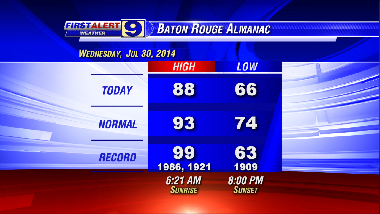
As we anticipated yesterday, local humidity began a slow, upward climb today, although most communities managed to have one more day with dew points in the 60°s -- rather comfortable by Gulf Coast summer standards. In addition, a fairly persistent cloud deck during the morning slowed the morning and mid-day warm-up, but the clouds cleared for the afternoon allowing most WAFB neighborhoods to reach the 90°s today. But all in all, not a bad weather day to close the month of July.

Humidity will continue a slow rise through the night and into Friday. The clouds return later this evening and stay with us tonight and into the early morning. We can’t rule out a shower or two overnight, but the vast majority stay dry. Some northern WAFB communities may see one more round of lows in the upper 60°s for Friday’s wake-up, with most around the Red Stick bottoming out near or around 70° for the early morning. Our Friday forecast turns ‘wet’ by the afternoon for many: we’re going with scattered showers and a few t-storms for the afternoon and early evening. And we keep rain in the weekend too, with rain chances for your backyard running at about 50/50 or better for both Saturday and Sunday. Now, to be clear: we don’t expect these to be all-day rains, just be prepared for periods of rain sometime during the day -- especially in the afternoon and early evening hours. 

Nope -- not a very pretty weekend ahead. 

Along with the elevated rain chances for the weekend, typical summer heat-and-humidity will be back to something closer to normal too. We’ll go with lows around the Red Stick in the low 70°s for Saturday and Sunday, with highs for both days in the upper 80°s to low 90°s depending on when the rains arrive in your neighborhood each day. What’s more, our latest extended outlook keeps our local weather rather unsettled through the middle to end of next week, with scattered mainly-afternoon rains posted for each day.


That big blob of rain to our north and northwest continues its approach through the night and into Friday. At the same time, a somewhat diffuse frontal boundary will meander over the southern parishes. Add in the increasing low-level moisture and we have the ingredients for rains for the next couple of days. In fact, the entire mess lingers into next week: the front continues to meander over and near the coast while additional upper-air disturbances float into and near the lower Mississippi Valley from the west and northwest. We don’t expect anything along the lines of a severe-weather outbreak, just more days where you’ll want the umbrella nearby ... or you try to plan your activities around the raindrops.

In the tropics, ‘Invest 93L’ keeps hanging on -- albeit it seems just barely at times. The tropical disturbance continues to pull ‘dry’ air into its core, really putting a stop to any serious chance for convection (thunderstorm activity) to wrap around its center. Satellite imagery still showed a pretty good low-level spin through much of the day, but without the thunderstorms it won’t get ‘upgraded’ to tropical cyclone status (a depression or tropical storm). The National Hurricane Center (NHC) has been waffling over the past 24 hours on 93L’s development potential, with their latest numbers showing a 70% chance of development in the next two to five days.


For us, 93L is way too far to the east to worry about for now. Even if 93L were to demonstrate a dynamic burst of energy over the next couple of days, it won’t be an issue for any part of the U.S. until next week. So relax ... the First Alert Storm Team will watch 93L for you.

Wednesday, July 30, 2014

One More Comfortable Morning

By Jay Grymes & Steve Caparotta


WAFB First Alert Quickcast:

- another comfortable night and Thursday wake-up ahead
- humidity starts creeping back on Thursday with a slight chance of afternoon showers
- scattered-to-likely rains for Friday and the weekend
- still tracking a struggling 93L in the Atlantic

A fine morning indeed to start Wednesday and the afternoon followed suit. With highs in the upper 80°s to near 90°, sure … it was hot, especially in the direct sunshine. But if you spent much time outside today you certainly noticed the lower humidity. Even the mid-day heat seemed tolerable, making for a pretty nice summer day across the WAFB viewing area. Too bad more July and August days can’t be like today, eh?


But, alas, all good things come to an end. We’ll enjoy one more nice evening and overnight, with Red Stick wake-up temperatures on Thursday in the 60°s once again. But through the day, you’ll likely feel the humidity on a slow rise. It won’t get uncomfortably sticky on Thursday, just not as ‘dry’ of a feel to the air like we enjoyed today. And with just a touch more humidity and the stalled, meandering coastal front lingering in the region, we’ll add in a slight chance for some afternoon showers on Thursday -- say, around a 20% chance or so.

Then it’s back to Gulf Coast summer reality. We aren’t talking about all-day rains, but our forecast calls for a return to scattered-to-likely (mainly-afternoon) showers and storms for the viewing area on Friday, Saturday and Sunday. In addition to the wetter pattern into the weekend, Gulf humidity will be back to normal and daytime temps will run in the upper 80°s to low 90°s. Yes, a return of a more typical summer weather pattern for the region.


As for the tropics, what appeared destined to become a tropical cyclone (depression or tropical storm) yesterday continues having a tough time getting its act together -- not that we are complaining. ‘Invest 93L’ -- located roughly 1000 miles east of the Lesser Antilles -- continues to show a decent spin, especially for a system so close to the equator (storms typically need to be north of 10°N latitude to develop good rotation).

However, 93L is being held in-check by the entrainment (pulling-in) of dry air to its north. In effect, we have a system that shows ‘spin’ but can’t develop enough organized convection (thunderstorm activity) around its core to get an upgrade (TD or TS status). In fact, 93L is looking less developed today than yesterday. Still, the National Hurricane Center (NHC) keeps 93L with a 50% chance of development in the next two to five days.


So we’ve got a fair amount of uncertainty regarding the intensity forecast of 93L. The general ‘consensus’ of the computer models suggests that a slowly-organizing/intensifying 93L moves towards the Leeward Islands (the northern islands of the Lesser Antilles) over the next two to three days, then near or north of Puerto Rico and eventually towards the Bahamas by Day 5.

Tuesday, July 29, 2014

Enjoy the Dry Air While You Can!

By Jay Grymes & Steve Caparotta


WAFB First Alert Quickcast:

- welcomed break in the humidity for today & Wednesday
- scattered rains return for Thursday, then scattered-to-likely into the weekend
- watching a healthy-looking disturbance in the Atlantic

It took a little longer this morning to clear the clouds out of the Baton Rouge skies, but by mid-day things were looking mighty fine.

Our third ‘cool’ front for July? Even if this month’s frontal passages didn’t knock temperatures way down, our three July fronts delivered a nice drop in humidity levels for most of the viewing area. And while we’ve had plenty of 90° days during July (today makes 21), the fronts have contributed to a July that will wind up cooler-than-normal – uh, not that you would really notice.

And while we won’t call July fronts rare, three distinct frontal passages in July is certainly not normal. The ‘cool’ fronts pushed through metro Baton Rouge on:
- the pre-dawn hours of July 3rd, while we watched Hurricane Arthur slide up the East Coast, 
- just after midnight on the morning of July 16th, and 
- near sunrise this morning.

And technically, there was another ‘cool’ front passage on the morning of the 20th, but this was really the lingering boundary from the July 16th frontal passage which had stalled and then meandered along the coast for several days.

And by the way, we admit that we’re being a little loose with the weather terminology. Many weather purists would content that there is no such animal as a ‘cool’ front -- that they are all ‘cold’ fronts. But down here, summer ‘cold’ fronts are far from ‘cold’ -- in fact, most aren’t even ‘cool’! Yes, they generally deliver a drop in temperatures but only by a few degrees. The real delight in our summer ‘cool’ fronts is the drop in humidity that they provide, albeit rather brief in most instances. So calling it a ‘cold’ front seems a little silly along the Gulf Coast ... maybe we should call it a low-humidity front?

No, we’ll stick with ‘cool’ front -- you know what it means … and so do the purists!

Sadly, as we just mentioned, the effects of these cool fronts are usually short-lived and such will be the case this go-around. We’ll enjoy the dip in humidity through the night and into Wednesday, but by Thursday our familiar Gulf humidity will start creeping back into the viewing area. As is so common in mid-summer, today’s front won’t make it very far south, with the guidance suggesting that it will stall and meander near the coast or over the southern parishes for the next few to several days. The increasing low-level moisture will combine with daytime heating and the added lift provided by the meandering front to generate isolated to scattered, mainly-afternoon rains for Thursday, with even better rain chances for Friday and the weekend. 


In the tropics, ‘invest 93L’ seems destined to become a tropical cyclone (depression or tropical storm) in the next day or so. As of this afternoon, the National Hurricane Center (NHC) has 93L posted with a 70% chance of development in the next two days (and an 80% chance over the next five days). Satellite imagery today shows a system with decent central spin and some modest banding features. On the other hand, 93L is still dealing with some fairly persistent wind shear and suggestions of ‘dry air’ intrusion from the north. All that said, we think it likely that 93L gets a ‘number’ (tropical depression) or a ‘name’ (Bertha, a tropical storm) by sometime tomorrow given today’s trends. 


As for 93L’s destination, it is far too early to rule-out a visit to the Gulf, but almost all of the forecast guidance keeps a developing 93L in the Atlantic.

Monday, July 28, 2014

Cool Front Ushers in Drier Air

WAFB First Alert QuickCast:
- cool front moves through tonight
- lower humidity, mainly dry next couple of days
- rains return late in the week

Overall, it’s been a relatively mild summer locally, but we have seen a full dose of heat and humidity over the last several days. However, some relief is inching closer this evening in the form of a cool front.

Scattered showers and t-storms along the front as of early evening should begin to dissipate later tonight. The front slips through overnight and should be to the coast by the time most of us wake up on Tuesday morning. So, as you head out on Tuesday, you should notice a less muggy start to the day. And humidity will continue to drop through the day, making an otherwise warm afternoon feel a bit more comfortable than recent days.


I’m going with a mainly dry forecast for Tuesday and Wednesday as the front drops to the coast and drier air filters into most of the region. Afternoon highs will still be near or above 90°, but the much drier air should result in rather pleasant days by late July standards.

Dry weather doesn’t last long as an upper-air disturbance moves in from the northwest and interacts with the stalled front. Set rain chances around 30% by Thursday, with 50/50 chances from Friday into the weekend. A small silver lining is that high temperatures may remain a few degrees below normal into the weekend.


Finally, we’re tracking a rather healthy tropical disturbance well out in the Atlantic. The National Hurricane Center is giving the system a 50% chance of development within the next 2 days and a 70% chance of development within 5 days. Guidance indicates the system could be near the northern Lesser Antilles (eastern Caribbean) by Friday or Saturday, so we’ve still got *plenty* of time to monitor its progress.


Friday, July 25, 2014

Hot, Mainly Dry Weekend

By Jay Grymes & Steve Caparotta


WAFB First Alert Quickcast:

- hot & mainly-dry through the weekend
- an approaching ‘cool’ front next week?

Our thinking hasn’t changed much over the past few days. Our “isolated” coverage today was along the lines of what we expected and we think it will be even drier through the weekend. We’re going with rain chances at 20% or less for Saturday and spotty showers at best for Sunday. 

So it’s shaping up to be a “sunscreen” weekend for those that take advantage of a pair of mainly-dry days. But be careful in the heat, whether it’s yard work duty, around-the-house projects, a day on the links, or some “me time” in the boat. We’re looking at highs in the low to mid 90°s for both days -- a forecast that calls for two afternoons that may rank among some of the ‘hottest’ days of the summer so far. 

You know the routine: lots of water and breaks in the shade. These are the kind of days that can keep our area EMS professionals busy with heat-related calls.

The heat-maker? That upper-level ridge that we’ve been talking about for the past week. Although it remains centered to our west, the ridge (high-pressure aloft) will continue to expand eastward into the weekend. That will put us under the eastern flank of the “heat dome” -- maybe not enough to totally shut-off rain chances but certainly enough to chop the rain chances down to 20% or less for Saturday and Sunday. 

As we head into next week, the ridge will again retreat to the west as an upper-trough (southward dip in the jet stream) digs into the eastern half of the country. And for now at least, our guidance into next week is showing signs of that trough helping to drive a cool front into the viewing area around Tuesday. The NWS Weather Prediction Center currently shows the front digging southward to the coast and then lingering there into Friday. That scenario means two things: increasing rain chances with the front’s approach and passage and then a break in the humidity for a couple of days with highs possibly topping out in the 80°s.


Now, we must admit that these 5- to 7-day summer frontal forecasts often don’t pan out, with the proposed front stalling before arriving in south Louisiana. But the guidance has been hinting at this possibility for a couple of days now, so we’ll remain cautiously optimistic about a modest break from our usual summer heat-&-humidity sometime next week.

In the meantime, all is quiet in the tropics ... quoting the National Hurricane Center: “No New Tropical Cyclones Are Expected to Form During the Next 5 Days.”

Thursday, July 24, 2014

A Little Drier .. and a Little Hotter ..


WAFB First Alert Quickcast:
- getting even “drier” in the coming days
- could see some mid 90°s over the weekend
- all “quiet” in the tropics

Yesterday we mentioned the slow breakdown of the upper-low that has been skirting from east-to-west along the Gulf Coast .. and as of this afternoon that feature is just about gone. What we did see in the way of rainmakers today was a bit of a combination of the last “hello” form the upper-low -- mainly over Acadiana -- and something a little more like a summer sea-breeze for the southeastern parishes.

As is usually the case at this time of year, the area rains will dissipate as we lose the energy of daytime heating. So it’s fair skies tonight and into Friday morning, with sunrise temperatures in the low 70°s for metro Baton Rouge. As we head into Friday afternoon -- and throughout the weekend -- the upper-level ridge to our west will expand and shift a bit eastward. That means its influence on our regional weather will increase in the coming days.

You know that ridges aloft (upper-level high pressure) tend to inhibit vertical cloud growth. In simple words, not only does upper-air ridging reduce rain chances, but it usually means more sunshine. And in the summer, more sun often means higher temperatures.


We won’t go completely “dry” over the next few days. In fact, I must acknowledge that our in-house RPM model wants to make things rather wet for Friday, apparently picking up on a weakness along the Gulf Coast under the eastern fringe of the upper-air ridge. But I’m not buying that, at least not the RPM’s 40% to 50% coverage for Friday afternoon -- nor are some of our other reliable short-term models. So I’m going with rain chances at about 20% or so for Friday, then on the order of 20% for Saturday too. I expect the ridge to be most dominant by late Saturday into Sunday, so for Sunday, I’m thinking rain chances at 20% or less.


Bottom line: the weekend is looking pretty good for some outdoor fun or work, but be ready for temperatures in the low to mid 90°s. Heading into next week, the upper ridge begins to shrink and retreat back to the west again, along for increasing rain chances. In fact, some of the extended guidance is trying to drive a summer ‘cool’ front down to the Gulf Coast around mid-week. Nothing to get excited about just yet -- that’s a little too far down the road for confidence -- but it will certainly be something to watch.


And in the tropics, there are a couple of weak waves floating in the Atlantic -- one being the remnants of TD #2 -- but that’s about it. Neither wave shows any potential for development in the near-term. So, no threats for now and none anticipate by the NHC in the next five days or more.

Wednesday, July 23, 2014

 
- afternoon showers and storms will subside into the evening
- rain chances decreasing in the coming days
- “Goodbye” to T.D. #2
 
 
The upper low that we’ve been tracking the past few days made its way over southeast Louisiana today, bringing better rain chances with it. While most of the action was along the coast and over the coastal waters this morning, daytime heating added just enough “umph!” during the afternoon to join up with the low and kick-off scattered afternoon showers and storms over the region. We expect the rains to subside into the evening as we lose the solar energy, with a quiet night for most WAFB neighborhoods.
 
After a mainly-dry start to the day with morning lows in the low 70°s, afternoon showers and a few t-storms return to the viewing area for Thursday. But unlike earlier today, we’ll set rain chances for Thursday at only 30% or so -- less coverage in general. The rationale is that the upper-level low currently nearly overhead will shift a bit to the southwest -- and more importantly – will become “stretched” and less defined. In effect, it will lose its impact on the local weather, allowing the broad upper-level ridge over New Mexico and west Texas to re-expand eastward and become a more dominant factor in our regional weather.
 
 
Since we’ll still be on the eastern fringe of the upper-high rather that underneath it, the ridge won’t shutoff rain chances, but it will inhibit development on Thursday and become even more dominant for Friday and the weekend.
 
 
As a result, we’ll go with rain chances at 20% or less for Friday, Saturday and Sunday - - and possibly include Monday too. But you know the drill: high-pressure aloft (upper-level ridges) mean less clouds and reduced rain chances, but the increased sunshine usually means a bit of a warm-up. We’re expecting low to mid 70°s for morning starts by Friday and into the weekend, with afternoon highs in the low 90°s for most WAFB communities, while a few could sneak into the mid 90°s on Saturday and Sunday.
 
 
“Goodbye, T.D. #2 … and good riddance too!” T.D. #2 succumbed to wind shear and ‘dry’ air and was downgraded to a remnant low at 10am this morning. While #2’s “bubble” of clouds is still evident on satellite imagery, the associated convection (thunderstorm activity) has faded and there is no evidence of a low-level circulation. The end of T.D. #2 came a little more quickly than had been expected by the National Hurricane Center experts, but as you recall there was never any perceive threat for the Gulf of Mexico. But let’s remember, we are still early in the Hurricane Season, and nearly 70% of Louisiana’s past tropical ‘visitors’ came during August and September.

Monday, July 21, 2014


WAFB First Alert QuickCast:
- mainly dry for Tuesday
- better rain chances for Wednesday & Thursday
- watching T.D. #2 in the tropical Atlantic

The weekend didn’t turn out quite as wet as we expected, but it was far from a ‘pretty’ Saturday and Sunday either. However, for most WAFB neighborhoods, we had a little opportunity for Friday’s big rains to run-off and sink-in.

The good news is that today was -- and tomorrow should be --mainly-dry days around the viewing area. Note that we said “mainly-dry,” which means we can’t rule out a shower or two, especially during the mid to late afternoons. One thing seems certain: the lawns and the mosquitoes are happy. (If you get a few minutes,“walk your yard” and dump any unintended containers holding water. This can be a great lesson for the kids too.)


But with less cloud cover and reduced rain chances comes a return of full-bore summer heat. After a morning start in the low 70°s for Tuesday, most WAFB neighborhoods will see highs in the low 90°s -- in fact, we won’t be surprise to see a couple of communities hit the mid 90°s. And as you know, with our Gulf air in place, that translates into Heat Index readings (‘feels like’ temperatures) that will peak around 100°or so. And remember, the Heat Index applies to the shade -- in direct sunshine, the Heat Index can go up another 10° to 15° under the right conditions. (So please be careful in the heat.)


An upper-level ridge to our west will help maintain a northwesterly flow at the upper levels and keep a bit of a lid on the atmosphere through Tuesday -- hence, our forecast for “mainly dry.” However, as we head into Wednesday, the guidance is hinting at a weak mid-level low moving into the central Gulf Coast region from the east. That low will provide enough lift to generate afternoon rains for Wednesday and Thursday before exiting the area. At this time, we’ll go with scattered showers and t-storms -- mostly the afternoon variety -- for both days. For Friday and the weekend, it looks like it might be a little drier, with rain chances currently posted at 20% to 30% for the three days.

And in the tropics? The National Hurricane Center (NHC) is has upgraded ‘Invest 92L’ in the central tropical Atlantic to Tropical Depression #2. The current official forecast keeps T.D. #2 on a west-to-WNW track over the coming days without further intensification. And more importantly, the NHC has T.D. #2 fizzling out near the Lesser Antilles on Thursday, ripped apart by strong wind shear centered over the Caribbean. The bottom line: T.D. #2 does not appear to be a threat for the Gulf.


Tuesday, July 15, 2014

Beautiful Day Ahead on Wednesday!

By Jay Grymes & Steve Caparotta

WAFB First Alert QuickCast:

- front moves through the region later this evening
- clearing and much less humid for Wednesday
- rains return for the latter half of the week
The ‘cool’ front we’ve been talking about for the last several days is still on track to arrive in the viewing area later this evening and makes its way south and into the coastal waters tonight and into Wednesday morning.  
And of course, the rains will make for a messy evening commute.  However, once the front moves through, we’ll get a nice break from the normal summer humidity.  Too bad the respite will be rather short.
We’ll keep isolated showers in the overnight forecast, mainly due to rains along the coast as the front sags south over the northern Gulf.  By Wednesday morning, skies should be clearing nicely for the Red Stick with morning lows in the upper 60°s for the northern half of the WAFB viewing area.  Mostly sunny skies will mean Wednesday afternoon highs up near 90° for many of us, but the ‘continental’ air mass in place will mean dew points in the low to mid 60°s for many of us tomorrow.  For south Louisiana, that is unusually ‘dry’ air and should make for a fairly comfortable day by July standards, even with those summer-like highs.
Much -- maybe even most -- of the WAFB viewing area will visit the 60°s once again for Thursday morning, but during the day the front will display a steady northward retreat.  By Thursday afternoon and evening, our typical humid Gulf air mass will be back in place.  In fact, we’ll even add in a slight rain chances -- at 20% to 30% -- for Thursday afternoon and evening as the unstable Gulf air displaces the drier air from the north.
Our forecast turns especially wet for Friday and the weekend: we’re going with rain likely for all three days.  What’s more, while we’re not calling for day-long rains over the three-day period, these won’t be ‘afternoon-only” rainy days either.  Although the majority of the rains will be during the latter half of the day, showers are likely to start popping up well before the lunch hour on all three days.
After a somewhat early start to the 2014 Hurricane Season -- thanks to Arthur on July 1st – all has remained “quiet” in the tropics since ... and there are no suspect areas for potential development through the next three to five days, at least.

Monday, July 14, 2014

More Wet Weather on Tuesday

By Jay Grymes & Steve Caparotta

WAFB First Alert QuickCast:

- better rain chances for Tuesday
- another July cool front at mid-week
 
Although today’s storms were somewhat limited in areal coverage, a few of them showed goodly amounts of lightning as they bubbled up.  They included a “healthy” thunderstorm that rolled right over downtown Baton Rouge between 3:15-3:45pm, delivering a little rain to our WAFB studio.
 
Yet the majority of WAFB communities stayed dry through Monday afternoon and evening.  However, the WAFB First Alert forecast for Tuesday shapes up to be considerably different. 
 
A July ‘cool’ front continues to sag southward towards the Gulf Coast.  It doesn’t arrive in the WAFB area until very late Tuesday or Wednesday morning, but it will be close enough on Tuesday afternoon to add lift to an already unstable air mass.  The result: our Tuesday afternoon and evening forecast reads “showers and t-storms likely.”  In fact, while we are not expecting a widespread severe weather outbreak, we’ll be on-guard for some strong to isolated severe storms. 


Tuesday’s action should take much of the stormy ‘punch’ out of the air mass as the front sags southward and stalls over the coastal waters by Wednesday afternoon.  That should mean a “drier” feel to the air on Wednesday as a continental air mass makes a brief visit to the viewing area.  Unfortunately, this frontal passage won’t be quite as dramatic as the one we enjoyed over the July 4th holiday weekend.  The air this go-around won’t get quite as cool and it doesn’t look like a complete dry-out either -- we’ll carry 20% to 30% rain chances for Wednesday and Thursday.  What’s more, the front will begin a retreat to the north as a warm front on Thursday.  
 
By Friday, we’ll be back in the “warm sector” (the south side of the front with moist and unstable Gulf air in place), and that will mean a return to increased rain chances.  In fact, we’re calling for 50% to 60% rain chances for Friday, Saturday and Sunday -- so it’s not looking like a very pretty weekend ahead right now.

 
But hey!  Two cool front in the month of July is far from the norm, so let’s enjoy the good fortune for now.  And here’s a bit of more good news: all quiet in the tropical Atlantic and no signs of development potential through the upcoming week.

Thursday, July 10, 2014

A Bit Drier into the Weekend

By Jay Grymes & Steve Caparotta


WAFB Storm Team QuickCast:

- pattern turns a little ‘drier’ for the next several days
- some may flirt with mid-90°s over the weekend

Take a closer look at the radar animations this afternoon and early evening and focus on the movement of the showers and storms. The movement today was different from the past two days. 

On Tuesday and Wednesday, we saw a number of storm clusters moving from the north or northwest towards the south and southeast. As we’ve mentioned in the past, the storms with more of a north-to-south motion often display greater lightning activity than storms moving from the Gulf inland. That south-to-north (or SW to NE) was the today’s pattern compared to the two previous days. 

Yet a look at the motion over the broader region this afternoon still shows active storm clusters by-passing Louisiana to the north and east and heading into the southeast states, continuing with a NW-to-SE motion, running in the flow of the upper-level trough positioned to our north and northeast. But for our area, today’s storms had more of a “sea breeze” appearance, a pattern more typical for the summer season along the central Gulf Coast.

We expect high pressure to become a more dominant player in our local weather over the next few days -- that means we’ll back down on the rain chances. Now do understand, we are not talking about out-and-out entirely dry weather, but we’ll run with rain chances in the 20% to 30% range for Friday, Saturday and Sunday -- down from the 30% to 40% numbers we’ve been posting for the weekend over the previous few days.

Of course, at this time of year lower rain chances usually mean less cloud cover -- and that means more sunshine and higher afternoon temperatures. In fact, much of the guidance is calling for highs in the mid 90°s for most of our viewing area for the upcoming weekend. That said, while we won’t be surprised to see some communities reach 95° or more over the weekend, we’ll call for highs a couple of degrees lower than that for most WAFB neighborhoods. But let’s face it: what is the ‘real’ difference between 93° and 95°?


Into the extended outlook, we’re getting some hints at another mid-summer cool front trying to make its way south and into the northern Gulf. Frankly, we are always a little skeptical of these longer-range projections: too often, the fronts fail to develop the southward momentum suggested by extended-outlook forecast models. But it does look as if a front could at least get close enough to add to the local instability and lift. As a result, we’ll look for improved rain chances by the middle of next week. Let’s see if it really pans out.

And in the tropics, the National Hurricane Center and the U.K. Meteorological Office agree that there are no potential developments in the works for at least the next four or five days.

Wednesday, July 9, 2014

More Rain on Thursday

By Jay Grymes & Steve Caparotta
First Alert QuickCast:
- rains tapering off later this evening, but keep the umbrella handy through the weekend
For the second day in a row, some “hot” thunderstorms generated very active cloud-to-ground lightning strikes during the afternoon.  Although not quite as energized as Tuesday’s systems, once again we watched a band of storms sag from north-to-south across the metro area.  Today’s storms arrived a little earlier in the afternoon -- good news for the Baton Rouge evening commute since the main action had cleared most of the Red Stick region before the 4 p.m. rush hour. 
As is typically the case in the summer, loss of daytime heating means that the area storms subside into the evening, although we will keep a very slight chance of showers in the forecast through the night, especially closer to the coast.  Metro area sun-up temperatures on Thursday will run in the low 70°s under mostly cloudy skies -- and like earlier this morning, we’ll anticipate a few morning showers along the coast again.  For the afternoon, it’s back to scattered showers and storms, as we seem to have locked into a repetitive daily pattern.  For Thursday, expect daytime highs for most WAFB neighborhoods to reach the upper 80°s to low 90°s.
Why so active?  Warm and moist Gulf air is the major player.  As we’ve mentioned before, warm-and-moist air is unstable, which means it is ready and willing to rise.  In the simplest terms, any significant daytime heating adds to the instability – and the more unstable, the faster the air will rise.  As the moisture in the warm air rises it cools and condenses, forming clouds and raindrops.  The more lift, the more (and faster) that moisture is added to the developing clouds.
We’ve been getting a little extra help over the past couple of days thanks to upper-air disturbances tracking over the region.  These are low-pressure areas traveling in the mid to upper levels of the atmosphere that contain pools of cold air within them.  The extra-chilled air aloft helps get the low-level unstable air rising even more quickly and in greater amounts.  Plus the sub-freezing air at higher elevations encourages hail and lightning development.  The result: thunderstorm outbreaks like we’ve had the past couple of days.
Once a round of storms rolls through the area, it tends to use up the available storm energy and temporarily stabilizes the local atmosphere.  However, if the day’s storms go by early enough in the day and the sun breaks out again and re-heats the air, you can get a second outbreak going.  Fortunately between yesterday and today, storms were late enough in the afternoon and the cloud deck lingered long enough that there was no opportunity for a Round #2.
All in all, our forecast stays fairly consistent right into and through the weekend: morning lows in the low to mid 70°s, afternoon highs in the upper 80°s to low 90°s, and scattered mainly-afternoon showers and t-storms each day.  Although rain chances for Thursday may be a tad higher at 50% or so, set those chances at 30% to 40% for the rest of the week and the weekend.
Still quiet in the tropics, with no real threats for development anywhere in the basin through the weekend.

Monday, July 7, 2014

Humidity, Rain Chances on the Rise

By Jay Grymes & Steve Caparotta


WAFB First Alert QuickCast:

- humidity slowly rising thru the work week
- rain chances also on the increase

Here’s our one last chance to gloat over the run of fine weather during the July 4th weekend. 
We won’t call it rare, but it certainly was outside the norms of summer -- and we’re unlikely to enjoy another string of days like that for quite some time. 

So we’re headed back towards Gulf Coast summer weather. The humidity has already begun a slow return and will continue to do so in the coming days. And as is typical for this time of year, it’s back to the afternoon ‘hit or miss’ thundershowers as the week progresses.

Now we admit that our forecast for the next day or two is a little drier than what our friends at the National Weather Service are posting. We’ll go with less than 20% coverage for Tuesday and about a 20% rain chance for Wednesday. The NWS has rain chances at 30% for both days. 


For the rest of the work week and the weekend, we are in agreement with the NWS: 30% rain chances each day. And we are just about in lock-step with temperatures each day too: low to mid 70°s for the morning minimums with highs in the low 90°s. Factor in the slow-but steady rise in humidity and by week’s end the peak afternoon Heat Index numbers will be flirting with the triple digits.

There’s really not much else to say. Now that Arthur is in the books, the tropics have turned quiet again, with no apparent threats for development any time this week.

So it’s back to the summer sweat: just please be extra careful if you are spending much time outdoors.

Sunday, July 6, 2014

Sunday (7/6) Tropical Update

Here is your tropical update for South Louisiana for July 6th, 2014.

5 DAY OUTLOOK:
Eyes across the Eastern Seaboard were on Arthur this 4th of July.  But Arthur is no more and no longer a concern.  But Arthur was climatalogically early.  On average we see our first named storm July 9th.  We also see our first hurricane on average August 10th.  Arthur beat both of those averages.  This is not to say that the early season projections of a less active / normal season are incorrect though.

As we move into July the formation zones for tropical disturbances doesn't change much.


The Gulf of Mexico, Western Caribbean and Western Atlantic are still prime areas for development.  What has changed is a farther north are in the Western Atlantic and now we look to the Eastern Caribbean Sea too.


Currently an area of low pressure sits off the coast of Georgia / Florida.  High wind shear should hamper any true development of this system.  The National Hurricane Center is giving this low pressure area a 10% chance of development in the next 48 hours.  That is about the true window this system has to become anything.  This system will take a similar track to Arthur moving north away from the Gulf of Mexico.


Our Tropical PrecisionCast shows that by 11 AM Monday a weak area of low pressure will sit off the coast of North Carolina.  The system then weakens as it moves into a more hostile environment in the northern Atlantic on Tuesday.

10 DAY OUTLOOK: ***(DISCLAIMER: 10 day outlook is a long range forecast and can change rapidly and should NOT be accepted as "gospel" truth but only a small possibility and something to keep an eye on over next several days.)***
The long range models indicate a quiet outlook minus this system previously discussed.  In other words no new systems are expected/indicated.

Thursday, July 3, 2014

Looking Good for the 4th!

By Jay Grymes & Steve Caparotta

WAFB Storm Team QuickCast:

- drier, less humid for Friday and the weekend
- Category 1 Arthur threatening the North Carolina coast
Today was noticeably quieter and less humid weatherwise compared to Wednesday … and our forecast gets even “drier” just in time for the fourth of July weekend!
The weak cool front that we’ve been talking about this week has made it into south Louisiana and our latest analysis shows that it has sagged into the coastal parishes, putting most of the WAFB region on the “drier” (less humid) side.  What’s more, guidance suggests that the front will sag even farther south and into the coastal waters over the next 24-36 hours before washing-out. 
That means highs in the low 90°s for the next few days, but more importantly, continued lower levels of humidity for WAFB neighborhoods for the next few days.  The “drier” (continental) air from the north will deliver dew point temperatures down into the 60°s -- quite “comfortable” by our summer standards. 
What’s more, as you know, the dew point is a rough guide to our summertime lows.  That means that some WAFB neighborhoods -- especially those along and north of the I-10/12 corridor -- can expect sunrise temperatures in the 60°s, a considerably change after our string of days with wake-up temps in the mid to upper 70°s for much of this week.
And, of course, the “drier” air also means a drop in rain chances.  But it is summer in the South, and so a spotty shower or two can’t be entirely ruled out.  So we’ll allow for a spotty afternoon shower or two on Titan9 Doppler for the next three days.  Frankly, let’s not even give it a thought for July 4th, and go with “spotty” for Saturday and Sunday.
As you expect, however, the low humidity doesn’t hang around long; by early next week our typical Gulf humidity will have pushed its way back into the viewing area.  So by next Monday, we’ll ease those rain chances back up to around 20% to 30% or so, and keep them running at around 30% through the middle of the upcoming work week.  But for now, we don’t anticipate a return to the mid 90°s any time soon.
As for Arthur, it has become a nerve-racking threat for North Carolina.  As forecasted, Arthur reached Category 1 strength this morning.  But Arthur has been slow to turn to the northeast as forecasted today, bringing the eye of the hurricane closer to the coast this afternoon than the official forecast track has been suggesting.  


Tuesday, July 1, 2014

Another Sizzler on Wednesday!

By Jay Grymes & Steve Caparotta

94° this afternoon, the highest reading of the year thus far … with a heat index above 100°!'


High pressure remains in charge of our weather for the time being, which means continued hot-and-humid yet mainly-dry weather for Wednesday afternoon. We’ll open Wednesday morning with fair to partly cloudy skies with a muggy mid 70°s for the Red Stick, then heat-up into the low to mid 90°s for most of the WAFB viewing area for the afternoon. Once again, the humidity will produce ‘feels like’ (Heat Index) numbers up around the triple digits during the peak of the day. Now, given that it is summer in south Louisiana, we can’t completely exclude a rogue shower or two on Titan9 Doppler radar on Wednesday afternoon, but don’t count on it for your backyard.

A trough over the central U.S. continues to push southward, driving a summer-season cool front towards the lower Mississippi Valley. It’s certainly not common, but during our summers, a few of these mid-summer fronts try to make it into the Gulf. Our latest guidance suggests that this front will make it into south Louisiana by the end of the week, then likely stall and wash-out over the Gulf Coast states. That should provide a slight drop in the humidity for the coming weekend. However, the trough and cool front will also put the squeeze on our current high-pressure pattern, taking the ‘lid’ off the atmosphere and allowing for better rain chances on Thursday and Friday.

We’ll go with rain chances at 30% to 40% (scattered) for Thursday and Friday, then drop them to 20% or so for the weekend. And in case you are wondering, we think that any shower and t-storm action that does develop on Friday should be out of the way by the time the fireworks begin flying, so don’t change your Friday evening plans.


In the tropics, T.S. #1 was upgraded by the NHC to T.S. Arthur this morning at 7AM, the first ‘named’ storm of the 2014 season. Arthur is expected to drift just east of Florida’s Atlantic shoreline for the 12-18 hours before taking a turn to the north and then moving a little faster to the NNE. The official NHC forecast calls for slow strengthening as the system takes aim at the Carolina coast late Thursday into early Friday, with Arthur expected to reach hurricane status at about the same time. The forecast models are in very good agreement with this outlook, but we note that given these projections with Arthur paralleling the U.S. Eastern Seaboard, it would only take a modest westward shift to bring Arthur inland almost anywhere from Florida to Maine!