
 By Jay Grymes & Steve Caparotta
WAFB First Alert Quickcast:
- another comfortable night and Thursday wake-up ahead- humidity starts creeping back on Thursday with a slight chance of afternoon showers
- scattered-to-likely rains for Friday and the weekend
- still tracking a struggling 93L in the Atlantic
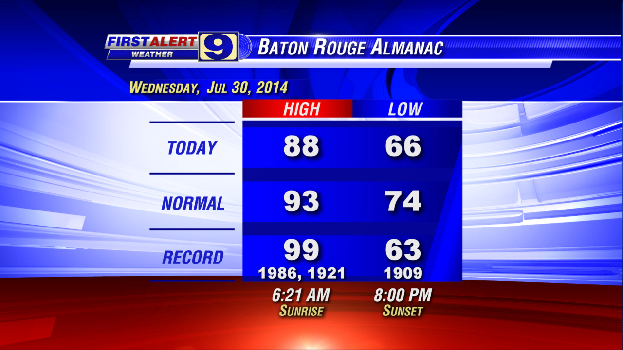
A fine morning indeed to start Wednesday and the afternoon followed suit. With highs in the upper 80°s to near 90°, sure … it was hot, especially in the direct sunshine. But if you spent much time outside today you certainly noticed the lower humidity. Even the mid-day heat seemed tolerable, making for a pretty nice summer day across the WAFB viewing area. Too bad more July and August days can’t be like today, eh?
But, alas, all good things come to an end. We’ll enjoy one more nice evening and overnight, with Red Stick wake-up temperatures on Thursday in the 60°s once again. But through the day, you’ll likely feel the humidity on a slow rise. It won’t get uncomfortably sticky on Thursday, just not as ‘dry’ of a feel to the air like we enjoyed today. And with just a touch more humidity and the stalled, meandering coastal front lingering in the region, we’ll add in a slight chance for some afternoon showers on Thursday -- say, around a 20% chance or so.
Then it’s back to Gulf Coast summer reality. We aren’t talking about all-day rains, but our forecast calls for a return to scattered-to-likely (mainly-afternoon) showers and storms for the viewing area on Friday, Saturday and Sunday. In addition to the wetter pattern into the weekend, Gulf humidity will be back to normal and daytime temps will run in the upper 80°s to low 90°s. Yes, a return of a more typical summer weather pattern for the region.

As for the tropics, what appeared destined to become a tropical cyclone (depression or tropical storm) yesterday continues having a tough time getting its act together -- not that we are complaining. ‘Invest 93L’ -- located roughly 1000 miles east of the Lesser Antilles -- continues to show a decent spin, especially for a system so close to the equator (storms typically need to be north of 10°N latitude to develop good rotation).
However, 93L is being held in-check by the entrainment (pulling-in) of dry air to its north. In effect, we have a system that shows ‘spin’ but can’t develop enough organized convection (thunderstorm activity) around its core to get an upgrade (TD or TS status). In fact, 93L is looking less developed today than yesterday. Still, the National Hurricane Center (NHC) keeps 93L with a 50% chance of development in the next two to five days.

So we’ve got a fair amount of uncertainty regarding the intensity forecast of 93L. The general ‘consensus’ of the computer models suggests that a slowly-organizing/intensifying 93L moves towards the Leeward Islands (the northern islands of the Lesser Antilles) over the next two to three days, then near or north of Puerto Rico and eventually towards the Bahamas by Day 5.
No comments:
Post a Comment