 A city and region on edge in the wake of historic flooding has quickly shifted focus to possible developments in the tropics over the last couple of days. We don't want another major weather event. We simply can't handle any more rainfall.
I've been flooded with questions about the future track of this disturbance passing through northern parts of the Caribbean as of Wednesday afternoon. Let's see if I can answer some of those questions and maybe even alleviate a little fear for those trying to recover.
Current State of '99L'
The Hurricane Hunters flew through '99L' for several hours this morning, finding tropical storm force winds in several spots. However, winds alone are not enough to upgrade a disturbance to a tropical depression or storm. By definition, there must also be a well-defined center of low pressure at the surface. The Hurricane Hunters were unable to find one. Satellite imagery has hinted at a center just northeast of Puerto Rico this afternoon, but even if that's the center, there appears to be a mid-level center (several thousand feet above surface) well to the southeast. And the main area of convection (t-storms) is separated from both centers. In short, '99L' is a bit of a mess right now.
Where is '99L' headed next?
From there, the forecast gets a bit more hazy as models wrestle with the strength of high pressure to the north of '99L' and the intensity of the system itself. A sampling of the numerous models we look at appears below.
Looks like everything keeps it east...why are we even worried?
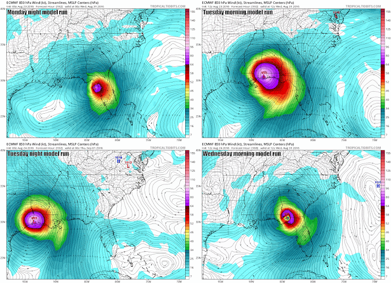
The animated gif below shows the last 4 runs of the Euro model. Notice how the forecasts went from the eastern Gulf in one run to Mobile in the next to the LA/TX border in another and back to the eastern Gulf in the latest. When models are behaving like windshield wipers, that decreases our forecast confidence.
One other thing I would tell everyone to watch. IF '99L' is able to get its act together around the Bahamas and south Florida, the models may be underestimating the strength of high pressure that will be to its north. Weaker high pressure allows the system to turn north sooner while a stronger high would keep it going west longer. As tropical systems intensity, they can sometimes 'feed' high pressure systems or make them stronger than anticipated.
Bottom Line
As it stands as of 3 p.m. on Wednesday afternoon, the overall threat to our area is still pretty low. I've seen some meteorologists saying that posting model runs or discussing scenarios is reckless at this point and just scares everyone. I see it differently.
We are a region that is limping along right now. While the threat is low at this point, potential impacts from this system are now less than a week away should it decide to head this way. Everyone should be prepared just in case and given what we're going through right now, I think an early heads up is needed now more than ever.
Stay safe...stay calm...and we will keep you updated on '99L' which could become Hermine in the coming days.


No comments:
Post a Comment