Monday, May 11, 2015

Keep an Umbrella Handy This Week

By Jay Grymes & Steve Caparotta


May 11th First Alert Quickcast:

- a wetter looking week ahead
- goodbye Ana!

A squall line rolling out ahead of a slowly advancing cold front delivered some strong storms to the northern portion of the WAFB viewing area during the early and mid afternoon hours. The storms came with locally-heavy downpours, frequent cloud-to-ground lightning and indications of hail on the order of 1” or more in diameter for a few spots. The active storms prompted the NWS to issue a handful of Thunderstorm Warnings for more than a half-dozen parishes and counties, in addition to a Tornado Warning for parts of Livingston and Tangipahoa parishes. As of this writing there have been no confirmed touchdowns in our viewing area although we did receive one report from a viewer of a funnel near the Holden area close to Warning time.


The stormy weather has passed and as we head into the evening the rains continue to taper off. We expect most, if not all, of the showers to have ended by the mid to late evening hours with a mainly-dry night ahead. However, we’ll remain under mostly cloudy skies, the air will remain rather muggy, and the damp air and wet ground should allow for the onset of at least some patchy fog. 

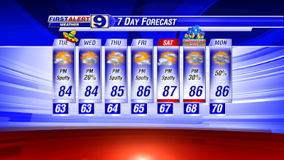
Tuesday morning will open with clouds, patchy fog, maybe a spotty shower and a muggy air mass with temperatures near 70° for metro Baton Rouge. We expect mostly cloudy skies through the morning, with rain chances on the rise as we head into mid-day. By the afternoon, we’re calling for a 50% to 60% rain chance across the viewing area. We could see one or two strong storms during the afternoon and can’t exclude the possibility of a Warning, but the threat for severe storms is certainly lower for tomorrow. With the cloud and rains, we’re expecting highs to top out in the mid 80°s for most WAFB neighborhoods.

The cold front that generated today’s squall line will sag southward into the southern parishes but then there for Tuesday and Wednesday before retreating to the north as a warm front. So don’t expect any relief from the humid Gulf air mass that has dominated our weather for the past couple of weeks.

While Tuesday looks rather wet, our forecast for Wednesday is considerably drier, with only a 20% to 30% chance of afternoon rains. For Thursday, we’ll ease the rain chances back to 40%, then return to 50% to 60% for Friday. Plan for mostly-dry but muggy mornings in the upper 60°s to near 70° for metro baton Rouge with patchy morning fog through the week. Highs will hover in the mid to upper 80°s, largely dependent on cloud cover and rain chances.


For the weekend, we’ve got scattered rains currently on the forecast board for Saturday with isolated-to-scattered rains for Sunday, with highs for both days in the upper 80°s.

As for T.D. Ana, the NWS Weather Prediction Center (WPC) has issued its last advisory as of 4:00pm this afternoon. Ana will continue to accelerate to the northeast while skirting the U.S. Mid-Atlantic Coast tonight. The WPC projects that Ana will be absorbed by an advancing cold front -- currently located to Ana’s west -- sometime tomorrow.

Friday, May 8, 2015

Warm, Mainly Dry into Mother's Day

By Jay Grymes & Steve Caparotta

WAFB First Alert Quickcast:

- only spotty afternoon showers through the weekend
- warm, humid Saturday and Sunday afternoons … feeling like 90°?

For most of the WAFB viewing area, it’s been more than 10 days without significant rain – a dry-out welcomed by many after the locally heavy rains and damaging storms on April 27th.  That same mostly-dry pattern we’ve seen the past many days will continue through the weekend.

Want a little rain?  Not to worry -- we’ve got rain in next week’s forecast, so let’s enjoy the drier pattern through the weekend and especially for Mother’s Day.

Our recent run of weather has been relatively pleasant but you’ve likely noticed the humidity.  That’s not going to change.  With afternoon temperatures sneaking up into the mid to upper 80°s, we’ve been flirting with Heat Index numbers near 90° -- such will be the case for both weekend afternoons.  Expect a little patchy fog for both mornings … just like we’ve seen the past few early mornings.  But the good news is that the weather cooperates for just about everyone on Mother’s Day.


By the way, a big “Thank You!” to all of our area Moms!

Heading into next week, the upper-air pattern will finally support the onset of rains around the area.  In fact, our current forecast calls for scattered rains for just about every day next week.  We’re not anticipating excessive rains, just days with Doppler radar showing lots of returns.

Through much of this past week we were anticipating a cool front making its way into the lower Mississippi Valley early next week.  Our latest guidance now seems to take that out of the outlook.  Instead, our warm-and-moist Gulf air will remain in place and get occasional boosts thanks to passing disturbances.  And no front means no significant drop in temperatures, and maybe more importantly, no drops in the current humidity either.  While our daytime highs may come down a couple of degrees next week, that will be due to the rains and added cloud cover.


The latest on Subtropical Storm Ana shows a system trying to complete a transition to a fully tropical storm.  That appears likely within the next 12 hours or so as convection tries to wrap around the core and the enlarged subtropical wind field continues to contract.  (Remember, subtropical systems tend to be more expansive but a little less energetic than their fully tropical “big brothers.”)

Ana is expected to continue a slow forward motion to the NW to NNW with a likely landfall along the Carolinas coast on Sunday as a “minimal” tropical storm (winds at about 40 mph).  After moving inland, Ana is then expected to get picked up in a strong southwesterly flow, take a hard turn to the northeast and eventually move back out over the western Atlantic.

While ‘she’ is not expected to be an especially destructive storm, Ana will probably make for a wet Mother’s Day weekend for both Carolinas.

For us?  Enjoy the weekend and be careful in the “almost summer” afternoon heat.

Thursday, May 7, 2015

Only Isolated Showers into the Weekend

By Jay Grymes & Steve Caparotta


WAFB First Alert Quickcast:

May 7th WAFB First Alert Quickcast:
- isolated showers into the weekend
- Invest 90L has an 80% chance of becoming Ana

Areas of dense fog developed during the morning drive as our muggy Gulf air mass reached saturation -- relative humidity at 100% -- across much of the area. Thankfully, the morning sun dispatched that fog fairly quickly.

After a string of mainly dry days, we saw a bit more action on Doppler radar today, although coverage was still rather limited. And what rains did develop this afternoon -- a result of our moist air and daytime heating -- die off into the evening. Look for fair skies by the evening with clouds and pockets of fog slowly returning after midnight. It should be a dry start for Friday’s morning drive and bus ride with temperatures in the upper 60°s.

It’s another warm and somewhat humid Friday afternoon on the way with highs in the mid to upper 80°s for the WAFB viewing area. Given the set-up, spotty-to-isolated showers can be expected for the afternoon but whatever does develop won’t last long -- let’s call it rain chances at 20% or less. All in all, looking good for Friday evening’s ‘Live After Five,’ LSU Baseball, or anything else around the area.


Saturday's forecast? Ditto on Friday: upper 60°s for sunrise with pockets of fog, afternoon highs in the mid to upper 80°s and rain chances at 20% or less.

What about Mother’s Day? If you’ve been following our forecasts this week, we’ve been generally going with a 30% chance of afternoon showers for Sunday. The news is a little better as of this afternoon: we’ll go with just a 20% chance of rain and a forecast for the day that is nearly a carbon-copy of Friday and Saturday.

After that very wet April, our recent run of mostly-dry days has been welcomed. But we don’t want to get too dry, and it looks like Mother Nature will accommodate. A storm system over the Central Plains this weekend will send a cold front our way for early next week. Plan for scattered rains on Monday with scattered-to-likely rains on Tuesday. The extended guidance is somewhat divided on what happens after that -- does the front sweep through far enough to deliver a noticeable cool-down and a return of dry days or does it linger in the region as a stalled front that keeps our weather unsettled? 


For now, we suspect only a limited drop in temperatures with this front and we are currently leaning to continued scattered rains for Wednesday and Thursday.

As for “Invest 90L” off the southeastern Atlantic Coast, the National Hurricane Center (NHC) has again increased the chances for tropical or sub-tropical development, now giving 90L an 80% chance of becoming Ana over the next two to 5 days (as of 12:45pm today). Based on the latest satellite presentations, it seems probable that the NHC will ‘upgrade’ 90L to Ana in the next two days and define it as a sub-tropical storm.

As a reminder, sub-tropical systems are hybrid systems caught midway between extra-tropical lows and fully tropical systems, showing some characteristics of both. While sub-tropical storms tend to be less energetic in terms of damage potential, they tend to be more expansive than tropical storms and hurricanes. Interests along the U.S. Eastern Seaboard -- especially the Carolinas -- need to pay close attention to this system, but it offers no threat to the Gulf. 

Wednesday, May 6, 2015

Slightly Better Rain Chances on Thursday

By Jay Grymes & Steve Caparotta

May 6th WAFB First Alert Quickcast:

- local weather status quo: isolated showers possible through Saturday
- “Invest 90L” no threat to the Gulf

Our recent set-up of mostly-dry days with isolated showers and highs in the 80°s continued today and is expected to hold through Saturday.

While the breezes may have done a number on your hair today, they are helping to make our warm and somewhat-humid afternoons reasonably comfortable.

We got a little cooler than expected this morning, with Metro Airport (BTR) dropping to a low of 61°, in part because we had less cloud-cover than expected.  For this afternoon, we picked up a couple of Doppler radar returns through the afternoon but it was very limited ... and anything that fell was generally on the light side with little if any thunder in our viewing area.

Our forecast for Thursday calls for a slightly higher chance for a backyard shower and we do expect both the morning lows and afternoon highs to be a smidge higher.  Let’s go with Red Stick area sun-up temperatures in the mid 60°s for Thursday morning and afternoon highs in the mid 80°s with a 20% to 30% chance of afternoon and early evening showers.

Friday and Saturday may be a slight bit warmer.  Plan for muggy mornings in the upper 60°s for both days, largely due to a slow-but-steady increase in dew point temperatures (a measure of low-level humidity).  Afternoons will be a little warmer and stickier too for most WAFB neighborhoods: we’ll go with mid to upper 80°s for both days.  As for rain chances?  20% or less for both afternoons.

For Sunday -- Mother’s Day -- we’ve been hovering in the 20% to 30% range for rain chances over the past several days and we’ll keep it there.  Plan for a muggier morning, with sunrise temperatures in the upper 60°s to near 70° for the Capital City and an afternoon high in the mid to upper 80°s.  What rain that does fall should be relatively short-lived, so stick with any outdoor plans that you have put together for Mom.


Headed into next week, we’re still anticipating a cold front to make its way into the lower Mississippi Valley, most likely arriving early Tuesday.  But the latest charts from the NWS Weather Prediction Center (WPC) suggest that the trailing end of that front may fizzle out before pushing through our viewing area.  We’ll go with scattered showers and t-storms for Monday and Tuesday for now, with the weather potentially remaining a little unsettled into Wednesday.  However, a fizzling front suggests no significant reduction in area temperatures, and maybe more importantly, no break from this week’s Gulf humidity.

As for the pre-season chatter about tropical development east of Florida?  Overnight the National Hurricane Center (NHC) labeled the area as “Invest 90L” (investigation area) and as of this morning the NHC significantly increased their forecasted development chances: 60% chance of development during the next two days and over the course of the next five days.  (The NHC’s 2:00pm update keeps those percentages at 60% for both the 2- and 5-day projections.)


As of this afternoon, there has been no confirmed center of closed circulation for 90L.  (As an aside, it is likely that when a surface low is confirmed it will be a non-tropical low.)  Until we have a closed low, forecasting the system’s track, intensity and even its potential evolution into a tropical structure is little more than educated guesswork based mainly on model projections.

In fact, the lack of a well-developed center is probably at least one reason why the NHC scrubbed the aircraft mission schedule for earlier today.  (Two flights are currently scheduled for Thursday with a third on the books for a pre-dawn mission Friday.)

Many, but certainly not all, computer models are ‘bullish’ on this system.  Residents along the Southeast U.S. coast- - from Georgia to the Carolinas - - should begin preparations for a potential landfall of either a sub-tropical or tropical storm by or even before the weekend.  If 90L does reach one of these stages, it would be named ‘Ana.’


Yes, it’s early but it’s not entirely rare for tropical storms to form before June 1st.  In fact, there have been pre-season storms (including hurricanes, tropical storms or sub-tropical storms) in 10 of the past 50 years, with two pre-season storms forming in 2012 (TS Alberto & TS Beryl).

Tuesday, May 5, 2015

No Major Changes Ahead...

By Jay Grymes & Steve Caparotta

May 5th First Alert Quickcast:

- isolated showers for Wednesday through Saturday
- an update on weather near Cuba and the Bahamas

Happy Cinco de Mayo!

As expected, it was a mainly-dry day today with just a few short-lived blips on our regional Doppler radar.  Highs climbed into the low to mid 80°s across the region for the afternoon. While dew points were in the low to mid 60°s, fairly persistent breezes through the afternoon kept the air reasonably comfortable, making for a nice May day.

Clouds will slowly increase late tonight and into Wednesday morning, with morning lows in the low to mid 60°s for most WAFB neighborhoods.

Wednesday will again be mostly dry across the area -- we’re going with a 20% chance of afternoon t-showers.  A modest mid-level “lid” on the atmosphere that inhibited showers today will weaken just a tad by Wednesday afternoon, allowing a few showers -- and even a pop or two of lightning -- to get going.  Like today, plan for highs in the low to mid 80°s for Wednesday afternoon around the region.  And like today, whatever showers do develop should be gone by sunset.

Our current forecast stays with spotty-to-isolated mainly afternoon showers for Thursday, Friday and Saturday -- rain chances at 20% or less each day.  However, a steady fetch off the Gulf will mean a slow increase in low-level humidity through the work week.  As the dew points rise, so will morning minimums.  In addition, the afternoons will get a tad warmer and more humid too. 

For Sunday, Mother’s Day, we think that the weather gets just a bit wetter: we’re posting a 30% rain chance for Mom’s afternoon.  Sunday won’t be a wash-out: more along the lines of a summer-type of day with hit-or-miss afternoon t-showers.  Stick with the BBQ plans.


The extended outlook into early next week features a cold front approaching from the northwest.  Yesterday’s guidance suggested a Monday arrival for the front.  However, today’s latest from the NWS Weather Prediction Center (WPC) delays the front until Tuesday.  The American GFS model is none-too-impressed by the front based on its latest rain projections, while the European ECMWF is a little more bullish with its rain forecast.  For the time being, let’s go with scattered rains for Monday and Tuesday.  We can fine-tune over the coming days.

So what about that broad area of messy weather extending from near Cuba to near the Bahamas?  Yesterday, the National Hurricane Center (NHC) gave the region a 30% (low) chance of development during the latter half of this week.  Today, the NHC ‘upped’ the 5-day chance of development to 40%, adding in a 20% chance for the next two days.


So what does all this mean?  Well, we could have a pre-season ‘Ana’ on the tropical board by the weekend.  Virtually all of the computer models are showing some type of low developing, although they differ in terms of intensity and location. 

Most importantly for our local interests: no matter what happens, this is not going to be a threat for us.

If you’ve been watching the satellite presentation over the past 24 hours or so, two things are apparent:  (1) while there are some guesses, there does not appear to be a clear-cut surface low anywhere in that mess and (2) there is a fair amount of SW-to-NE flow aloft.

Now, if this were a tropical system, those upper-level winds would be counter-productive.  But the consensus thinking is that any surface low that forms will be non-tropical, at least in the initial phase.  If that is the case, the upper-level winds might actually be beneficial by enhancing the vertical lift and deepening the low. 

The question then becomes, should a non-tropical low form, could it then start to morph into a sub-tropical (hybrid) system?

When we go back to the computer models, the answer appears to be leaning somewhere between possible to likely.  In other words, we’re still far from a sure thing here, but if the non-tropical low could form, drift north and then meander over the warm Gulf Stream waters, then we could have a set-up for a slow transition to something sub-tropical. 

The NHC still has an aircraft scheduled to visit the region tomorrow, although an official “invest” (area of investigation) has yet to be declared as of this writing.  Stay tuned!

Monday, May 4, 2015

Warm, Isolated Showers Through the Week

By Jay Grymes & Steve Caparotta

May 4th First Alert Quickcast:

- a mostly-dry forecast through the work week
- what’s up with the tropics?

We hope that you had at least a little time to enjoy the weekend weather -- a great way to start off the month of May.  And keep in mind, summer-like heat-and-humidity is just around the corner, so get outdoors while we can still enjoy these relatively comfortable afternoons.

Speaking of humidity, you may have noticed a slight uptick in that department through the day: not uncomfortable, but not “dry” either.  After opening May with Baton Rouge dew point temperatures in the low to mid 50°s, we were in the upper 50°s yesterday and those numbers have risen into the 60°s today.  That’s just about average for May in the Red Stick and still a far cry from the traditional summer dew points in the 70°s. 

So not summer-sticky just yet, but probably enough to get many of you to run the A/C to dry-out the air in your home.

An easterly wave (a surface trough of low pressure tracking from east-to-west) over the north-central Gulf provided sufficient lift today with our low-level Gulf moisture to generate a few showers and even flashes of lightning during the afternoon.  The wave will continue to the west through the evening, taking its influence on our local weather out of the picture.

After today, there are no major rain-making features that are expected to impact our local weather.  Surface high pressure will remain parked over the eastern U.S. into mid-week with the central Gulf Coast under a south-to-southeast low-level flow.  That means continued flux of Gulf moisture into our area.

Daytime highs for metro BR will hover around the mid 80°s for much of the week, possibly climbing into the upper 80°s for many WAFB neighborhoods by week’s end.  With the rising dew points thanks to southerly flow, morning lows will display a slow-but-steady rise through the 60°s.

We’re expecting a drier Tuesday compared to today, although a spotty shower or two can’t be ruled out.  Even without any significant weather features -- like surface fronts -- to provide lift for our muggy air mass, our daytime heating over the next several days should be enough to spawn a shower here and there each afternoon, especially closer to the coast.  Remember, warm-and-moist air is always ready to rise … and our daytime heating in the coming days should be enough to generate spotty to isolated pockets of brief rain each afternoon.

That means daily rain chances at 20% or less through the work week.  In fact, as of now, our next significant shot at area rains is not until Sunday.  


So ... about the tropical chatter you might have heard over the past few days.

Just about every major forecasting model is showing some sort of low-pressure area developing to the north of the Bahamas later this week.  An area of disturbed weather currently near Cuba is expected to track northeast and then turn north by mid-week.  There is a chance that this area could take-on tropical characteristics if it were to sit over the very warm Gulf Stream paralleling the U.S. Southeast Coast.

What kind of chance?  The National Hurricane Center (NHC) currently says a 30% chance over the next three to five days -- a low chance -- of becoming something tropical.  In fact, the NHC is suggesting that if it were to develop, it would probably be a sub-tropical storm. 


Sub-tropical storms are hybrid storms, caught somewhere between being non-tropical and fully-tropical systems.  Generally, sub-tropical storms tend to be less energetic than tropical storms, but tend extend over a larger area than their tropical cousins.  And just like tropical storms, they can produce strong winds, locally heavy rains and storm surge.

Interestingly, while the NHC is currently posting development potential at a low 30% later this week, they already have scheduled an aircraft reconnaissance for Wednesday on the presumption that something of interest will emerge north of the Bahamas by then. 

In the meantime, this is certainly not something for WAFB and other local interests to get concerned about.  Even if this system were to become a sub-tropical or tropical storm (it would be named ‘Ana’), it offers no threat to the Gulf.  Maybe more importantly for us, pre-season storms are not omens of an active season ahead.

Friday, May 1, 2015

Beautiful First Weekend of May!


May 1st WAFB First Alert Quickcast:

- great weather through the weekend
- rain eases back into the forecast next week

Another beauty and the great way to start the month of May. The evening will be just about perfect for anything: downtown BR’s Live-After-Five, dinner-and-a-movie, a walk around the block, or just a sit-down in the backyard.

And … it’s a sunscreen weekend ahead: plenty of sunshine for both Saturday and Sunday with morning starts in the mid to upper 50°s and afternoon highs in the low 80°s. Humidity stays on the low-side for both days, in part due to a weak, dry cool front that pushed through the area today.

Of course, this fine weather can’t last forever ... and with summer not too far down the road … we encourage you to make some plans to take advantage of it if at all possible.

As we head around the calendar corner into next week, winds will come around off the Gulf. That means a return of low-level moisture and slowly increasing rain chances too. The increase in moisture will be reflected by rising morning minimums and slight chances for mainly-afternoon showers through mid-week. Towards the latter half of next week, we’re anticipating highs to reach mid 80°s and noticeably higher dew point readings. Also add scattered t-showers to the outlooks by Thursday and Friday.


May 1 -- one month until the official start of the 2015 Atlantic Hurricane Season. We’ve reviewed several early-season projections from notable forecast groups … and the consensus calls for storm numbers to be below-normal this season. Two key reasons for that line of thinking are (1) the likelihood of a ‘moderate’ El NiƱo, which is associated with increased mid-level shear over the Atlantic basin and cooler-than-normal waters expected over the tropical and sub-tropical Atlantic Ocean.


However, as we often remind everyone, low storm numbers do not always translate into a reduced threat: 1957’s Audrey, 1965’s Betsy, and 1992’s Andrew all formed during seasons with fewer than nine storms. Indeed, at least one of the early-forecast teams has made note of the fact that while waters of the open tropical and sub-tropical Atlantic are cooler-than-normal, the western Atlantic (near the U.S. Eastern seaboard) and the Gulf of Mexico are abnormally warm. This is a set-up that could support rapidly-developing storms that provide much less lead time for warnings!

Then, to highlight this very point, you may have noticed Steve’s comments over the past two days regarding a potential for a tropical/sub-tropical/hybrid system to form somewhere north of the Bahamas around the middle of next week. In fact, both the American GFS and European ECMWF are suggesting this. 

We aren’t overly concerned ... and don’t want to make a big deal about it … but it is just nature’s way of sending us a reminder that it will soon be that time of year.

Oh, and speaking of May 1st, today marks the start of Louisiana’s Ozone Season too! We’ll be tracking the AQI daily through the next five months.