By Jay Grymes & Steve Caparotta
WAFB Storm Team QuickCast:
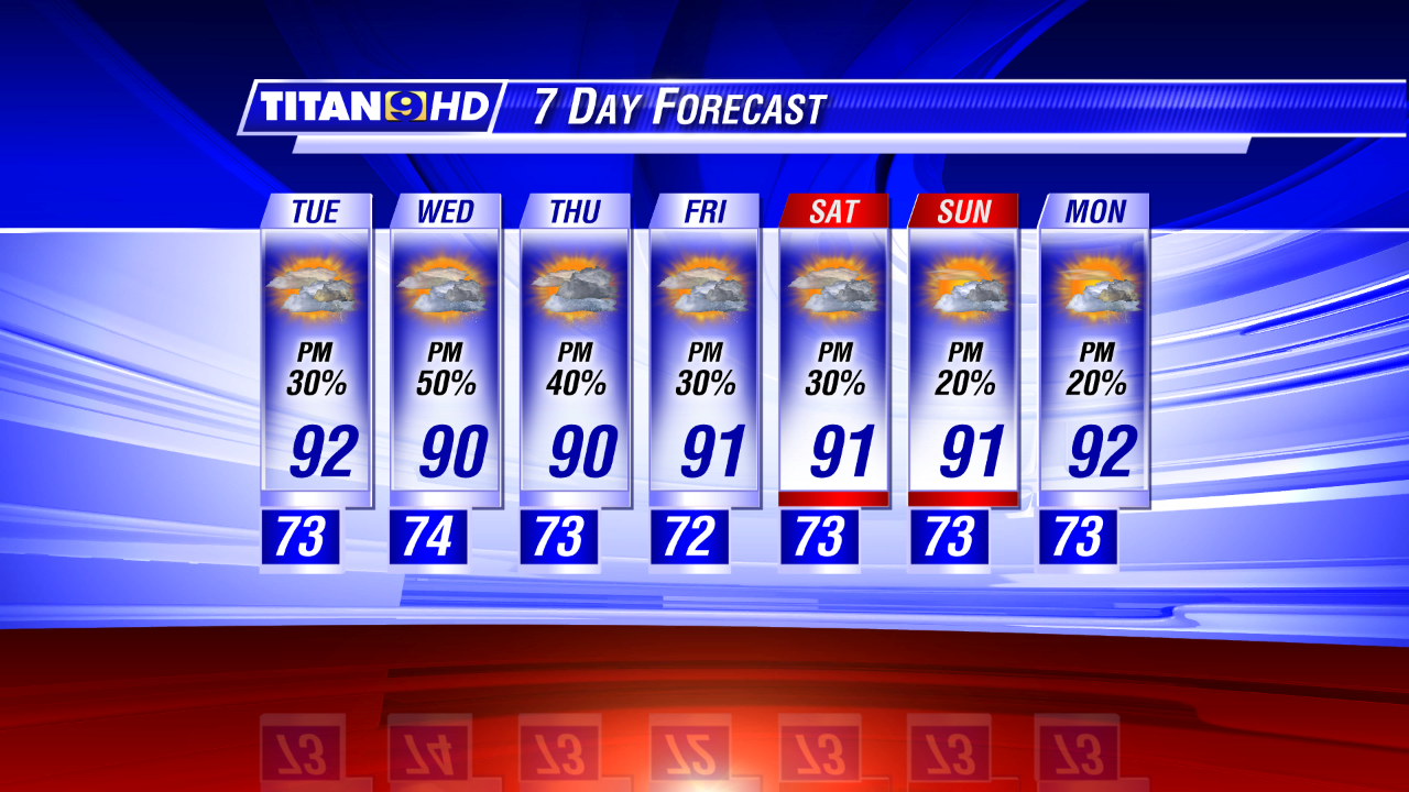
- hot and mostly-dry again for Tuesday- higher rain chances later in the week
- “Invest 91L” on the verge of becoming the season’s first ‘named’ storm?
It was a summer-season hot and mainly-dry weekend for most WAFB communities and today stayed the course. What’s more, our forecast calls for more of the same for Tuesday and probably Wednesday too.
We closed-out a ‘wet’ June with a final three days of mainly-dry weather across the viewing area. Metro Airport finishes the month with 11.36” of rain, tied with 1962 as the sixth “wettest” June in more than 120 years and the “wettest” June since 2001 (when Allison dumped from 15” to 30” of rain over southeast Louisiana over a 10-day stretch.)

Mid/upper-level ridging (high pressure) has provided a fairly solid ‘lid’ on the atmosphere, with sinking air suppressing vertical development. We expect that to be the case for at least one more day -- possibly two days -- before the ridge gives way to an advancing upper-air trough and begins to weaken. As it typical for this time of year, even with the upper-air ‘lid,’ spotty showers can’t be ruled out over the next two days. However, those that do get a shower will be the lucky ones: the rest of us will deal with a pair of very hot afternoons, with highs reaching the mid 90°s for parts of the viewing area. Factor in the Gulf humidity and we can expect Heat Index readings in the triple digits for both Tuesday and Wednesday.
Headed into the latter half of the work week -- and into and through the July 4th holiday weekend -- we expect a return to typical summer weather for the region. That means morning lows in the low to mid 70°s, afternoon highs in the low 90°s, and daily rain chances in the 30% to 40% range. The way it looks for now, Friday evening fireworks should go off without a weather-related hitch: any thundershowers that do develop on Friday should be over-and-done before the sky-shows begin (around 9 pm). And for the rest of the holiday weekend? Just more of the same.

In the tropics, eyes are on the area of low pressure off the Florida Atlantic coast and just to the north of the Bahamas labeled Invest 91L. There is clear evidence of a low-level circulation and this afternoon’s visit by a Air Force Reserve Hurricane Hunter found peak winds of 35-40 mph in the vicinity of the center. However, the National Hurricane Center (NHC) failed to upgrade 91L to a tropical cyclone (a depression or tropical storm) because of a lack of widespread thunderstorm activity around the center. Given that 91L as most of the ingredients in place, the NHC is giving 91L an 80% chance of cyclone development in the next two to five days. The good news for us is that the forecast consensus keeps this system out of the Gulf. However, interests along the U.S. Atlantic seaboard should keep close tabs on developments throughout the week.